Duke
of Kingston`s Estate
The Kingston Estate lay on part of the old Priory precinct in Bath (which in its final stages had taken over the Bishop's quarters as well). The Priory Church, now known as the Abbey, and the monks' "churchyard" or cemetery north-east of it, now the Orange Grove, were given to the City by Edmund Colthurst, it is said in 1572. The remainder of the precinct continued to be owned by the Colthursts, who had bought the Bath site in 1543, and who acquired other parcels of Priory property as well.
The Colthurst family mortgaged the property, and in 1612 the sale of it was concluded to John Hall of Bradford-on-Avon, who then held the mortgage. He was followed as landlord in 1631 by Thomas Hall, and then by John Hall II (or III, as he is called in Hall genealogies).
After the latter's death in 1711 his estate (which included other properties) went to Rachel Bayntun, who became Countess of Kingston on 20 May that year as a result of her legacy. Her husband died, it is said of smallpox, in 1713, and she herself in 1722. Her son Evelyn succeeded to the Bath estate, and to the dukedom on the death of his grandfather in 1726 (the dukedom was created in 1715).
The Duke died "of palsy" at Bath in 1773, reputedly in his house on the Parades, though other locations have also been suggested. The estate passed to his high-spirited Duchess, and after her death in 1788 to the Duke's nephew Charles Meadows, who took the family name Pierrepont and was created Viscount Newark in 1796 and Earl Manvers in 1806. A major sale of the Manvers' properties in Bath, including rents, was made in 1874.
The Colthursts seem to have done little fresh development of the area on this map. A deed of 1592, described as a lease of the estate to William Chafen, cites just over half a dozen lettings, most of them shown on Speed. (Stephen Bird has suggested a date of 1575 for the original plan for Speed's map, which is consistent with the detail of the map. It has also been suggested that the plan may have been drawn to celebrate the services held in the partly re-roofed church, described in the chamberlain's accounts for 1575.)
Development proceeded steadily under the Hall family, especially in the 1620's under John Hall I (II), and from the latter part of the 17th century under John Hall II (III). At the beginning of the 18th century it spread outside the city walls into the Ham and the Abbey Orchard. Duke Evelyn was also favourable: for instance in 1739 he signed the lease with John Wood which led to the building of the North and South Parades.
M 4184, held at the Hall ward Library, the University of Nottingham, is the record of Duke Evelyn's Bath grants and leases 1735-1766, and with its excellent plans, has provided the inspiration for the present map. The map deals with the estate "within the water", concentrating on the old walled city.
The deeds in M 4184 are on a fairly uniform pattern, most of them citing a conveyance "for ever". That of 9 on the Kingston rental, for example, has been defined as a Conveyance in Fee (or of Fee Simple), subject to the reservation of a yearly rent of the sum of £5.6.8.
The Manvers Collection at Nottingham University holds numerous other papers relating to the Pierrepont family estates. Papers are also held in the British Library, in the Egerton Charters and Mss, including material relating to the Hall family. Modern plans and site visits have also been used in creating this guide. However information is often conflicting, and it is not possible to guarantee that every item was exactly as shown. Nor can it be guaranteed that all the items co-existed. The map is a guide to progress in an age of change, rather than a photograph of a given moment. This text is also the best of our knowledge to date, and not a final statement.
NOTES
Notes on the map text
Inverted commas round a name on the map indicate a popular or traditional title.
Notes on the inventory text
Lilliput Alley. Indicates "Abbey Green Street".
Double dates. Show uncertainty whether the date is Old or New Style. (And not the usual OS/NS.)
Abbreviations for the main plans used:
KE 1725 A Map of the Scite of the dissolved Priory of Bath called ye Bath Abby with the several Lands & Tenements within the Liberty & Precincts thereof adjoyning to the City of Bath . . . Copied Jan 7 1882 Original dated 1725.
Bath Library.
KE 1750 A Map of the dissolved Priory or Abbey of Bath belonging to his Grace the Duke of Kingston 1750.
Peach Collection, Irvine Collection, Bath Library.
M 1808 15 September 1808. Deed of Covenant between the Right Honourable Chas. Earl Manvers the Honourable Charles Herbert Pierrepont and the Mayor Aldermen and Citizens of Bath for making and widening various Areas Streets and Passages in the City of Bath.
Deed Packet 3395, Bath Record Office.
Eg. Ch. Egerton Charters and Mss.
Department of Manuscripts, British Library.
OS 1886 Ordnance Survey Somerset Sheets Scale 1:500, published 1886. Bath Record Office, Bath Library.
M 4184 Bath: copies of Grants and Leases.
M 4184 Manvers Estate Papers, Hall ward Library,
University of Nottingham
INVENTORY OF PROPERTIES
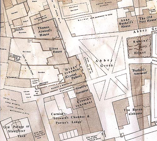
The numbers used are those of the Kingston rentals. 1. Abbey House. KE 1750 Eg.Ch.
Abbey House is illustrated in the top left-hand border of Gilmore's map. It stretched just beyond the south side of York Street, and possessed gardens to the east as well as western premises. It seems to have been the residence of the Colthursts, who presumably reconstructed it, and was later let out to tenants, who included the doctors John Sherwood and Robert Peirce (variously spelt).
David Falconer's study of the payments for the bath door and the great stairs (private way to the King's Bath) shows that Peirce paid first in 1659. He was buried in the Abbey fifty-one years later, 12 June 1710, and was succeeded as leaseholder by the a Courts. Pierce a Court, evidently named for him, held a lease of 1716.
Demolition of the house began in 1755, when the eastern Roman baths were found beneath. The Duke instigated the building of the Kingston Baths, and of other houses, using Jelly and Fisher as builders. Some of the houses (removed in 1834) stood immediately against the south side of the Abbey. Jelly and Fisher also developed part of the site directly, by an agreement of 1762, including Church Street, part of which is now called the Abbey Chambers. (Across the north end of old Church Street, the route was called Kingston Street.)
On the western land, against 23's newly extended border, the Duke built the house recently identified by Mrs. Susan Sloman as Gainsborough's (the east side of the Concert Hall site). During this redevelopment the "intended passage'' shown on this map was extended to become Abbey Street. Later called Kingston House, Gainsborough's house bore a carving of the Kingston arms, also now discovered by Mrs. Sloman in the Museum store, where it is being restored.
The main site of Abbey House itself is now the Kingston Parade.
2. The Raven. KE 1750 OS 1886
Edward Byam's house, built by lease of 1620, presumably stood on
4
the south-west side of the property. In 1631/2 the original site was expanded. Pierce a Court held the lease in 1716 as well as that of 1, though he is unlikely to have been the inn's actual manager. Charles Rotten purchased the property in 1745. He kept the turnpike by the site of the old Abbey Gate, to prevent loaded horses and carts from passing into the Abbey Green. After the record of alehouse licences begins in 1776, Kircum and Fox, victuallers, apply for a licence for the Raven in 1777.
The site is now occupied by Evans Fish Restaurant and the NSJ men's clothing store.
3i. The Tuns Lodgings and Stabling. KE 1750 M 1808
The southern front of the Tuns Lodgings can be seen in Gilmore's map, left-hand bottom border, and the northern in Johnson's and William Elliott's pictures of the King's Bath. Dr. Leyson (Leason, Lyson etc.) evidently held the lodgings at the beginning of the 17th century. By 1616 the owners of the Tuns Inn in Stalls Street took over the lease for it and the land south, while Leyson's widow was offered a place in St. John's hospice. The Tuns also secured rights of way to Abbey Lane and the Abbey Green. In 1750 Hull and Harrington, leaseholders of the Tuns Inn itself, are listed for 31.
The courtyard north of the Tuns Lodgings seems to have belonged in the early stages to the Mayor and Corporation. This is not definitely established yet.
The stabling complex was replaced by Swallow Street following the agreement of 1808. The site of the Tuns Lodgings is now within the Museum premises.
Medieval deeds refer to the land east of Stalls Street as the Bishop's court. A study of the Bishop's premises is being prepared by the Survey of Old Bath.
32 .The Hart Backside. KE 1750
The rear premises of the Hart Lodgings in Stalls Street. The lodgings are shown in Gilmore's top right-hand border, and the rear buildings
in Johnson's picture of 1675, south of the Queen's Bath. In 1750, 32 is entered as Mrs. Masters'. 32 is now within the Museum premises, with a small part of the street area.
4. 'The Old Palace or Slaughter Yard''. Baber's Houses. KE 1750 M 1808
4 and 27 were both held in 1592 by John Masters, a butcher, as well as the strip of land which became a right of way to Abbey Lane. After 1705/6, 27 was taken over by the Tuns, and houses were built on the site of 4. After 1808, Swallow Street was run through the western side of 4. The leaseholder of 4 in 1750 was Benjamin Baber.
5i and 52. "Star Chamber". M 4184, 1743
In 1591 Star Chamber, or Dr. Sprint(e)'s Lodgings, was let to Sir George Snigge. Speed shows the land, east of the baths, as empty. Gilmore shows two blocks of housing. Snigge's lease included a second property, a garret, whose site is uncertain.
In 1611 Hodnett acquired the lease of Star Chamber and its newly erected rooms, together with Sir John Harrington's gardens to the south. The property later passed to the Swallow family. At the end of the 17th century 33 was taken out of the gardens and developed by Edward Marchant, the present Elton House. Development also took place in the rest of the land. In 1743 William Swallow bought 5t from the Duke, and Samuel Bush acquired 52. Both these properties were referred to as being parts of Star Chamber or the Princes Lodgings, but 52 is evidently a former part of the gardens (as was also the southern part of 5i).
By the agreement of 1808, York Street was driven through the site. Old doorways can still be seen in the walling on the south side of the street. At the corner, the entrance to the Corporation Valuation Office is on the land of 52. The remaining northern houses (which by then included the Poor Law Offices) were cleared away in stages during the opening up of the Great Roman Bath.
6. "The Bowling Green". KE 1725 KE 1750
East of the gardens of Abbey House Speed shows an area known after the Dissolution as the Upper Abbey Orchard. Previously it presumably contained monastic buildings. The site of the eastern Abbey vestry is said to have been given to the Abbey by John Hall in 1616. Northern houses of Lilliput Alley were developed in the 1620's. 6 on the Kingston rental was formed out of the remainder of the orchard, i.e. the Bowling Green, which appears on Gilmore's map, and the housing adjacent.
Excavations for the proposed Abbey Heritage Centre have uncovered an ancient wall under the small vestry, slightly west of the vestry's south-eastern corner, not precisely on the site of Speed's orchard wall as drawn in his map nor the site of the western wall of the Bowling Green on the Kingston Estate maps. Further material on the dig and an assessment of the wall will be published by Bath Archaeological Trust.
After 1728, Terrace Walk, already existing as a line of shops, was widened and rebuilt. John Wood describes it as raised ground. Thayer's Assembly Rooms across the east end of the present York Street were opened in spring 1730. Remains of a number of bodies had been discovered on the site, some in coffins and some not.
The rooms were managed first by Mrs. Lindsey, then Mrs. Catherine Lovelace, and then the Wiltshires. The Wiltshires also held the Concert Room shown. The western part of the Bowling Green was let as a garden to 7. As John Wood writes, as well as bowling other diversions also ceased, such as smock racing, pig racing, football and so on. After 1808, York Street went through the site of the rooms.
The name of St. Peter's Gate comes from John Wood. The buildings at the north end of the Walk have been set back and the corporation house by the city wall removed. Terrace Walk c. 1780 can be seen in Bath History III, p. 59.
Note: John Wood suggests a width of 60 feet for the main rooms of Thayer's Assembly Rooms. To suit various alignments in the area, the building shown here is 58Vi feet wide.
6i. Leonard Coward's Shop. M 4184,1745
6j was formerly part of 6. The house was built in the 1740's. In 1745 it was purchased by Leonard Coward the Younger, and described as being in the possession of Joanna Davis. The site of Benjoy's Coffee House, removed as part of John Wood's development, lay along its front. It is now the Birmingham Midshires Building Society.
It can be seen c. 1788 in Bath History II, p. 122, with a doorway leading into the southern parlour. In the original plan, this space was one of two bow windows, one each side of the main door. The second doorway has now been removed.
7. "The Old Post House". KE 1725 KE 1750 OS 1886
In 1620 Thomas Cotterell obtained a lease to build against the orchard wall, and this may have been the foundation of 7 and 30, though the two properties shown on this present map are slightly larger than the dimensions given on his lease. In the Survey of the Manor before John Hall's death, and again in 1718, 7 is called the Post House, but by 1726 it is named the Old Post House.
In 1727 Ralph Allen held the site, having become a sub-tenant there as early as 1718. He also acquired part of the Bowling Green as a garden. John Wood's ornamental front designed for him in 1727 can still be seen on the north side of the property, facing east. There is no trace however of a further "northern wing", a misunderstanding. The 1762 development lease for the grounds of Abbey House leaves no room for such a wing, and there is no sign of it on later maps.
The northern wall of the Old Post House was also moved northwards at some stage and more ornamentation added. OS 1886 shows the two portions of the property linked by a row of little rooms, now removed. Signs of the linking wall can still be seen.
In 1733 the Kingston rental lists 7 as "Mr Ralph Allen his Heirs". By 1750 Philip Allen is listed for the property. In the 1760's it is given as being in the occupation of Prince Hoare.
Demuth's Coffee House and Restaurant lies on the east side of the property, and offices on the west. The ornamental John Wood extension
is now connected to Crisp Cowley.
Note: The plan here is based on the two KE maps showing the old house, and on the OS placing of the John Wood annexe. No attempt is made to link them because it is not known when they were first linked nor, in the early stages, how.
8. Blanchard's. KE 1750
8 consists of two former tenements, a western part built by Thomas Saunders by lease of 1622, and an eastern part evidently developed at the same time by Edward Bonie. William Blanchard, who is listed in the Survey of the Manor before John Hall's death, later held both sides by a lease of 1734, and purchased the whole of 8 from the Duke in 1744. By 1774 it is listed as "Nathaniel Skrine's Executors late Mr. Blanchard's house in Abbey Green Street". The site is now owned by Tilley's Bistro, who occupy the western side, while the former owners, the Stamp Shop, continue in business in the eastern part.
9. Robinson's ("Sally Lunn's"). KE 1750
Built by lease of 1622 to George Parker, "Sally Lunn's" appears to retain more Stuart features than the others, and is a rare example of an early Stuart house in Bath. The Parkers continued to be the leaseholders in the 17th and early 18th centuries. William Robinson bought the property from the Duke in 1743.
In the mid-18th century, 9 was known as "the Crown". Isaac De Vic, of 11, advertised his place of business as being next to the Crown, and a deed of 1766 refers to William Robinson's property the Crown, now let to Peter Berwick, peruke-maker and hairdresser, for £42 a year (Robinson's reserved rent to the Duke was £5.6.8.). By this deed Berwick sub-let the vaults, of which there were then four, one of them under the street, to Samuel Kirkham, victualler.
The Crown in North Parade Passage does not appear to apply for a licence after the record of alehouse licences begins in 1776. The Water rental gives the house as void 1774-1777 and possibly this marked a change of use. (Another Crown applies, in Avon Street.)
10. Jones' House and Shop. M 4184, 1746
When Thomas Woodman acquired this site in 1622, a house had already been built at the east end of it, by Robert Norlett. By 1716 it was held by William Benjoy (alias Jellicott), who evidently held 11 at the same time. By 1726 Jones held both, and was also referred to as "Benjoy" (which is apparently short for "Benjamin", a name found among the Jellicotts). The site was bought for Jones in 1746, and he was granted permission to run a coffee house.
The east end, the redevelopment of which had obstructed John Wood's plans to continue Terrace Walk farther south, can be seen c. 1788 in Bath History II, p. 122, named "The Parade Coffee House". By 1774 the property is listed in the Kingston rental as Mr. Ferry's coffee house fronting the Parade. It and 11 are now the Huntsman Inn.
Note: On the 1746 sale plan, the words "passage or chairway" actually
occur in the narrow passage with steps at the east. They have been moved west for reasons of space.
11. Jones'. M 4184, 1746
11 was evidently first built by Thomas Grymes by lease of 1622. It passed to William Jellicott and then James Jones, who purchased it from the Duke in 1746. At that date it was occupied by Isaac De Vic, wine merchant.
Jones had permission to wall up the passageway through it to the Bowling Green, since there was now access at the east end of Lilliput Alley, due to the creation of the Grand Parade (North Parade). Some plans show steps in the passage.
Isaac De Vic hailed from Southampton, where his father was in business. His firm had branches at Southampton, Bristol and Guernsey as well as Bath, and imported fine wines such as claret, burgundy and champagne. In 1753 he advertised the launching of a bank, giving his address as near the North Parade. In 1761 John Viel, De Vic's cooper for over twenty years, set up in business on his own account in St. James's Street.
11 is now part of the Huntsman Inn, with Pope's Restaurant above.
10
12. Phillips' House. M 4184, 1739
12, first built by Robert Norlett in 1620/1, stood immediately in front of the east end of 10, within the hatched line. A width of six feet was left south of it for the way to the old Abbey Orchard. It was taken down as part of John Wood's development, as was the stretch of city wall. Its last occupant was Phillips, a gardener who evidently cultivated the land used for the Parades.
13. "The Garden House". M 4184, 1743
Mrs. East's Garden House is shown in Gilmore's left-hand bottom border. The western wall of the garden, shown in Speed and Gilmore, was probably Tudor (parts of it still remain). Part of the land enclosed in it once belonged to the Tudor Abbey Green. Permission was given to the lessees of 13 to use stone from the land, presumably from monastic ruins.
In 1717 13 was let to William Seagar, apothecary. In 1743 William Galloway bought it from the Duke. "Gallaway's Buildings" were built around 1749-50. A lease of January 1750 to do with the redevelopment includes a plan which shows buildings "lately erected".
Permission was given by this lease for arches to continue up to the entrance to the Grand Parade (North Parade). Lilliput Alley can be seen sloping up to the higher level. Earlier plans of the Parade show steps. There is also a ramp up to the southern end of the buildings. The northern boundary of 13 was straightened during redevelopment, as shown in the inset.
It is possible the site of the house shown in 13 had a special connection with the Prior. A study is being made of, this which will be published if any definite conclusions are reached.
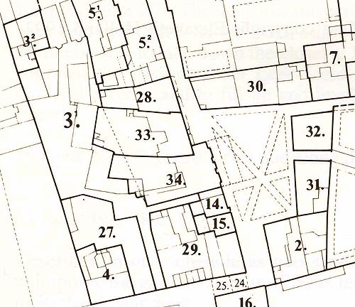
14. Scott's Tenement. KE 1750
Speed's map depicts a building in the area of 14, but probably farther east than on this map, since 34 was set back twenty feet, and probably 14, 15 and 29 also. In 1719 John Wiltshire renewed the lease for a "ruinous Messuage" formerly in the tenure of the Widow Player, now
re-edified and divided. In 1742 the property was purchased by Elizabeth Scott, widow, who surrendered a lease of 1734. The site is now Marsh's the jewellers, 9 Abbey Green.
15. Crouch's Tenement. KE 1750
Like 14, this property was probably set back. In 1716 and earlier it was leased by the Atwoods, but by 1726 at least it was in the hands of John Crouch, barber and periwig-maker. In the Kingston rental of 1774 it appears as "Mr Chivers for Crouch's house in the Abby Green". It appears to be one of "Earl Manvers Houses", see 29. The site is now Sixes and Sevens, 8 Abbey Green.
16. Abbey Gate House. KE 1750
In 1716 16 was described as a low room, chamber and cockloft to the right of the old gateway. It can be clearly seen south of the gate in Gilmore. In the 1726 rental it was called a "House Adjoyning to the Abby Gate".
When sold to William Palmer in 1742 it was called "new erected" but formerly a cockloft, etc. By 1753 it was in two messuages, in the occupation of William Orchard and William Harding, cabinet-maker.
Part of the site can be seen in Loxton's picture of the Abbey Green, c. 1910, by a pillar matching the pillar still standing by Evans Fish Restaurant (from the gateway to the grounds of Weymouth House). The street on the west side of 16 became known as St. James's Street, though it was once called Leer Land (also Lear Land, or Lands). The site is now the back vestibule of Marks and Spencer's.
17. "The Coach House". KE 1750
Like 16, and 18-20, this site appears on Speed, shown in the row of houses by Hull's Garden. It was bought by Mrs. Catherine Jones, spinster, in 1742, and was then known as the Coach House. In John Hall's time it had been called "Ostons", presumably for Johnson, a tenant. The site now lies inside Marks and Spencer's.
12
18. "The Thatched House". KE 1750
In 1726 the Kingston rental refers to 18 as "now the Thatched House". John Hawkins of Bath, cabinet-maker, agreed in 1703 to build a good house there. He repeated his promise in 1708. There were then regulations against thatch. However a pub called "the Thatched House" existed in Walcot in the 1770's, and it may simply have been a popular name.
In 1742 18 was bought by William Palmer, grocer. The site is now inside Marks and Spencer's.
19. "The Meeting House". KE 1750
19 was part of a group of buildings known as "the Shury Stables" (from an old term apparently referring to "shoeing"). The Kingston rental of 1726 records, "'twas a Quakers Meeting now Inhab.d by Chas. Griffiths", a music master. It was bought in 1742 by Mary Webb and William Harrington, clerk. 19 also possessed the courtyard between
20 and 20a, including the necessary house, which Lord Weymouth had built over (a situation which caused some problems) and the brewhouse. The site of the Shury Stables lay mainly in Littlewoods'.
20 (or 202). "Shury Stable". "The Theatre". M 4184, 1743
20 was also part of the Shury Stables, held in 1627 by Richard Chapman. In 1709 John Woodman agreed to build two houses himself on 20 and 21, on land once held by Rogers. 20 was to comprise a theatre, on a plot fifty feet in breadth. By the rental of 1726, Thomas Warr had built a dwelling-house on the site, so the theatre was shortlived, and nothing is known about it. In 1743 the site was bought by Mary Warr, widow, and Thomas Atwood, and described as 'formerly called the Theatre". It is now in Littlewoods'.
20a (or 20,). Outbuildings of Lord Weymouth's House. M 4184, 1749
This was originally the site of a stable standing at the south end of Hull's Garden, which can be seen in Speed. In 1749 the Duke sold it to Lord Weymouth for use with his house, describing it as "formerly part of a Tenement called the Theatre". Hull's Garden, the site of the house itself, seems to have been sold long before. One or two transactions which have been cited as referring to Lord Weymouth's house have proved to refer in fact to 20a, the outbuildings.
The covered passage behind Littlewoods' and Marks and Spencer's runs through the eastern tip of 20a.
21. Land outside the Walls. M 4184, 1743
21 was part of the Shury Gardens, held in 1627 by Richard Chapman. John Woodman seems not to have completed the proposed house on it (he went bankrupt). Thirty-four feet was originally allotted for this second house, which with the fifty feet for 20, the theatre, would have to come to the north side of 39, Marchant's part of the agreement of 1709. As, apparently, a substantial house was not built here, space remained for the "way" to develop which came to be called Orchard Street.
The site is now mainly in Littlewoods', and is crossed towards the east by the covered passage.
22. Ambry House.
22 is not included in this map as it was west of Southgate Street. Known as Ambry House, it may have been the site of a former almonry of the Prior (an almonry is also mentioned by the bridge in medieval times). It was bought by Samuel Purlewent in 1745. The site was under the borough walls and west of the lane.
("Hull's" or "Bull Garden". KE 1750)
Bull Garden does not seem to appear on the Kingston rentals, and was apparently disposed of early on. The land is referred to as part of the court of the Prior in a deed of 1262.
In 1598 it was rented from the Colthursts by John Hull, shoemaker. A wall still runs on the site of John Hull's newly built boundary on the north, along the south side of the Fish Restaurant and North Parade
14
Buildings (it appears to be of older workmanship on the west than the east). The south-eastern boundary of the Priory precinct was the city wall itself, south-east and south of the garden and the stable at the south end of it. A stretch of the city wall can still be seen.
By the 1740's the "house in Bull Garden" was known as "Lord Weymouth's House". At the time of the 1749 sale of 20a, the house seems to have been occupied by one Dorothy Robinson. The site eventually housed the National Schools (Weymouth House Schools), which were built north of the old house. It is now partly occupied by buildings, while the covered passage behind Marks and Spencer's runs through the middle of it. Only a small part remains open, to the east, now used as a yard.
23. "The Tennis Court". KE 1750
"The Tennis Court" is marked on Speed's map by "L". The premises became "Mr Mores Lodgings in the Abby Church Yard", shown in the bottom right-hand corner of Gilmore. By the sale of 1744 to John Moor(e), arrangements were made for the Duke to create a new passage from the Abbey Green and John Moor was then to block up the passage through his site and build a new eastern boundary in line with Star Chamber land (5i). A memo of 1754 reports that the Duke had by then removed the shop in the way of the new passage, though in 1755 there still seems to have been something left to remove. The shop's last tenant was Howse, an apothecary. Richard Collins held the premises west of the shop.
The block was set back in line with the present Pump Room and Abbey Passage created on the west. All the houses in the block were demolished in the 1890's to make way for the new Concert Hall. Roman walls suggesting a large rectangular building were found beneath, which Major Davis declared to be part of a great hall, which he believed might have extended under the Abbey. (Others have suggested that the building might have been the Roman basilica or ' 'town hall''. The issue is a controversial one.)
Note: The encroachment from the Tennis Court site 24 feet by 1 '/2 feet
was originally considered to intrude into the churchyard of SS Peter and Paul, but the later parish boundary of St. James's took it in. The encroachment was outside the Kingston boundary.
24 and 25. The Old Abbey Gate. KE 1750
24 and 25 were rooms above the old Abbey Gate. Before it was pulled down Tobias Suger held the east part, 24, and Thomas Browne the west, 25, each paying 6d. yearly. The gate was opposite Evans Fish Restaurant, by Marks and Spencer's. The rental of 1733 reports, "the house now pulled down". Someone then incorrectly wrote "12" on the site in the Kingston Estate map.
26. The Parades. KE 1750 M 4184, 1740
The land outside the eastern city walls was known as "the Lower Abbey Orchard" after the Dissolution. It originally included 38, Harrison's, and 37. In 1570 it was listed as being in the tenure of John Bushe. In 1739 a development agreement arranged for John Wood to spend £4,000 or more on building, and he records that on 10 March 1740 the first stone of the Grand Parade (North Parade) was laid. It seems to have been completed that year. The city wall was taken down to allow access, and Benjoy's Coffee House (at the front of 61) removed.
The South Parade was begun on 27 January 1743. Duke Street and Pierrepont Street link the two. The Parades are on raised ground as the land formerly sloped down to the river, as can be seen in the Parade Gardens.
27. Stables of the Tuns. KE 1750 M 1808
This was formerly part of John Masters' tenement mentioned in 1592. It was taken over by the Tuns in 1705/6 and referred to as the Long Stable, Cross Stable, Malthouse and Kiln. It remained part of the Tuns complex until Swallow Street was developed, running through its western side.
28. Atwood's House. M 4184, 1743
Once part of the gardens of Hodnett's tenement, and then Swallow's. John Hall arranged for Charles Swallow to develop it in 1699, Thomas Atwood, glazier, leased it in 1721, and in 1743 it was purchased by Thomas Atwood the elder, alderman. The front door is now in a
16
different position from that on the sale plan, suggesting redevelopment, while the basement shows signs of having once had two exterior doors, The house is now in flats.
29. Cornish's. KE 1750
A lease of John Hall to Henry Moore in 1616 for 29, the Porter's Lodge and Steward's Chamber, included the rooms and gate house over the gate, referring to 24 and 25, though whether to 16 as well is not certain. In 1716, 29 was rented by Richard Cornish as two houses. By 1729 it was described as three houses, and by 1750 as four tenements. It does not appear in the sales of M 4184 and one 18th century entry refers to it as "his Grace's buildings late Cornishes". A 19th century plan marks it "Earl Manvers Houses". The site now contains several shops. (The front of the street has been set back.)
30. Anne Bushell's House. KE 1725 KE 1750
The site of 30 seems to have been developed by Thomas Cotterell by a lease of 1620, as with 7, though the measurements do not match the houses exactly. 30 seems to have been "Balls house in Bath wch Masters rents", mentioned by John Hall in his Notebook in 1698, when Bushell, Town Clerk of Bath, added two lives to his wife's in the lease.
In 1718 leave was given to rebuild the house, carrying the building as far as "Mr. Accourts" kitchen. As the present plan, taken from the Kingston Estate maps, only shows a small house, it may be out of date. However John Wood's map of 1735 still shows a large garden west of the actual house.
In 1762 the site of the present block north of the Abbey Green was included in the development lease to Jelly and Fisher. Solloway's, Fine Linens, lies on the eastern side of the site of the old house, Church Street on the western side. Shops and flats lie on the gardens. The name "Abbey House" is given to the block of flats, though they are not on the site of the old Abbey House. Similarly when the Duchess of Kingston is listed for "Abbey House" in Rate-books such as those of 1776 and 1779, this refers to property appearing under Kingston Buildings, not Abbey Green.
Jelly and Fisher also obtained permission to make vaults fifteen feet long stretching under Abbey Green. The vault to the east appears to have been the coal cellar of the present Abbey House.
31. "Bushell's Tenement". KE 1750, adapted to OS 1886
In 1698, while making out a new lease for Ball's house (see 30), John Hall agreed that John Bushell, Town Clerk, should build "a very substantiall house of all the garden next to Mrs Easts garden wall", evidently referring to the site of 31. The site is shown as a garden still on Gilmore, and may have been the garden fifty-one feet by thirty-four rented to Thomas Hall, "cordwyner" (shoemaker) in 1629.
In 1720 Dr. Bettenson is stated to live there. In 1726 the leaseholders are still the Bushells but it is described as the "House where Dr. Bettenson liv'd". In 1744 it was sold to Samuel Purlewent, with permission for him to make an area in front of the house as far as the rails. The site now includes two houses, 3 Abbey Green, the Bath Centre for Voluntary Services, and 4 Abbey Green, Imago. An old timber-frame wall was found at the back of 3 Abbey Green which may be part of Bushell's original building.
32. Robins' House. KE 1750, adapted to OS 1886 Eg.Ch.
32 was built by Sam Fry by an agreement with John Hall of 1698. John Wood held a lease of 1744 permitting him to build over Seager's Passage to the south, and to make an area before the west front of the house, but did not carry it out, and the house appears to have continued in the possession of the Robins family. In 1774 it is listed as "Mr Robins Executors a house in the Abbey Green".
The house has the right of ancient lights for seventeen feet on the east, creating the open space now known as Lilliput Court, on 13's land. 32 has been restored, and part of the eastern side taken down. The site now contains Abbey Green Gifts, 2 Abbey Green, and Cutting Edge and the Abbey Green Florists facing North Parade Passage.
Note: The present house has a ground floor window at the south-west, apparently older than the 1740's, but not shown on the plan used, which comes from the Egerton Charters. The window was discovered, blocked up, by David Brain during restoration.
18
33. Elton House. M 4184, 1749 KE 1725 KE 1750
In 1699 John Hall leased part of Swallow's garden to Edward Marchant (or Merchant) on condition Marchant built a "good house", for which he was excused the fine (premium), which would imply a substantial building. In 1749 the property was sold by the Duke to Jacob Elton, who had married Marchant's widowed daughter Elizabeth Brydges. It appears they resided in Bristol and let the house out.
In 1962 Miss Philippa Savery purchased it, and donated it in 1982 to the Landmark Trust. It is now used as holiday flats. A second front door stands to the north, with the name "Elton Cottage P. Savery" by the bellpush, flanked by two bow windows. The site at the rear now known as "the cottage" lies along the north side of Elton House's garden.
Notes: It is not known how 33 came to intrude so far into 34. Speed shows the boundary line as straight.
The Landmark Trust believes the level of Abbey Green was deliberately raised, so that 33's original ground floor is now its basement. Elsewhere a date of 1750 has been suggested for this. Street levels rise spontaneously over the centuries. The Survey of Old Bath has no documentary evidence yet that the level of Abbey Green was deliberately raised. Wherever it is known that levels have been purposely raised, it is mentioned in this inventory. The area in front of 33 has been taken from KE 1725 and KE 1750, and steps added to match those on 28. The sale plan of 1749 does not show an area.
34. "Higgs' Tenement". M 4184, 1753
In 1616 this site was let to Thomas Cotterell, joiner, evidently for development, and described as garden ground in the occupation of Robert Evans. By 1632 it was let as a messuage and garden to William Chapman, mercer.
The house appears as "Mr Webbs Lodgings in the Abby Green" in the right-hand bottom border of Gilmore's map. With a central porch and a bay at each side, it appears to match the plan shown here, from M 4184. Gilmore shows the house as set back twenty feet from Speed's site, as described in early 18th century leases. In the Survey of the Manor before John Hall's death, early 18th century, it appears as "Mrs Webb for Higgs". In 1716 Thomas Bushell (leaseholder of the Tuns
Inn) held a lease "for a house late Joseph Higgs in Abby Green". It later passed, like the Tuns, to Harrington and Hull. The property was bought by John Harford, apothecary, in 1753. A plan of 1816 shows the west side of the plot as "Cruttwell's Wagon Yard". The site is now the Crystal Palace.
35. "Chappie's House". M 4184, 1739
35 was part of the Shury Gardens and was developed by Henry Chappell (variously spelt) after 1707/8. Richard Marchant bought the property in 1736, paying the Duke £1,000 for it and 36. The plot is described as twenty-nine feet in depth, and most of the land shown with 35 in the agreement of 1739 and on this map seems to have been sold as part of 36's plot. 35 may be "The Great House . . . Henery Chappells" of the Rate-book, 1747. 35 as shown here lay partly in the street (walkway) and mainly under the building now called Northwick House.
36. "Chappie's Tenement". M 4184, 1739
36, north of 35, was also part of the Shury Gardens. It was part of the development agreement of 1709 for land belonging to Rogers. Marchant bought it in 1736, with 35. The plot then evidently included land lying east of 35.
36 may be "The Little house Late Henery Chappells" of the Ratebook, 1747. The courts marked on the west of Marchant's two "freehold houses" were to be taken down as part of the Duke's development agreement with John Wood in 1739, as they were obstructing the way. 36 lay in the street (walkway) and under Northwick House.
37. Old Orchard Street. M 4184, 1739
37 was formerly part of the orchard, apparently obtained by Chappell from Walter Masters. In the schedule of 1750 it is described as being in "divers small Tenements". The name Orchard Street is used on John Wood's map of Bath, 1735. On a plan of 1745 the name also covers the modern Pierrepont Place.
20
The theatre was begun in the winter of 1747, according to John Wood, on land belonging to 26, and opened by 1750. In 1766 it was extended south-west to the dimensions of the present Masonic Hall, into what was once a yard of Cornish's Buildings, with some extra scraps of land to the east of the yard.
John Palmer, tallow chandler, and Henry Fisher, master builder, as a nominee, are named on the deed. They are to expend at least £1,000 on a substantial stone and timber building. John Palmer is also to raise their half of Orchard Street to such height as the Duke directs. In 1774 the theatre is listed under John Palmer. A plaque on the Masonic Hall gives something of its history.
38. "Harrison's" or Simpson's (The Lower Assembly Rooms). KE 1750
In March 1709 John Hall gave Thomas Harrison a lease of part of the Abbey Orchard, where Harrison was to spend £1,000 in building. John Wood writes that Harrison's Assembly Rooms were begun that year (he puts it in the Old Style, 1708), and the second room built in 1720 to the design of William Kelligrew, with "a Stair Case between them".
Harrison was succeeded as manager by Lord Hawley and "his last bosom Companion", Mrs. Hayes. The Bath Journal for 4 February 1745/6 records, "Last Tuesday night died Lady Hawley (Relict of Lord Hawley) who has for several Years past kept one of the Houses here for Publick Assemblies, Balls etc known by the name of Mrs. Hayes's".
The next manager was Simpson. Plays were advertised at Simpson's, and apparently came to be held in a small playhouse under the ballroom.
A small corner of Harrison's land was given up by agreement of 1745 to allow John Wood to widen the Grand Parade (38a), and another piece to complete the frontage of South Parade. Harrison's possessed a walk by the river, known as the Green Walk, with a summerhouse, to be seen in Thomas Robins' picture. Between 38 and the Green Walk lay a piece of ground known as "St. James's Triangle" on which building was forbidden. Some Parade deeds mention access to it. Simpson himself had permission to build north of his existing rooms, as far as Shay lor's house by the Grove.
After Simpson's time Cam Gyde is named as manager. Once the New Assembly Rooms were opened in 1771, these rooms came to be known as the Lower Assembly Rooms. They were destroyed by fire in 1820, and the Royal Literary and Scientific Institution succeeded them on the site. It was cleared away in 1933 for street widening.
The Lower Assembly Rooms were partly on the site now known as Bog Island. St. James's Triangle is now the Parade Gardens.
39. Marchant's. M 4184, 1739 KE 1750
39 was developed as part of John Woodman's 1709 agreement with John Hall (see 20). The land was formerly part of the Shury Gardens, once held by Rogers. By the Duke's agreement with John Wood, 1739, Marchant was to take down the closet at the north-west corner, which confined the passage from Leer Land to the Abbey Orchard (i.e. Orchard Street), and to fill up and level a vault also obstructing the street.
39 lay in New Orchard Street and along the front of Northwick House.
39i and 392. KE 1750
Described in one schedule as two small pieces of land added to 39 to improve the gardens, and in 1750 as tenements and gardens in lease to Richard Marchant.
40. The Ham. M 4184, 1739 KE 1750
"Hamm" signifies "water meadow". Although plans were made for its immediate development, for instance John Wood's "Royal Forum", they did not materialise, and the site continued as market garden land. It now contains the Railway Station, Bus Station, Police Station, Manvers Street Car Park, Manvers Street Baptist Church, St. John's Roman Catholic Church, and other buildings and shops.
40a. M 4184, 1739 KE 1750
"Land now walled up as Henry Chappel's garden, but formerly part of the Ham."
40b. M 4184, 1739, 1766 KE 1750
A strip of land part of the Ham, twelve feet wide and five hundred and ninety-four feet long, given to John Wood to form part of the frontage of South Parade. A small piece from the east end of the strip was ceded in 1766 for the extension to the Orchard Street theatre. There was some confusion by then about the boundary at that corner.
© Text copyright Elizabeth Holland 1992.