The
Bishop's Palace
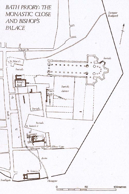
The clearest reference to the palace is Leland's in 1542, where we are told 'this John erectid a palace at Bath in the south-west corner of the monasterie of St Peter's at Bath one great square tour of it yet appere'. Other 16th and early 17th century references make it clear the the 'Old Pallace' was to be found south of the King's Bath and west of Abbey Green. In particular, the western wall of the close is identified as coterminous with that of the palace, and Old Palace Yard (now vanished) is identified as being in this area. Measurements given in documents in the early 13th century, outlining part of the bishop's palace (apparently his private quarters, the 'Bishop's Bower'), fit well with a plot on the southern side of the yard. Excavations here in 1984 and 1985 uncovered substantial masonry buildings whose inhabitants had enjoyed a noticeably high standard of living from the late llth century until the early 14th. The buildings can be safely ascribed
to the bishop and his retainers. The condition of the buildings then suffered a steep decline. This picture matches the documentary evidence of the declining fortunes of the priory, especially after the bishops ceased to reside in Bath altogether after about 1290.
Work was still being carried out on the episcopal palace in 1279, when a private chapel for the bishop was created out of the nave of St James' church. This was thought convenient, as it adjoined the bishop's chamber (the chancel being demolished and, as the bishop's charter permitting all this records, marked with a cross to avoid desecration). As noted above, the parishioners, who must have been a great nuisance to the bishop for nearly 200 years, were removed south to a new plot granted them for the purpose. The bishops, however, must rarely have used the new chapel, and by 1328 were ready to pass over the whole of the private residence to the prior and brethren.
The result of the local inquisition was then delivered to a royal clerk in London, who copied all the details from it into the royal permission to alienate, granted by letters patent. That was standard procedure. To make matters clear the letters patent give the inquisition of 27 June as the source of information. Unfortunately the royal elerk made an understandable error. In the inquisition document the word diicctitos (two hundred} was split between two lines. The clerk evidently failed to notice the tin, carelessly read centos as CCHIIIIII and so the figures became 170 ft by 130 ft in the letters patent issued to the bishop (1'KO €66/183 111.7; Wells, I, 473)- The bishop duly granted to liatb Priory the bishop's palace and courtyard, for which the prior and convent agreed to pay a yearly rent of .£1 (BL Eg, 331(1, f. 4(iv; Ralph of Shrewsbury, 291-02, 314). an arrangement which continued until the Dissolution (I'ahr l-fflrs, l. 123). It comes as no surprise that the bishop's clerk simply copied the figures for the size of the property from the letters patent, the document in his possession. So the proposal by Chapman a al . that the bishop's close was split into two modules of 170 ft by i 30 ft lorming an L-shape c.innot be sustained.
John Speed's map ol Bath, published in 1610, was used as supporting evidence lor the modular theory. It shows the former priory conduit house at the north-east corner of a garden jutting out sharply into Abbey Green, as though forming the base of the proposed l.-shape. Again the problem is one of inaccurate copying. Speed's map is a poor copy of a larger, more detailed map by Henry Savile c. 1600 (Mauco 1993), which shows ihe property in question further west (Illus. 2). In 1616 permission was given to demolish the conduit house and build on the adjoining garden. The dimensions of (14 ft by 43 ft (19.5 m by 13.1 m) given in the building lease (Bl. Eg. ch, 5827) correspond as nearly as one can judge with the garden as shown on Henry Savile's map. The lease .ilso included a two-fool wide strip of Abbey Green beside the garden. Unless there was another copying error, il would appear that the house built on the garden was later leased together with a larger part of the Abbey Green to make a private area in front of the house, since in 1720 a new lease granted the property 'except 20 ft (6. i m) from the front eastwards' (BL Eg. 3647. f i").