
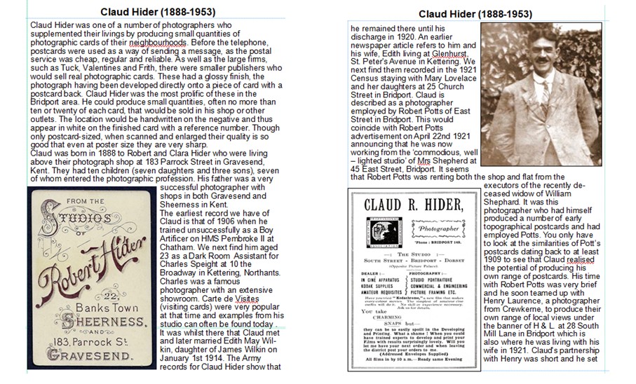
|
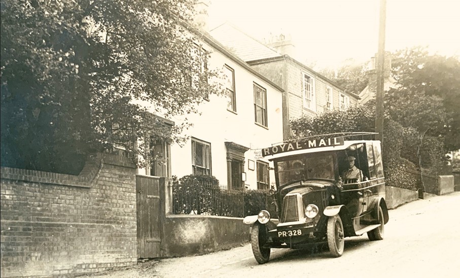
THE WEB FRESHFORD SITE |
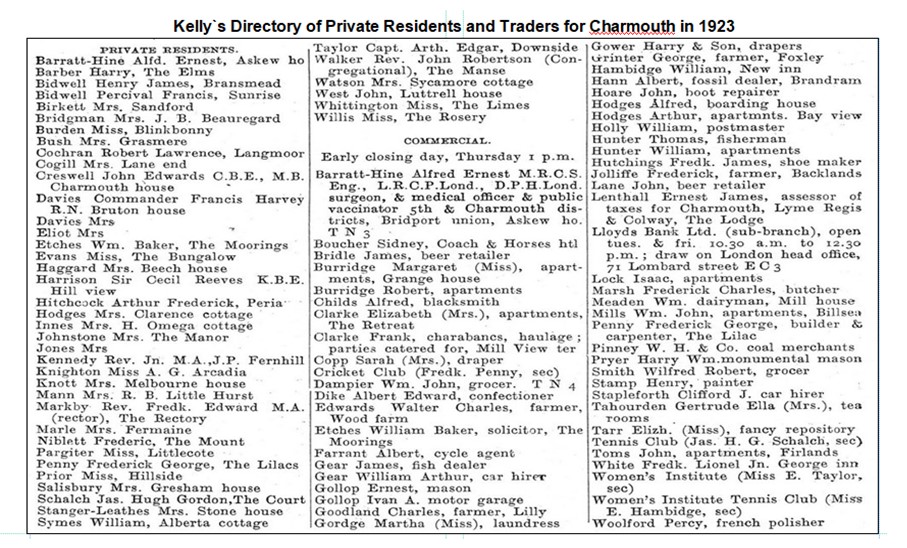
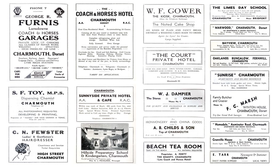
We are fortunate that Kelly’s produced a Directory of Private Residents and Traders for Charmouth in the year 1923, the year after Hider’s first
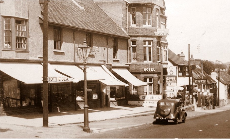
postcards. It is interesting to read the diverse businesses. Amongst these were a Cycle Shop, French Polisher, Monumental Mason, Fossil Dealer and Coal Merchant. There were five Pubs The New Commercial Inn, The Star Inn, The George Inn, The Royal Oak and the Coach and Horses. Visitors had a number of places to stay, which included hotels, guest houses and apartments. Considering how few cars there were, it is surprising to see that there were two garages – Gears and Stapleforths. It seems that Charmouth had so much to offer that it was almost self-sufficient.
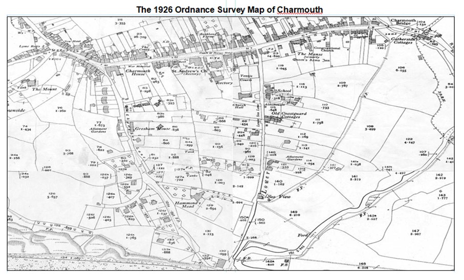
The 1926 O.S. Map above is helpful in locating streets and buildings referred to in the book. The selection of photographic postcards produced by Claud Hider follow an imaginary circular walk of the Street highlighting interesting buildings that feature in the views and their past. Many of these are extremely rare and have never been published in a book before. The walk will begin and end at the junction of Lower Sea Lane with the Street, where The Pharmacy is today. The illustrations then widen out to include Lower and Higher Sea Lane as well as views along the beach. There are finally views on the outskirts of the village and key events that Claud recorded, such as the 1924 landslip and the escaped lion in 1929. Claud
created a unique record and covered most of the village with his camera. Few areas were missed and even these may still turn up in time.
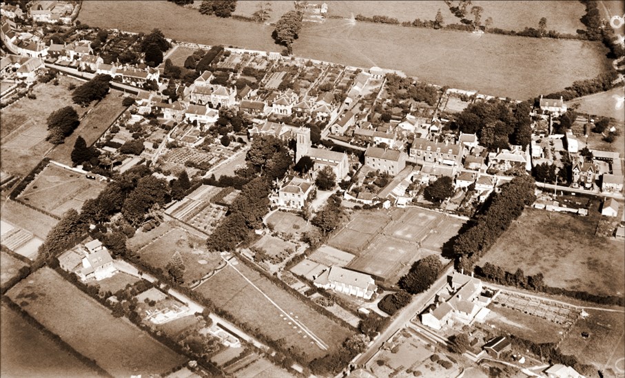
This aerial photograph taken in 1926 covers most of the area shown in the book. It clearly shows how the development of the village was confined to the length of The Street by the 14th century monastic wall still to be seen to the north. St Andrews Church and its Rectory are seen in the centre with the Coach and Horses Hotel on the right. A large number of houses had extensive gardens. The Church Hall and School faced each other in Lower Sea Lane. The large field on the corner of the Lane and the Street was known as Pear Tree and was owned by Harry Pryer who had his builders and masons yard on part of it. The large house near the left corner was Hammonds Mead which was to later become a hotel.
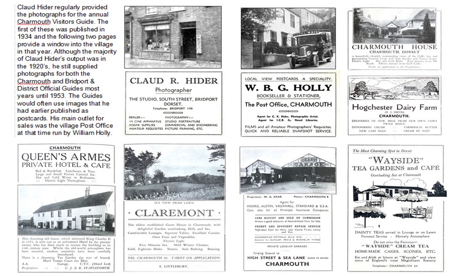
Claud Hider regularly provided the photographs for the annual Charmouth Visitors Guide. The first of these was published in 1934 and the following two pages provide a window into the village in that year. Although the majority of Claud Hider’s output was in the 1920’s, he still supplied photographs for both the Charmouth and Bridport & District Official Guides most years until 1953. The Guides would often use images that he had earlier published as postcards. His main outlet for sales was the village Post Office at that time run by William Holly.
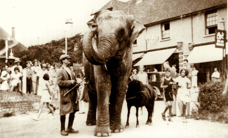
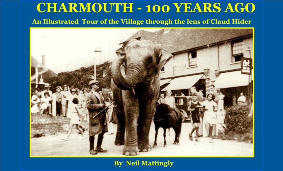
This astonishing photograph shows an elephant from a visiting circus outside the shops, soon after they were built in 1934. Two years earlier the village made the national news when a lion escaped from a circus car when it hit a tree just outside the village. The elephant is standing near the entrance to Harry Pryer’s stone masons yard. This was sold on his death and the shops we know today were built on the site soon after. On the other side of Lower Sea Lane stood Sandford House which was demolished in 1958 to widen the narrow entrance to the Lane.
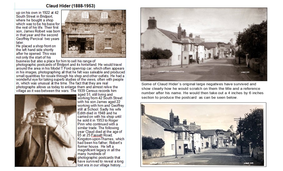
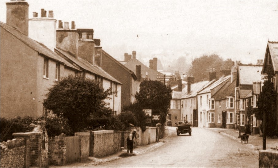
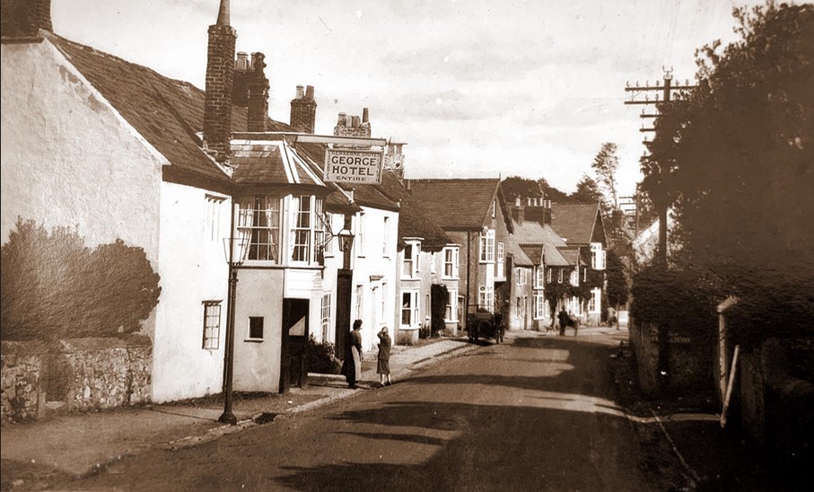
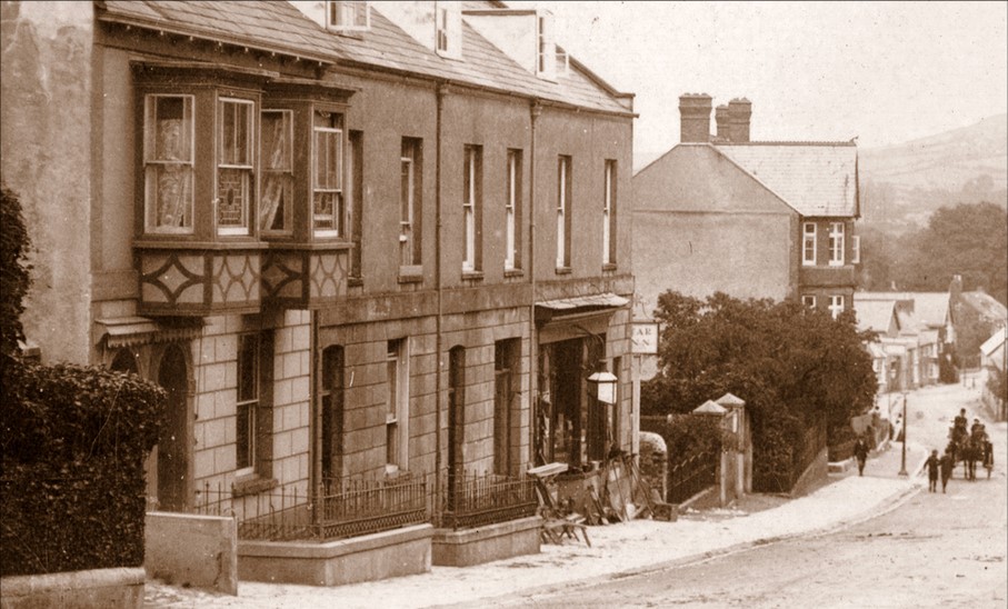
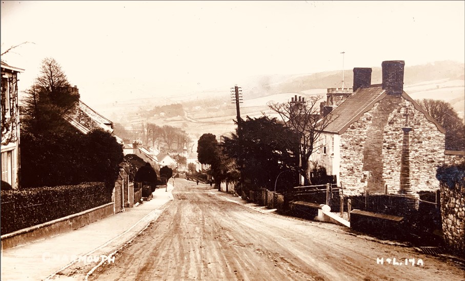
This view looking down the Street is almost unrecognizable today, apart from the building on the corner, which houses The Pharmacy. The original structure dated back to the 18th century, when it was the office for the Steward for the Manor. After a time as a carpenters workshop it was bought by the Pryer family who established a monumental masons there. This flourished until the death of Harry Pryer in 1932, when the field to the right known as Pear Tree was sold to Stapleforth and several shops and houses were later built there. The large gabled building in the centre is the Abbots House.
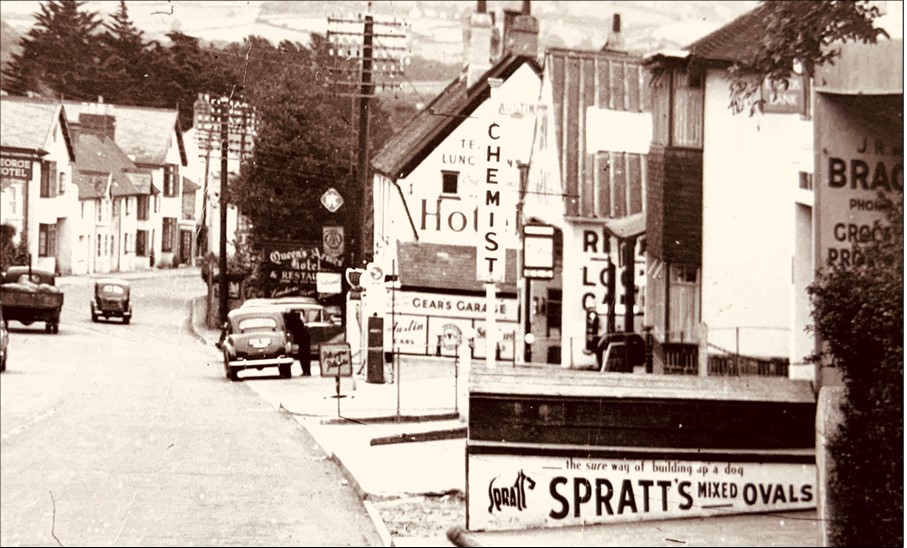
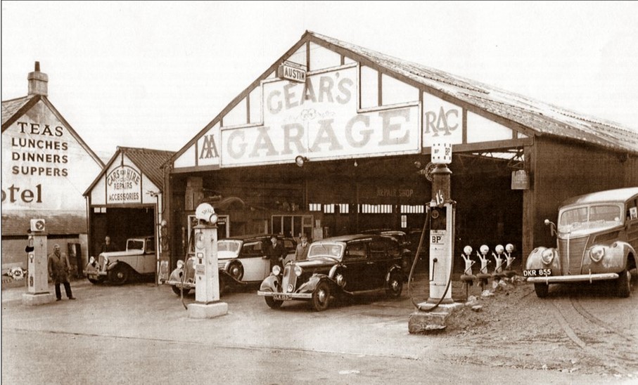
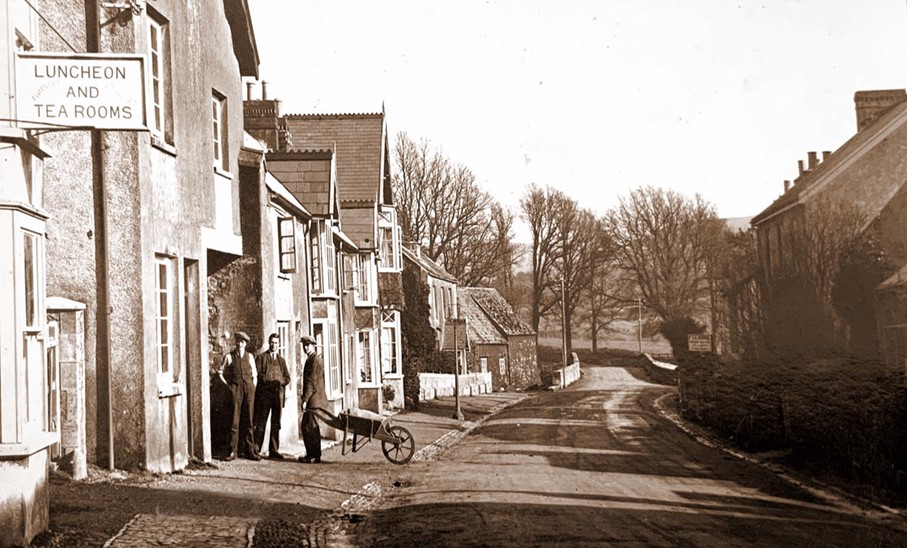
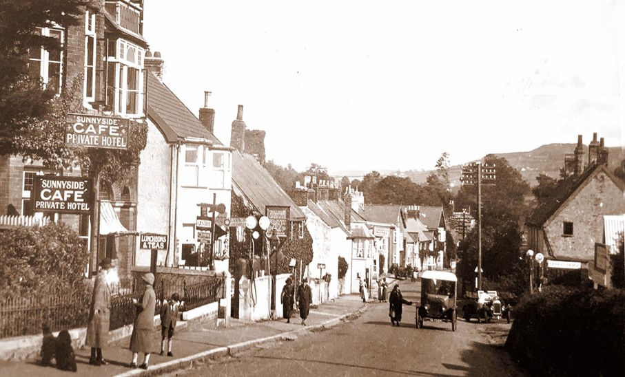
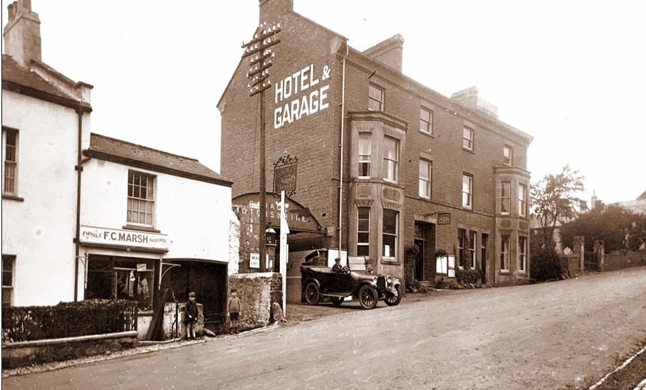
Almost the same view taken by Claud Hider thirty years later towards the end of his life and used in a 1953 Guide to the village, clearly showing the transformation of the field once known as Pear Close. In the foreground can be seen the entrance to Bragges Store. In the distance are Lloyds Bank and the Chemist with Gears Garage and the side of the Queens Armes Hotel and Restaurant. Although most of the buildings are still there, the types of business have changed.
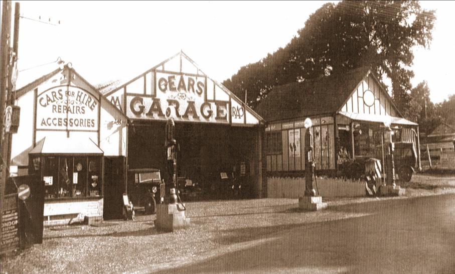
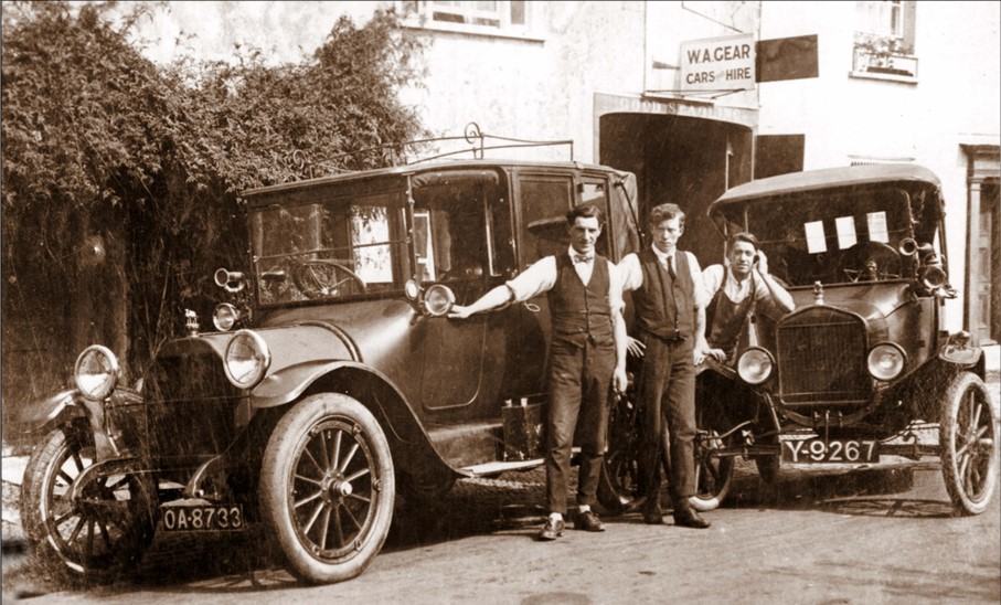
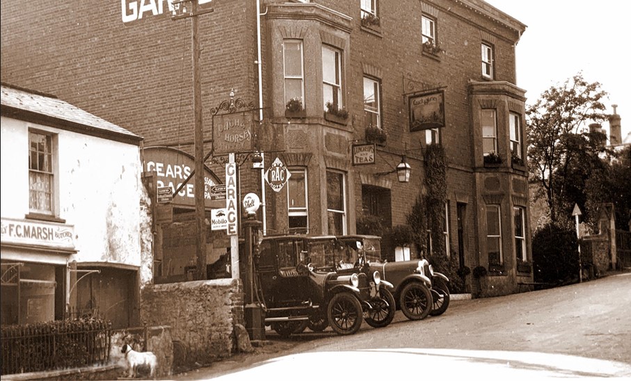
This is one of the earliest photographs of the garage opened by Billy Gear in 1927. In time he built a small garage on the field known as Pear Close which gradually grew into a substantial building with a large frontage onto the Street and workshops stretching behind it. He must have been Charmouth’s foremost businessman at the time, for as well as the garage he owned the large car park by the footbridge near the East Cliff and built a number of houses in the village.
The photograph of the outside of his garage shows Billy Gear standing smartly in the centre with his workmen alongside his vehicles. Adverts in the local directories detail the extensive range of services he could offer from his well-equipped workshop for repairs and servicing. He originally had Austin, Vauxhall and Standard cars for sale, but towards the end he was a Ford Agent and was able to offer cars as well as lorries for hire and run excursions to local places of interest. He retired in 1963 and continued to live at Westways in the village until his death ten years later.
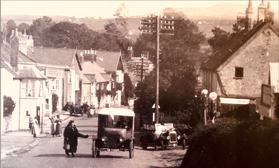
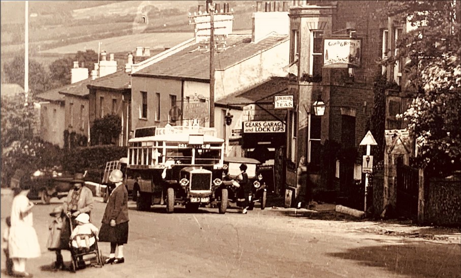
Claud Hider`s photographic postcards are of such high quality that it is possible to enlarge areas of them to provide a detailed study of activity in the background. In this case we see a candid shot of an old lady stopping for a taxi outside Gear’s Garage on the right. A garage mechanic has the bonnet of a car up to carry out a repair. A group of ladies with aprons can be seen outside the George Hotel and in the distance we see another automobile parked on the pavement.
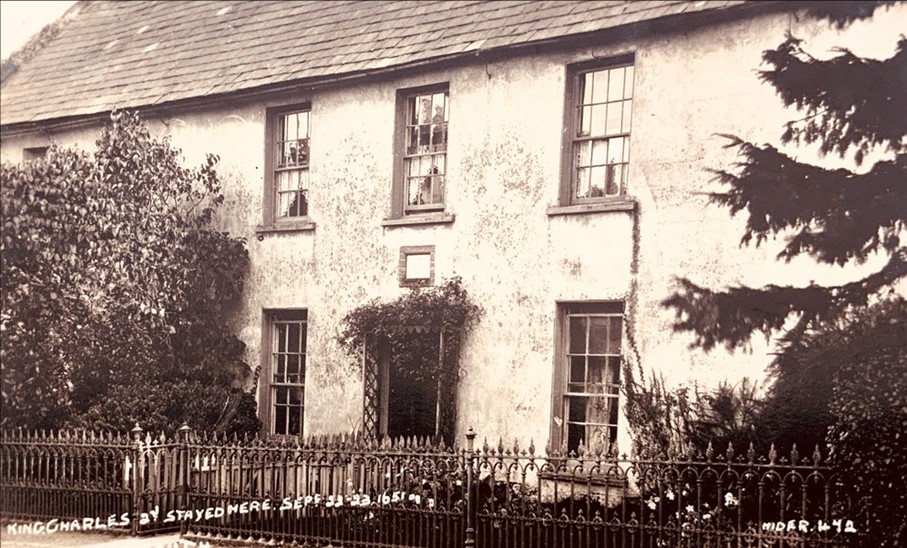
The historic Abbot’s House was built in 1525 by Thomas Chard, Abbot of Forde, for his cousin Ralph Tybbes, who was Steward for the village. The original doorway was discovered during restoration in 1932 and the initials T.C. can still be seen above the arch. In 1651 Charles II stayed there for one night in his attempt to flee the country after the Battle of Worcester. He failed in this in part because the wife of the master of the ship, Stephen Limbry, found out what her husband was up to and locked him in their house. By the time he got out it was too late, and the King had left.
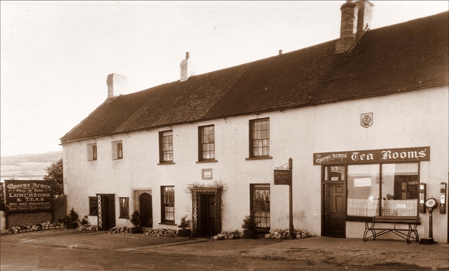
Claud Hider would often return to Charmouth and record changes in the village. He produced this postcard in 1934 for Clifford Stapleforth, the new owner of The Abbots House, then known as The Queens Armes. It had formerly been the Manse for the adjoining Congregational Chapel for over 200 years and he converted it into a hotel. Part of it became a tea room as shown here with extensive gardens at the rear. It remained a popular hotel until fairly recently and has now reverted back to being a private house.
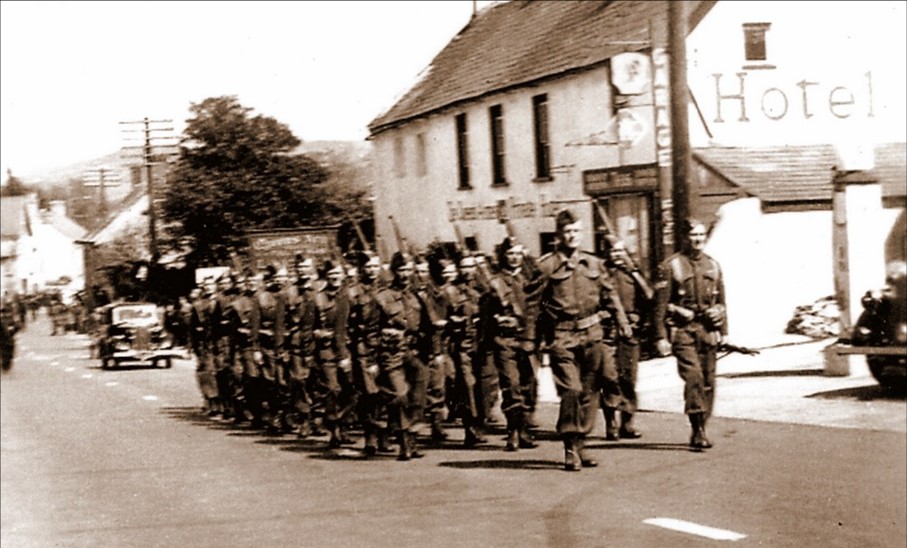
Following the German campaign in Europe in 1940, there was a real threat of invasion of the UK in May 1940. Anthony Eden made a radio appeal to men aged between 16-65 to form a defence force called the Local Defence Volunteers (LDV). The Charmouth unit was formed by the Commanding Officer, Colonel Little, who lived in the house on the comer of The Street and Lower Sea Lane called Sandford. They are seen here marching past The Queens Arms on the right. The following page shows the villagers who formed the Volunteers.
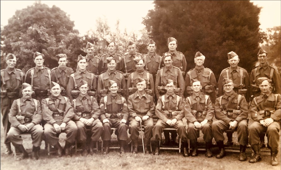
The photograph above produced as a postcard by Claud Hider in 1 942 shows the following villagers from left to right:
Back Row Gear H; Jerrard D; Matthews S; Holman J; White F.
Middle Row Peach H; Frampton, R E; Bartlett, J; Young R.; Havis C Spurdle E ; Loosemore R C; Rendell W; Lane R; Quick F.
Front Row Stirk J; L. Corporal Restorick G; Corporal Frampton R.E.C; Sergeant Aldworth C., Captain Marston S; Sergeant Herbert S; L. Corporal Hodder J; L. Corporal Stokes J; Oxenbury J.
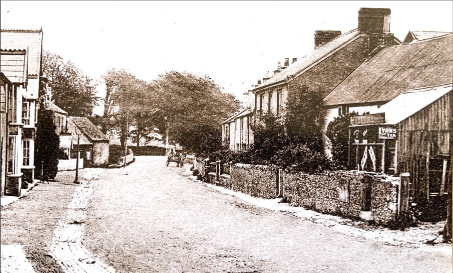
Photos of this end of the Street are very scarce and this is the only one that I have found of the Lilacs and Mintaka on the right. There appears to be a small grocers store called the Match Box in front of the Lilacs at that time, which would be in the 1920s. It had an extensive garden and was the home for many years of Fred Penny, his wife and four children. Mintaka was where Samuel Hansford lived from 1916 until 1920 and was built by Penny in part of his grounds. In the distance on the left by the bridge is the former Mill.
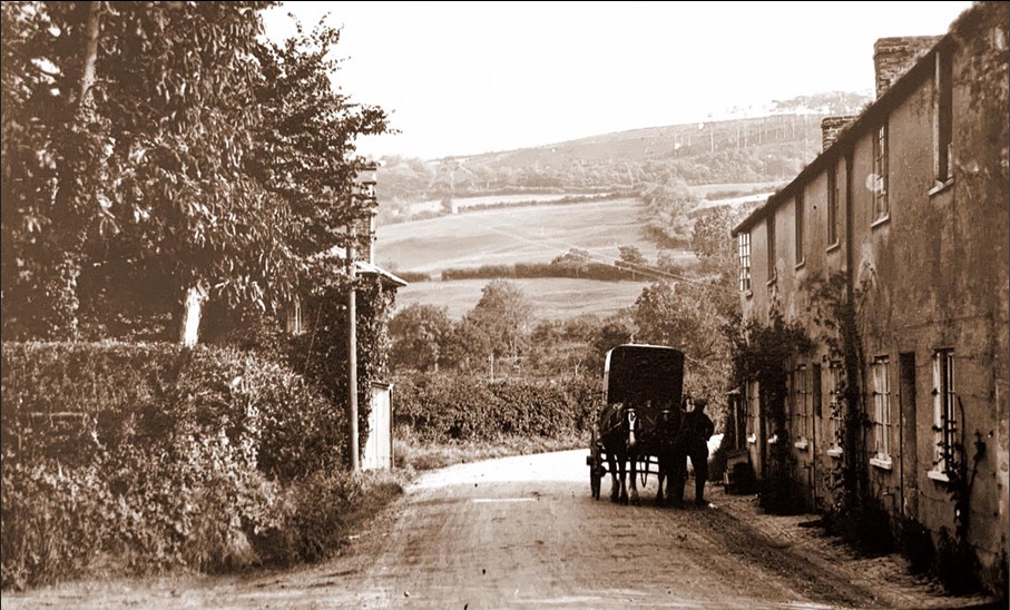
The ivy covered building on the left was originally a Toll House built after 1827 when the Bridport Trust was established. The earlier Great Western Turnpike Trust had been formed in 1757. There is another identical redbrick Toll House at West Allington in Bridport constructed at the same time. The system of collecting tolls for maintaining the road came to an end in 1877 and the Toll House became a residence. On the right are Catherston Cottages which were sold by the Bullen family in 1958 as part of their larger estate.
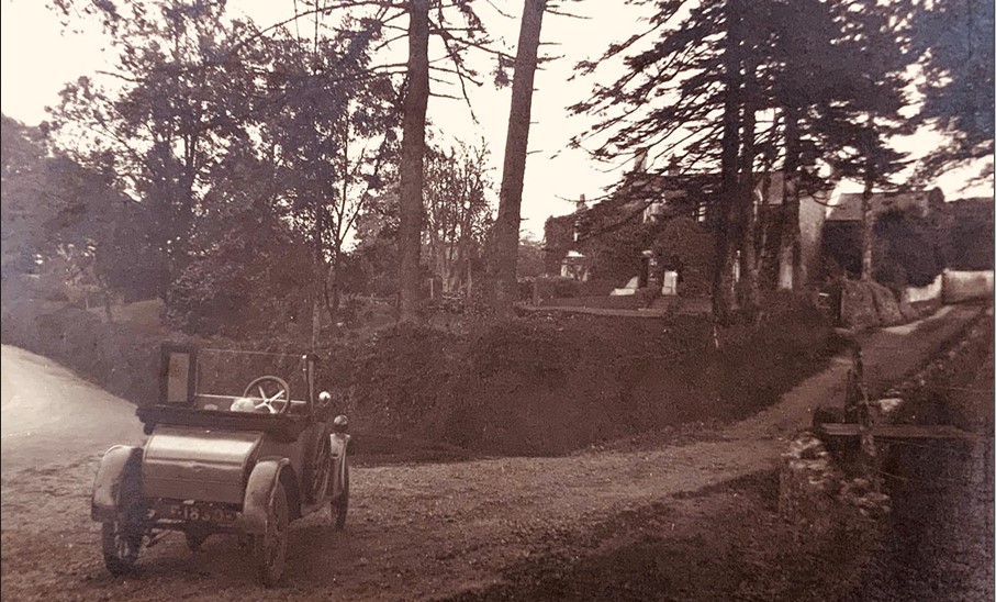
This photograph allows us to get a close up of the Model T Ford that Claud Hider was driving in 1928. It quite often appears in postcards of the time. You can just make out the head of a small child in front of the steering wheel. On the right is the road leading to the steep climb of Stonebarrow Hill. The ivy clad building in the distance is Stonebarrow Manor, which at that time was run as a Girls’ School. It had formerly been called Newlands Manor House and formed part of a separate hamlet dating back to the 12th century.
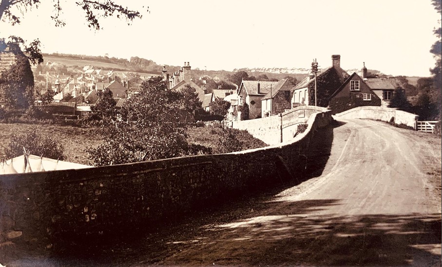
On the right of the bridge are the former Mill Buildings. In 1295 William, Abbot of Forde, required each burgess of Charmouth to have his corn ground at this mill. After the Dissolution of the Monasteries, it was owned by the Pole family of Shute who continued renting it until selling it to Robert Knight in 1783. It was later bought by Colonel John Bullen Symes Bullen of Catherston Manor who installed John Gillingham as miller. In 1957 a new bridge was built by the Mill House and the road level and pavement rose obscuring part of the front.
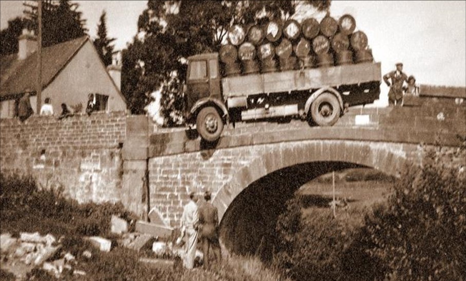
This amazing photograph taken in 1937 is of a lorry piled high with barrels precariously hanging over the former bridge which was later altered and widened in 1957.The old mill bridge was built by the County in 1824 and was one of several bridges which contained the following warning: Dorset. Any person willfully injuring any part of this county bridge will be guilty of felony and upon conviction liable to be transported for life by the Court. T.Fooks. During the war in 1940 when a German invasion was threatened the word ‘Dorset’ was cut out.

A close-up of the bridge shows the T Foolks sign on the right. John Wesley, the founder of Methodism, has a link with Charmouth. His great grandfather was the Rector here. He and his son John lived in a house where Mill View is today until they sold it in 1668. The original deeds show that it had earlier been owned by Stephen Limbry. Bartholomew Wesley was made Rector in 1645 by the Parliamentarians and supported their cause. His time as Rector coincided with the future King Charles II‘s attempted escape by boat to France from the shores of Charmouth in 1651.
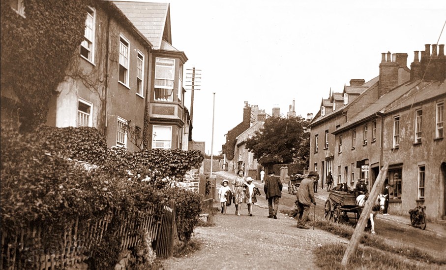
A nostalgic view from the bridge towards the George Inn with a workman repairing the road on the left of Mill View. This terrace was built in 1857 after the earlier ancient house was destroyed in a fire 6 years before. It was let initially to the Admiralty for £100 a year, before they built their own coastguard cottages in Lower Sea Lane. The tall gabled building on the right called Firlands was occupied by Mr and Mrs Toms. It had previously been where the Volunteer Band had their Drill Hall.
Three workmen looking back at us by the side entrance of the gabled house that was demolished in the 1980s to create Barney`s Close at the rear of the Street. The row of cottages was at one time thatched and was once owned by Frank Coles. One day he and John Toms, the miller, drove to Axminster. On the way they discussed the cottages and before they reached Axminster the cottages had changed ownership. Frank Coles was prepared to sell them for £500. On the left is the sign for Bow House which had a tea garden at the rear.
An early view dating from 1922 looking up The Street from Bow House on the right and Grange House on the left. The cobb wall on to The Street is a survival from when walls were made with straw and clay. The road surface seems very dusty and signs of the original cobbled surface is clearly seen at the sides. Bow House has a large sign promoting its Tea Rooms. Both Bow House and its neighbour Stow House were built in 1804 by the sailcloth maker, William Burnard. The sign in the centre for W A Gear - Cars for Hire, was Billy Gear’s first garage.
The first reference to Billy Gear is in the Kelly’s Directory of 1923, where he is described as a Car Hirer. He garaged his vehicles in the two sheds owned by Harold Pryer, the stone mason, on the east side of a narrow lane alongside the butcher’s shop at Devonedge. The business prospered and his next move was to stabling at the rear of the George Inn. This is a delightful old postcard of him with his mechanics standing proudly alongside his two taxis. He is sporting a bow tie, which was to become his trademark.
Charmouth is very fortunate in having today one of the oldest continuously run inns in the country. The George has a remarkable history stretching back to the Middle Ages when the village was owned by Forde Abbey. The dating of the building, based on the roof timbers, as 16th century would confirm its ownership and construction by the monks. It’s deeds date from 1702 when James Dober paid £60 to John Burridge for a 1000-year lease. At the time of this photograph the Landlord was Frederick White. The stump of the large overhanging sign can still be seen today.
The building on the left, Sunnyside now known as Devonedge, was run as a bakery and tea room by the Cole family with a hotel on the upper floors. The photograph was taken in 1928 and shows the garage operated by Charles Woolard that stood in the forecourt of Lansdowne House. At that time the village had two garages facing each other. The ivy clad building next to it was the Wander Inn which had formerly been known as the Rose and Crown, with records now held the Exeter Record Office dating back to 1561.It was demolished in 2003 and a new building erected.
Another wonderful photograph of the towering Devonedge Hotel taken by Claud Hider in 1928 from the grounds of Harry Pryer’s masons yard. The hotel was built on the site after a disastrous fire in 1895 had destroyed a group of buildings as far as Barr's lane. It had a somewhat chequered history as a hotel and was later divided into apartments and shops. The shops were not built until 1934 on the site of one of the buildings lost in the fire. The carved ship’s figurehead in the centre was washed up on the beach and placed in the grounds of the workshops.
A fire in 1895 swept through three large houses and completely destroyed them. Two plots were quickly rebuilt as Sunnyside (Devonedge) and Lansdowne House. The other, owned by Harry Pryer, was left as a garden (shown on the left) which led up to his house at the top of Barrs Lane then known as Lane End. It was auctioned the year after his death in 1931. Clifford Stapleforth paid £370 for this lot and £250 for the parcel of land opposite, both of which were later developed into shops and houses.
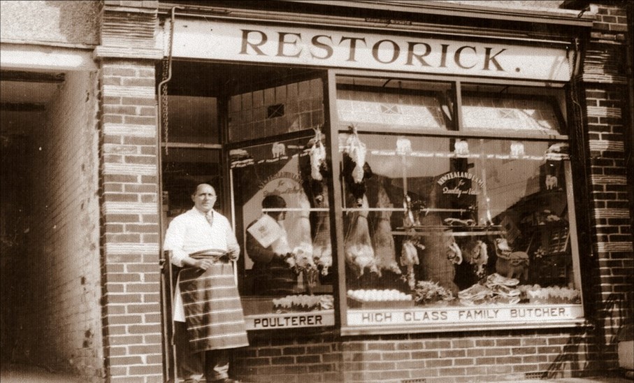
George Restorick is seen here proudly standing in front of his shop. He was originally from Axminster and earlier had a butchers by the Grange garden, opposite the George. He was one of the first four occupiers of the newly built shops in 1934. He was there until the 1960s when Morgans took over the shop and later extended into Child’s shop, which is why today they still carry a large DIY stock at the back. During the war George was a member of the Home Guard and appears in their line up photograph taken by Claud Hider in 1942.
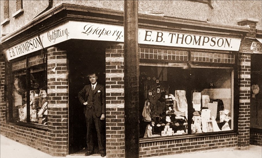
Ernest Thompson standing in the doorway of his drapers shop on the corner of Barrs Lane and The Street. It was he who submitted plans for four shops. Ernest was to take the corner building for himself and opened it in 1934 as a drapers shop which he ran with his wife Ethel. Andrew Dunn took the next one as a jewelers. Harold Smith ran his bakery from the next shop and placed a large gold Hovis sign above his door. Finally, George Restorick took the fourth unit. Thompson was to be there into the 1950s, Smiths and Restorick into the 1960s.
On July 12th 1895 Charmouth suffered its most disastrous fire. It began in a thatched roof and by the end of the day, three large houses were completely destroyed. They formed a group and it was only the gaps between them and their neighbours that prevented the fire from spreading further. On that day Charmouth was to lose many historic properties. The most important of these was the one known as Streets which occupied the site on the corner where the four shops are today.
This old photograph is of young school children outside the building known as The Limes, though now Charmouth Lodge situated on the corner of Barr's Lane. It would have been originally one of the workshops of the sailcloth maker, Jacob Ridley Kitt who lived next to it in Little Lodge. Richard Whittington was to move to the village with his wife and family in 1900. He was a direct descendant of the real-life hero made famous in pantomime. Their time in the village was short, and he died in 1906 and his wife five years later. It was their daughters who subsequently made their mark, opening a school next door and being involved with the tennis club.

This is a wonderfully candid photograph Claud took looking down The Street in 1922. William Dampier’s grocers shop is on the left. Next to it is a sign for The Star Inn, which stood at the end of an alleyway. The other side of it was Little Lodge with its high hedge. Further on are the tall lime trees that gave the house its name and which is now known as Charmouth Lodge. To the side of it was a garden on which four shops were to be built ten years later. Devonedge, then known as Sunnyside towers above its neighbours. On the right of the picture is a young lady with her child in a push chair next to Fred Marsh`s delivery van alongside his butchers shop at Winton House.
Charmouth Stores is one of the oldest grocers shops in the country. It was established in 1807 by Joseph Bradbeer initially as a Post Office. After his death it was run by his wife, Lydia who sold it in 1833 to John and Wilmet Carter. Their son John later took on the business until 1864, when a devastating fire tore through the group of thatched properties. They were rebuilt by Giles Pryer and James Hawkins bought the shop. He was here only briefly until selling to George Mortimer who greatly extended the range of goods that it sold. It then went through the ownership of Edward Vince and John Baker before being bought by William Dampier in 1919.
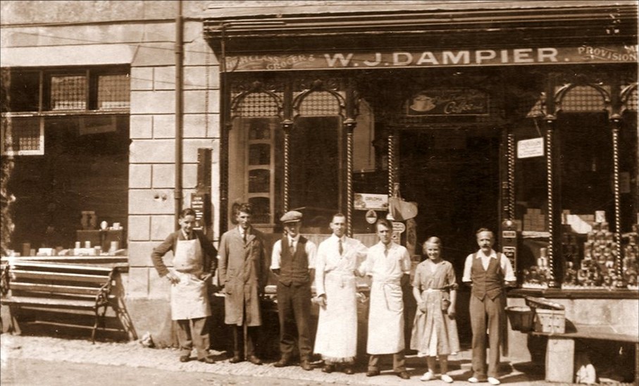
Charmouth Stores went through a period of decline under the ownership of John Baker until it was bought by William John Dampier in 1919. He had moved from Dorchester where he worked for the department store of Boons and Sons. The Directory shows their telephone number as just 4 at that time. This photograph from 1935 shows William with his staff. From the left it is believed that the people shown are Percy Larcombe (young assistant who lived next door), Cecil Bugler (assistant), Sammy Smith (delivery man), Peter Aldworth (provisions), Donald Hubert Dampier (son), Gladys Frampton (daughter), William John Dampier (owner).
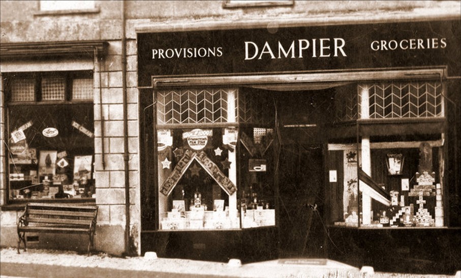
The photograph shows the new shop front that can still be seen today. G K Chesterton of Father Brown fame was a frequent customer at Charmouth Stores. One of the verses he was famous for was The Wicked Grocer, which reflected badly on the trade. But after the impeccable service he received from the Dampiers in 1929 he penned a new verse which he dedicated to William called The Good Grocer that is full of his praises. After William Dampier’s death in 1955 it was taken over by his son, Donald and later by Ron and Jean who continued to run it until the year 2000. It is now known as Nisa and is run as a family business by the Trittons.
This superb photograph of members of the Pryer family outside Stanley House where they had lived from 1841. In the picture are Lily Coleman, Ellen Pryer, Pauline and Geoffrey Coleman with Peter (Lily and Geoffrey’s infant son). The house was one of a row of four rebuilt by their ancestor Giles after a disastrous fire in 1864 and called Prospect Place. It was his son, Harry, who was to continue his business. Next door is Rupert House with Charmouth Stores at the end.
In 1870 Mary Stuart, who lived at the Court, bought Backlands Farm at the rear of The Street. When she died two years later her estate went to her unmarried daughter Catherine, who retained it until her death in 1891.It was during her ownership that the substantial house at the front was built and now consists of two parts, Harding and Backlands Farmhouse. It is where William Norris and his family would live for nearly 30 years. On Catherine Stuart's death, the farm passed down through various members of the Schalch family until It was bought by Frederick Jolliffe who had his dairy there, and where villagers were able to buy their fresh milk.
This photograph shows clearly two of the three ivy clad houses that formed Hillside Terrace. Joseph Wilson, from Lyme Regis chose to demolish two former cottages and replace them with three fine identical Regency houses with large gardens set back from The Street. He instructed Sir Jeffry Wyatville as the architect, who was famous for the work he carried out at Windsor Castle, Chatsworth and other stately homes. The work was completed in 1824 and a number of famous people were to reside there in due course.
The long, shuttered, wisteria-covered building filling the view is The Court, which is directly opposite the War Memorial and at that time was occupied by James Schalch. His sister Alice was married to Alfred Haggard, whose brother, Rider Haggard, author of King Solomon's Mine was a frequent visitor at The Court. When he required names for two of his characters for the novel She written in 1886, he chose Leo Vincey after Edward Vince the owner of Charmouth Stores and L Horace Holly after William Holly, the owner of Langley House.
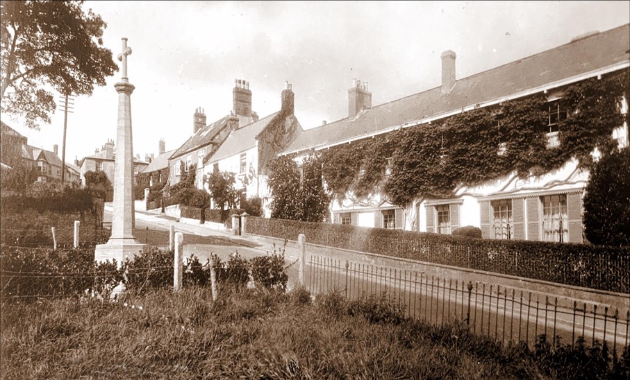
The house in the foreground now called Monks Rest, had formerly been called Sycamore Cottage. A Mrs Watson was living there when this photo was taken in 1927. One can just make out the outline of The Court, its neighbour behind all the trees in its front garden. On the other side of The Street is the wall of Charmouth House and then the War Memorial which was made by Harry Pryer from the local ham stone and erected in 1922. The bronze plaques surrounding its base record the tragic deaths of villagers lost in both World Wars.
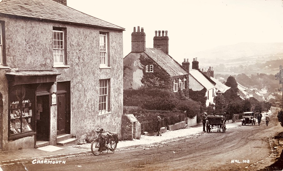
This is one of the earliest postcards Claud Hider issued when he was in partnership with Henry Lawrence in 1922 and had the initials H & L inscribed on the negative with the number 108. The little stationers shop run by Miss Elizabeth Tarr shown in the foreground no doubt was an outlet for this and other cards that he produced. Elizabeth was to spend over 60 years at Portland House and Reginald Pavey mentions that after her death in 1939 he had the job of sorting it out and found stacks of old newspapers piled high there which had never been returned. The shop, which no longer exists, formed part of the larger Portland House.
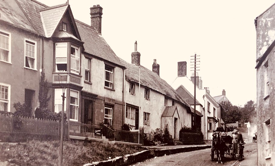
This wonderful postcard dated 1922 shows some of the businesses in this part of The Street at that time. At the top can be seen The New Inn, then the fish shop run by Cecil, brother of Billy Gear. The village GP Alfred Barratt-Hine lived at Askew House. At Melville House was a stores run by Wilfred Smith. Next door at the rear of Waterloo House, Alfred Childs had his hardware store (now the fossil shop). Frederick Hutchings, was a cobbler living and working from Granville House on the right; the window to this former shop can still be seen today. In the foreground is Claremont House, which at that time was a guest house run by Alfred and Hannah Hodges.
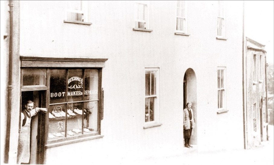
Fred Hutchins is shown here with his wife, Mary at their shoe shop which formed part of Granville house where they lived. You can still see the shop, but it has long since closed. Fred moved into the premises in 1920 and continued to live there until his death in 1970. He was a postman, fireman, parish councilor. One Christmas Eve in the 1880s the building was destroyed by fire. Its owner, William Potter was carried across the road and seated on a chair, watched his house burn. The house was rebuilt by the insurance company and the next tenant was William Copp, a tailor. After he left, the house was purchased by Fred Hutchings, bootmaker, and was later inherited by his son Ernest.
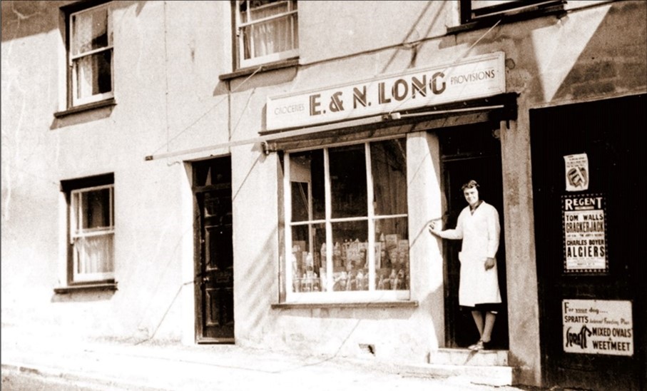
Longs was a store in part of Melville House. It had opened in 1937 as a grocery business and was in time the village Post Office. Nora and Ellis Long were very active in the village for over 30 years and during the war Ellis was an Incident Officer with the Civil Defense Corps. The poster on the right for The Regent Cinema was one of many produced by Ellis to advertise local events. It advertises the film Crackerjack which was released in 1938 and helps date the photo. You can still see traces of the original shop which closed many years ago in the frontage of Melville House.

The lady seen in the foreground is in the doorway of the Holt, which at that time was a shoe shop. In 1931, Billy Gear’s brother, Cecil opened his fish shop there. His trade was seriously affected by the shortage of fish during the 2nd world war, and his life was tragically cut short in 1944 at the early age of 48. On the other side of the street is a lady standing in the arch in a wall that still stands and leads into the garden of Melbourne House; she may well be Mrs. Mary Knott who lived there. A little further down the Street was Bruton House where Francis Davies lived. It was later renamed The Well Head when the famous local historian Reginald Pavey retired there in 1926.
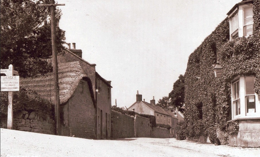
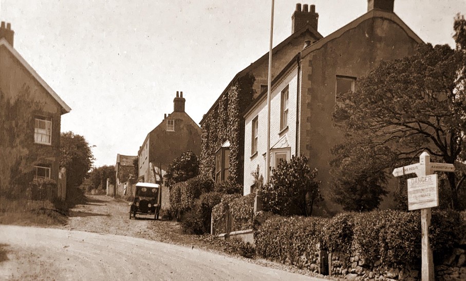
This view captured by Claud Hider in 1923 shows the junction of the Axminster Road with the Street. At that time, Harry Wild was living in the old Thatched Cottage on the left. After he died it remained empty and was finally pulled down and the site was used as a car park. Eventually the road was widened, and the neighboring cottage was also to disappear, and the bus stop is now on the site. The large sign on the corner is warning motorists at the time of the danger of a cliff fall, which caused the eventual disappearance of the road. The Ivy clad building on the opposite side was the New Commercial Inn.

As with many buildings that Claud Hider was to photograph in Charmouth, the New Commercial Inn was smothered with ivy. The building you see today replaces an earlier thatched inn that was completely destroyed in January 1888 together with its neighbour, a grocers shop . The landlord was Henry Wild and it was not until 3 years later that the new building was completed. Henry Wild continued as the landlord and the 1911 Census shows him aged 62. Eventually he was in partnership with William Hambridge from 1921. The hotel was eventually closed by the brewery and divided into three properties (Grosvenor, Charleston and Heron Cottages).
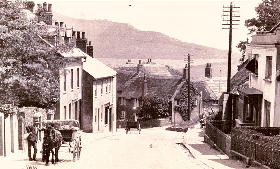
This postcard dating back to 1923 shows the junction of the Street with Old Lyme Hill and Old Lyme Road, which led through the Devils Bellows. The Old Lyme Road was cut in 1825 as a link to Lyme Regis, as the old Roman Road was steep and hazardous. The cliff below Charmouth Cutting had been slipping for some years. When it eventually gave way the fields above the Cutting gradually disappeared. Finally, on 26th May 1924, the road was closed to all traffic, after a further landslip. The sign on the right warns motorists of the dangerous state of the collapsing road.
In our imaginary tour taken by Claud Hider a hundred years ago we have crossed over to the other side of The Street and now view the photos he took which were published by him as postcards. The gabled building on the left is Claremont, formerly known as Knapp House, which was a popular guest house run by Alfred and Hannah Hodges. Above it is Badgers, which was then occupied by George Grinter who ran Foxley Farm, with its fields stretching from Old Lyme Hill to Higher Sea Lane. Bruton House and Melbourne House are above it.
The large thatched building seen here in the centre at the corner of Higher Sea Lane is very ancient, with a history stretching back to times when the village was owned by the Abbot of Forde and it was a hostelry for weary travelers. It was called the Fountain, after the stream that passed it and which still exists along Higher Sea Lane. The hostelry closed its doors in 1811, although later in the century it reopened as a hotel run by George Holly, who renamed it Charmouth House. This eventually closed in 2005 and was split into four dwellings.
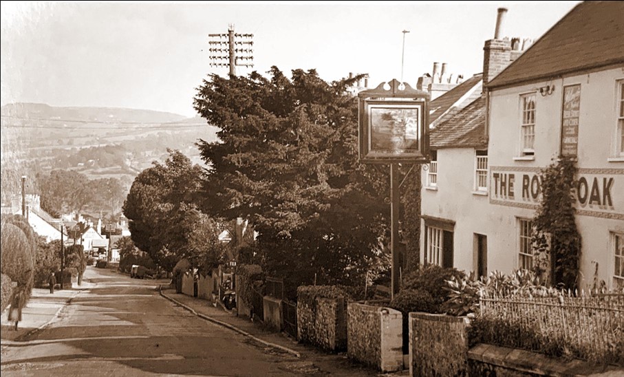
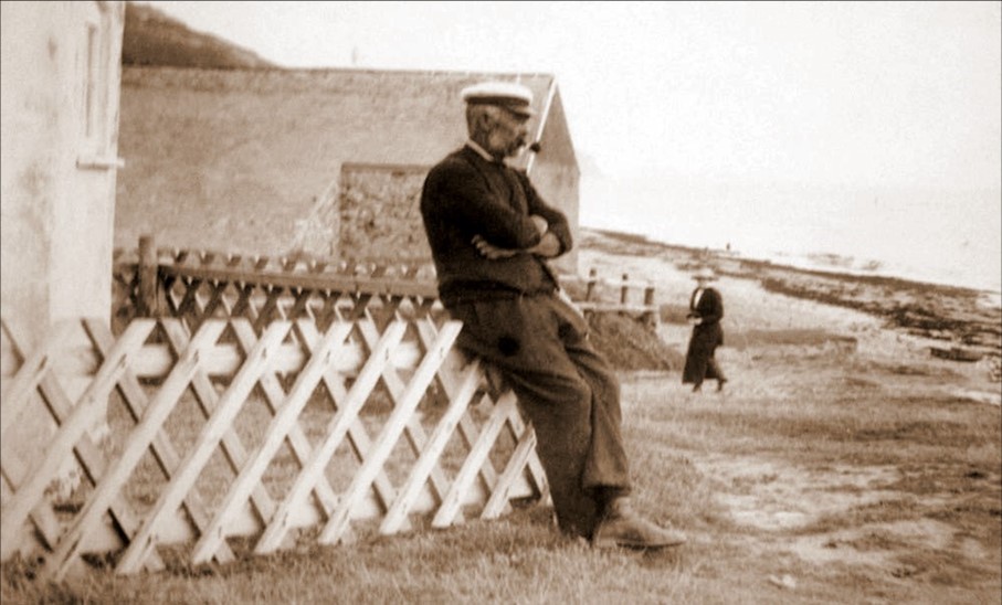
Claud Hider produced another view of the Royal Oak a few years later. At this time the landlord was Jim Bridle. He retired in 1934, but continued to live at St. Helena in Higher Sea Lane before his death in 1953. His daughter married the successful garage proprietor and entrepreneur, Billy Gear. Jim was born in Lyme in 1870 and went to sea when he was eleven joining The Royal Navy four years afterwards. He was made Leading Seaman in 1892 and Chief Petty Officer in 1902. He served in the Navy for twenty five years.
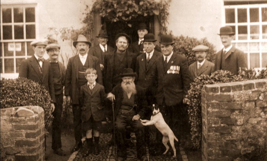
This photograph of a group outside the Royal Oak on Remembrance Day in 1925 shows a number of members of important village families at that time.
Back Row: Alby Cook, Andrew Dunn, Jim Bridle - Landlord, Charlie Larcombe, Shane Burridge
Middle row: Billy Gear, Reg Rattenbury, Bill Gordge, Ted Hunter, Fred Hitchcock
Front row : Jim Bridle Junior, John Hodder, familiarly known as ‘Scutter’ & Boy, his dog
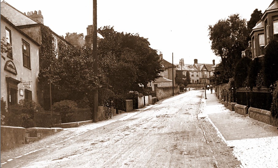
Langley House on the left formerly housed the Post Office and was then known as Wistaria. Edward Day, the famous geologist who worked with Sir John Hawkshaw on surveying the first Channel Tunnel and other projects, lived here from 1861 to 1865. Above it is the ivy clad frontage of Little Hurst which was owned by Lord Herbert, who in 1857 opened a convalescent home there with 20 beds and a resident matron. His friend Florence nightingale attended the opening ceremony.
In 1896 after ninety years in the same premises, where Nisa is today, the Post Office was taken over by William
Holly and moved further up the Street to Wistaria House, where it was to be run by the father and his son, William Jnr. for the next 40 years. When the father died in 1931, the son opened part of it as a stationery shop. William Holly
junior finally retired from the Post Office and its next move was in 1939 to the top of The Street to Melville House. The outline of Little Hurst, now the local Surgery can be seen behind the high hedge further up The Street
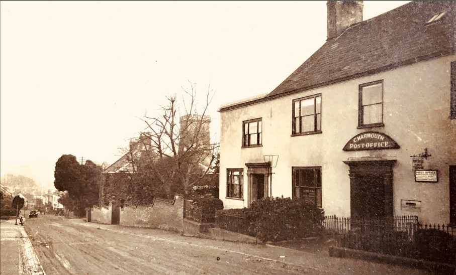
It was William Holly who would sell the many views of Charmouth that Claud Hider produced from the Post Office seen here. On the left is an annex that was built and let to a branch of the Wilts and Dorset Bank, which later was taken over by Lloyds Bank. In due course they moved to the bottom of the Street in a premises that is The Bank House Café today. On the left is the extensive garden of the Elms whose ivy clad frontage can just be seen. This is an ancient building which houses the Parish Council offices today.
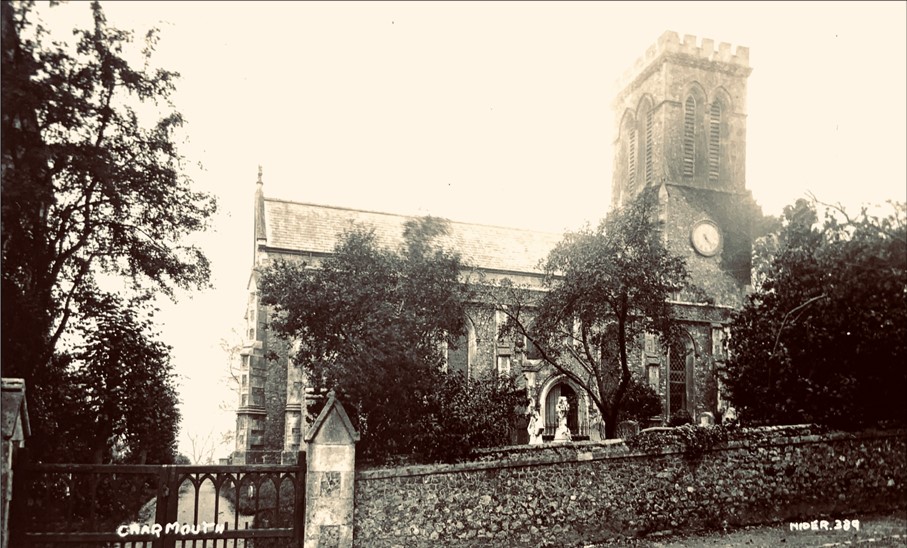
The Reverend Frederick Markby was the rector of St. Andrew’s Church in 1923 and lived at the rear of the Church in the Rectory. The Church replaced an ancient building which was demolished in 1835. Near the entrance to St. Andrew’s Church is the once imposing tomb of James Warden, recording his many sea battles and his tragic death in a duel in 1792. It is one of a number of memorials still remaining both inside and outside the Church commemorating the many important individuals who have played a part in the village's history.
It must have been depressing news when the village was told in 1835 by Charles Wallis of Dorchester, architect, that he had never seen so dilapidated or unsafe a building, and that it was necessary to build a new church. However, the whole village worked with enormous energy to raise the money. The architect chosen to design the new Church was Charles Fowler, whose mother, Jane lived with her sister Lucy at Little Hurst, which is now the Doctors’ Surgery. He is famous today for designing the popular Covent Garden Piazza and many other churches and markets.
The former Coach and Horses can be seen in the centre. In the past it was the focus of the important coaching trade that passed through Charmouth. It was here in 1803 that Jane Austen stayed and later wrote highly of the village in her novel Persuasion as ‘Charmouth, with its high grounds and extensive sweeps of country, and still more its sweet, retired bay, backed by dark cliffs, where fragments of low rock among the sands make it the happiest spot for watching the flow of the tide, for sitting in unwearied contemplation’ The building we see today replaced a much earlier inn that stood on the same site until 1882 when it was destroyed by fire.
A line of taxis is seen here in 1926 in front of Billy Gear`s Garage which used the former stables at the rear of the Coach and Horses. He was only there briefly before moving further down The Street where he built permanentpremises. Sidney and Lily Boucher were the owners of the hotel in that year. Their son Montague was tragically killed aged 30 during the second Battle of the Somme in 1918 and his name is one of those recorded on the village War Memorial and the Book of Remembrance in the Church.
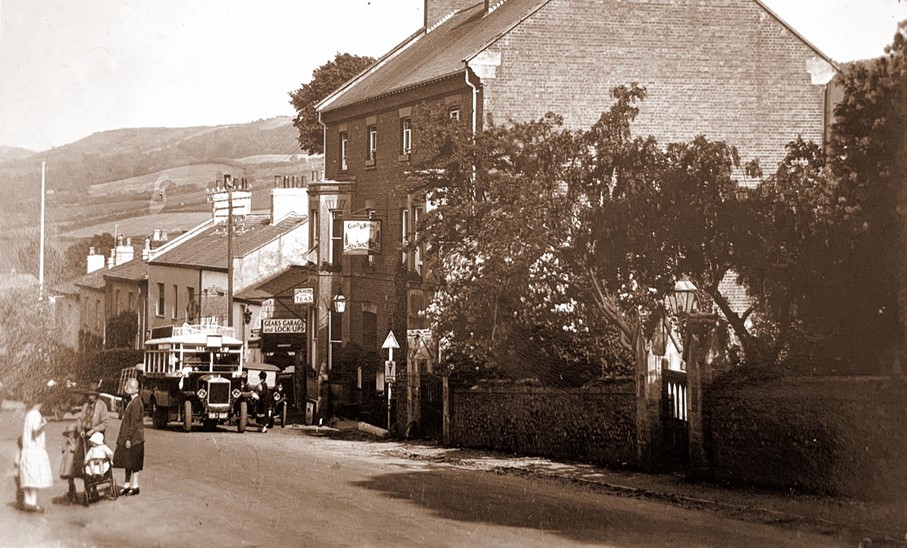
This magnificent postcard is a wonderful record of a long lost era in Charmouth’s history when in 1926, it had a flourishing butchers, garage and hotel next to each other. The young boys standing outside the doorway that led to the abattoir at the rear are the sons of Frederick Charles Marsh, whose shop window filled with meat is behind them. He was there until 1938 when it was bought by Reuben and Ron Frampton who ran this shop until 1961 when they sold the business on to Bright. Billy Gear can be seen at the garage entrance wearing his cap and bow tie, in one of his vehicles which he hired out from the former stables of the Coach and Horses.
This postcard from 1924 is full of activity showing a group of ladies with their young children in their stylish clothes and bonnets, standing in the road on the left and a bus waiting for passengers outside the Coach and Horses. The route run by Southern National Omnibus Company took it from West Bay through Lyme Regis to Axminster, equivalent to the X31 today. Below the hotel were Gear’s Garage, Winton House, Beech House, Carrum House, Littlecote and Sandford House. The latter was demolished in 1958 to widen the narrow entrance to Lower Sea Lane.
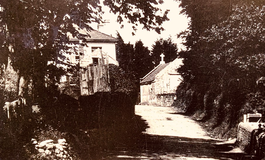
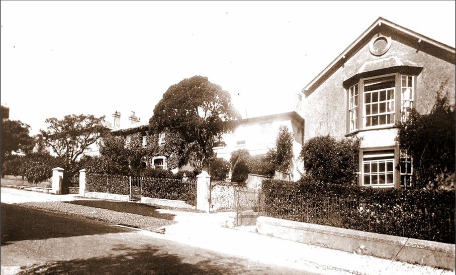
This photograph taken in 1923 shows how narrow Lower Sea Lane was at its junction with The Street. The large building on the left was Sandford House where Colonel Little lived. On his death in 1958,it was purchased by Dorset County Council and pulled down to improve the entrance, to Lower Sea Lane. It had been one of three almost identical regency properties. With Littlecote and Carrum House further along, they formed a group of three villas built between 1843-5 by Samuel Dunn and his son-in-law William Hoare. The gabled building on the right with a stone cross was Harry Pryer’s stonemasons workshop which today forms part of The Pharmacy.
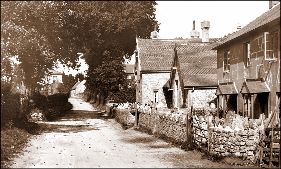
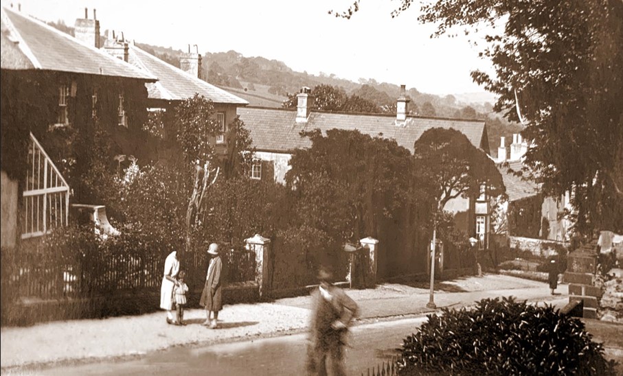
On the right of this photograph are the Almshouses that were built in 1867 and paid for by Mrs. Napier Stuart who lived at The Court. She wished to demolish the original almshouses founded in the 17th century by Anthony Tutchen in order to build a coach house on its site next to The Court. The old Village School can be seen here in the centre, with children in its small playground. The foundation stone for the new school was laid on 26th August 1869 by Mrs Breton, the rector's wife. In 1992 the school was rebuilt at the bottom of Lower Sea Lane and the old building converted.
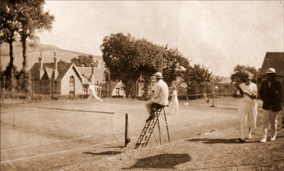
The Tennis Club was originally entitled The Charmouth Private Lawn Tennis Club and was founded early in the 1880s. Reginald Pavey and Major-General Elliot of Fernhill were central to creating the club, initially as a croquet lawn, tennis being played after the needs of the croquet members had been met. It had the most select membership: only the landed gentry, professionals such as doctors, lawyers and the like were accepted and so it remained until the 1950s when it was opened to a wider public. In the background can be seen the village school which stood opposite.
This is an enlargement of one of the views Claud Hider took of Lower Sea Lane in 1922. In the foreground are the Coast Guards Cottages. Behind it is the Church Hall (now the Community Hall) and on the right is the Village School. The Coast Guard Cottages were built by Richard Hodges and leased to the Admiralty from March 1878 for 21 years at a rent of £50 a year. The former inn, which originally stood here, became number 1 in the terrace and the skittle alley, which was against the south wall of the garden, was removed apart from the end portion by the lane which was used as the coast guard's armoury.
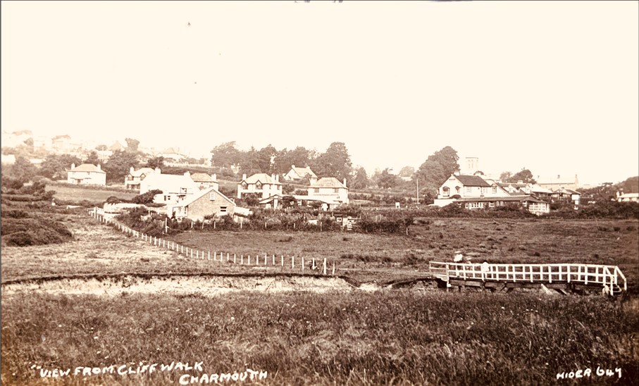
A view looking towards Lower Sea Lane across the River Char. In the background is Hammonds Mead, built by Miss Gertrude Evans. On the horizon on Old Lyme Road you can see the long outline of Downside. The nearest house in the foreground is Sea View, where the Hunters, a local fishing family, used to live. Robert Hunter built the house on a piece of ground that was formerly The Potato Plot. He smuggled freely as did all fishermen and long shoremen of their time. He had five sons and five daughters. Once he was nearly caught by the press gang, but escaped by hiding in the roof.
This is an early photograph taken in 1934 soon after the Wayside Tea Gardens and Café were open by Harriett Forty. Her husband was the landlord of the Coach and Horses at the time. They stood at the bottom of Lower Sea Lane. and offered homemade cakes and dainty teas with views over the sea. Its name is commemorated in Little Tea Gardens, a development of flats that stands on the site today. Behind it are the five houses, Orchard End, Pembroke, Tideswell, Bracoden and Broadlands, built in 1924 by Clifford Stapleforth. In the distance is Sea Horse House which was built in 1801 for the Rev. John Lucy. It later became a hotel which was demolished in 1991 and rebuilt as flats.
This postcard was published by Claud Hider in 1925 and shows the bottom of Lower Sea Lane. Sea View, where the Hunters lived, can be seen in the foreground and then the Wayside Tea Gardens and Café. The galvanised tin roof buildings were known at the time as Tin Town, built as cheap rentals after the First World war. The area was looked down on for a long time by villagers. The earlier bridge across the River Char can be seen here before it was replaced in 1930.
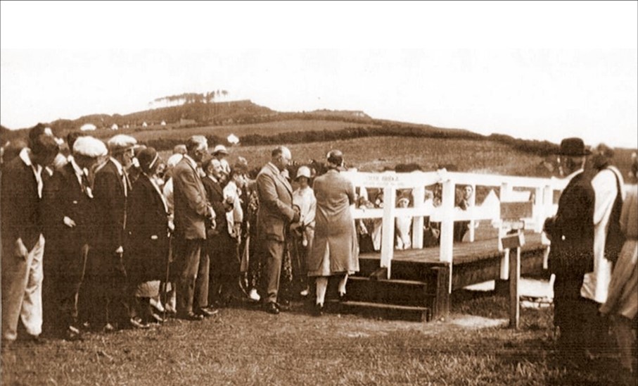
Mrs. West is seen here in 1930 opening the new footbridge over the River Char, which was only recently replaced after many years of service. An estimate of £310 was made by a Bristol firm, but John West considered this excessive and suggested building one with local labour. He, Fred Penny, the carpenter, and others set to work and the bridge was built for £193, thereby saving the parish over £100.
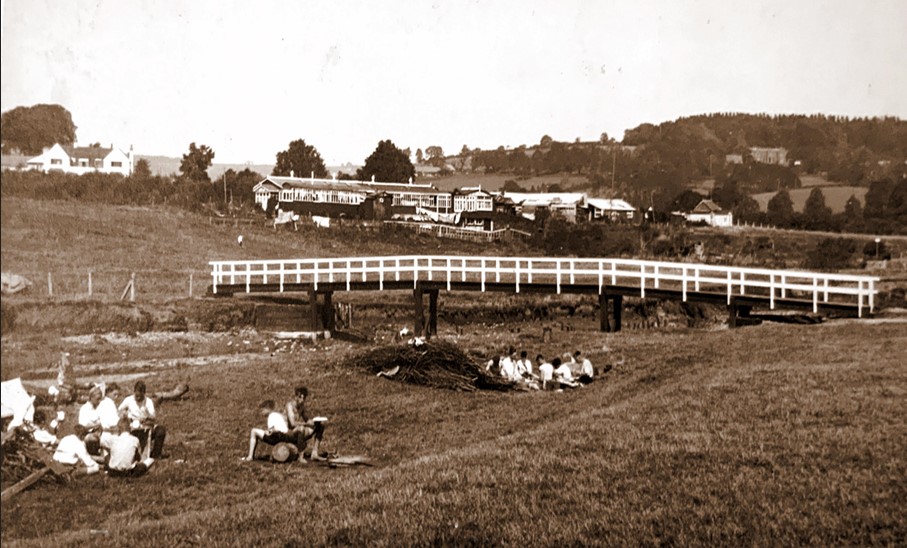
At the beginning of the 20th century almost all postcards of views of Charmouth would include a scattering of scout tents. The local historian Reg Pavey, who had been Head of Clifton Preparatory School in Bristol, was instrumental in bringing the scouting camps to the village. A group of boy scouts can be seen here relaxing by the footbridge. In the background is Tin Town, the row of shacks which has long since been demolished.
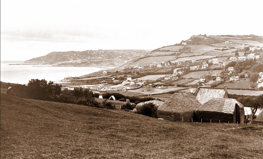
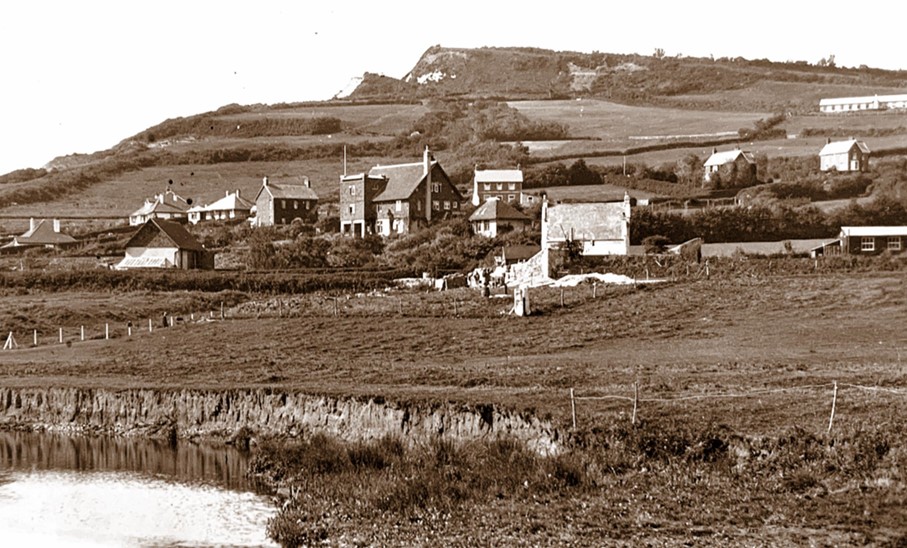
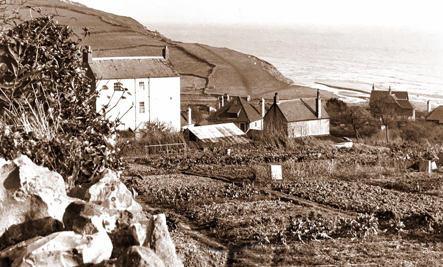
Another wonderfully detailed view of the village taken from Cains Folly by Claud Hider in 1926. Stonebarrow Farmhouse with its associated outbuildings and barns can be seen in the foreground. Houses are scattered amongst the fields which would later be built upon after the Second World War. On the top of the hill seen in the distance is the Devils Bellows, which derived its name from the strength of the wind rushing through the gap made by the Old Lyme Road after it was cut through in 1826.
The entrepreneur George Frean commissioned the construction of the Cement Works near the existing Lime Kilns by the mouth of the River Char and the sea. His sister Anna Frean had married Michael Morcom. With a background in quarrying the Morcoms were ideal candidates to run a cement factory for George. By January 7th,1853 the building we see today had been finished by the local builders, Pryers. Unfortunately, the business wasn’t a success and in 1864 George sold his estate to John Hawkshaw for £6000, and the factory was closed forever. The postcard is dated 1923, which is the year that the house in the background named Thalatta was under construction.
This photograph taken the following year shows Thalatta completed. The owner was a Miss Grace Icombe who had bought for £150 an acre of land from Douglas Pass, the Lord of the Manor of Charmouth in 1922. She took a £500 mortgage from the Portman Chapel Temperance Building Society on the 4th October 1923 to finance the building of her house, which she named Thalatta after the Greek word for the sea. She had the house built as a place to look after wounded soldiers coming from her hospital in Ealing. They would come down by train to Axminster Station where they would be picked up and taken to Charmouth to recover.
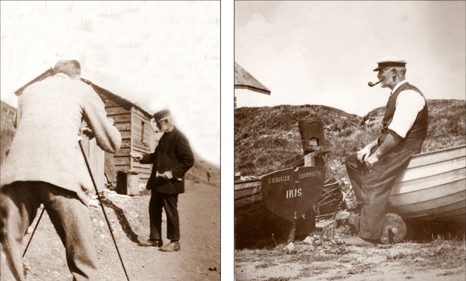
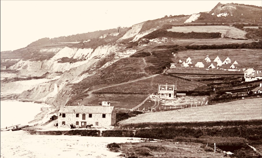
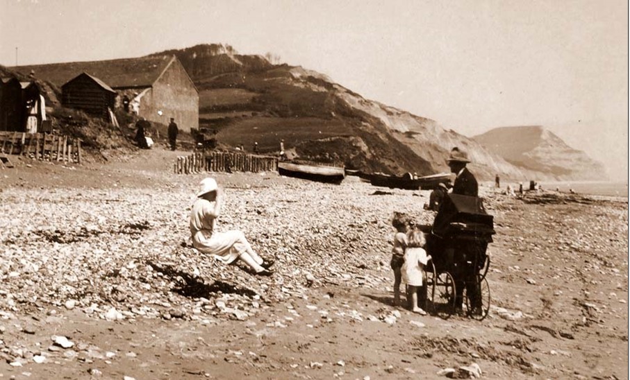
This photograph was a wonderful find as it clearly shows Claud Hider using his camera in 1923 to take a photograph of local fisherman, Tom Hunter on the beach at Charmouth. The shed behind him was from where Tom would work giving out tickets for his tents and deckchairs. The other photograph shows Tom leaning against his fishing boat. In the background can clearly be seen the outline of the Old Lookout, which still stands above the beach today.
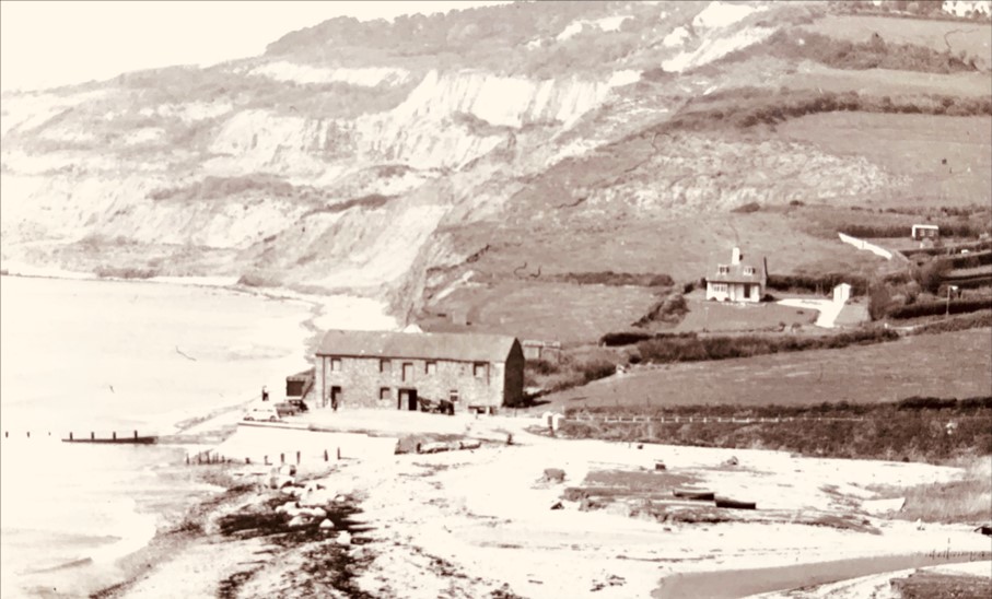
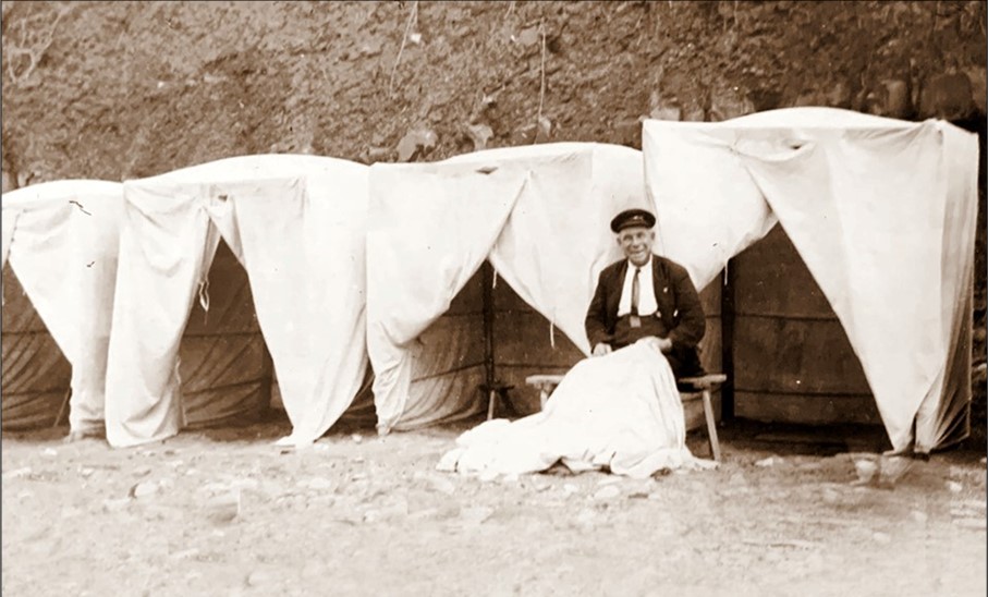
This photograph is another of Tom Hunter. When his brother Wilfred gave up renting bathing machines, he became their owner. It was the custom in the 1880s and 1890s for ladies to bathe from the beach. There was no mixed bathing, and Tom was often known to ask gentleman to move away from the machines when ladies were bathing. As the number of visitors increased, tents supplemented the machines. Tom manufactured these himself during the winter months, and later on he made a few huts. For many years he was a familiar figure on the beach and was known to many visitors as it's first custodian. He died in 1936, aged 79.
Ted Hunter is seen here in his role as Beach Attendant – a position he held for many years. He was born in 1886 to Tom and Jane Hunter and served in the Royal Navy from 1904 until 1919. His record of service reveals a long list of vessels he served on. He looked after the bathing tents and deck chairs for Charmouth Council until his death in 1952. He resided at Beach House in Higher Sea Lane with his wife Ellen.
A postcard produced by Claud Hider showing Girl Guides from Wyke and Abbotsbury at the former Cement Works (now the Heritage Centre) in 1923. They camped in the upper storey of the old building.

A candid shot of a family in 1926 on the beach near the old Cement Works, before the foreshore promenade and concrete steps were built. The view has changed dramatically since then with the addition of lines of beach huts. During the spring of 1954 severe gales damaged the concrete walls so badly that they had to be entirely rebuilt. The outline of Golden Cap can be seen in the distance.
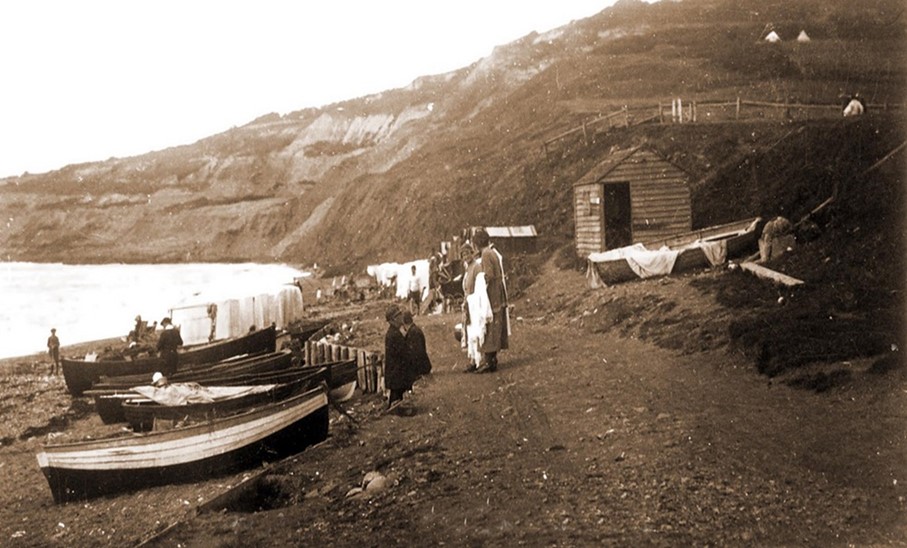
The Beach on a summers day in 1922 with visitors enjoying the waters. There were still a number of men fishing along its shores. They used Lerrets, which were double-ended with a high stern post to enable them to be launched off the steep beach and hauled up onto the beach to catch Herrings. In the distance are the Tents and Beach Huts that the Hunters would hire out from their shed.
An early photograph of the newly built beach huts. Above it stands the Lookout which was built in 1804 when lookouts and signal posts were constructed all along the south coast during the Napoleonic Wars. However, the invasion never came. During the first half of the 19th century, the Lookout was used very effectively by the Excise & Coastguard Service looking for smugglers. In 1909, its use as an observation post was discontinued, and in 1945 the building was given to Charmouth Parish Council. It now continues its original role as a lookout staffed by volunteers.
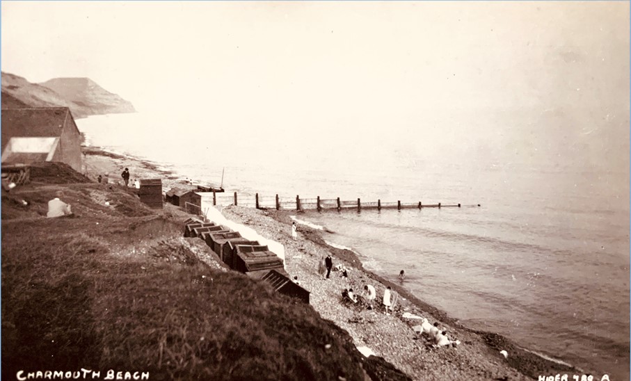
An unusual view Claud Hider took in 1923 from the path that led from the cliff to the beach below. In the distance you can see the roof of the old Cement Works which at that time was rented by the Hunters, who kept their tents and deckchairs there in the winter. The concrete promenade along the front and its steps to the beach had yet to be built. A few holidaymakers can be seen sitting on the pebbly beach.
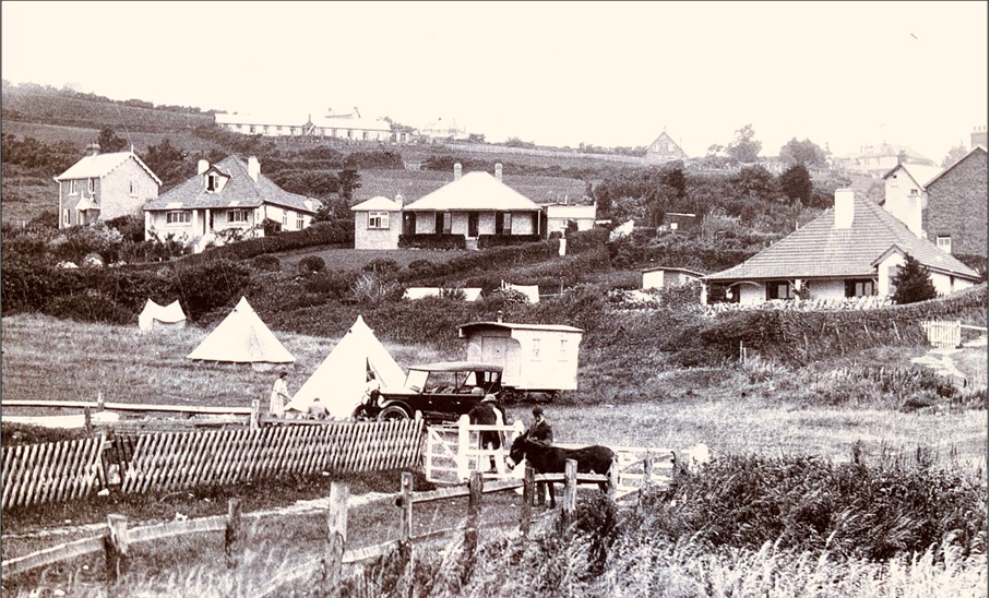
This postcard shows the field on which, in 1922 the house called Thalatta was to be built. On the horizon are several newly built-houses: Common Side, The Moorings, Cove Cottage, Sanctuary House and The Red Bungalow. Miss Helen Derrick was living in the latter at that time and it is her donkey, Patience that can be seen in the foreground. The Red Bungalow was built by Louis George and Mary Ann Derrick in 1909 and was lived in by Louis’ sister, Helen until her death in 1955. Her sister, Margaret joined her in 1938 after she sold her nursing home in Monte Carlo.
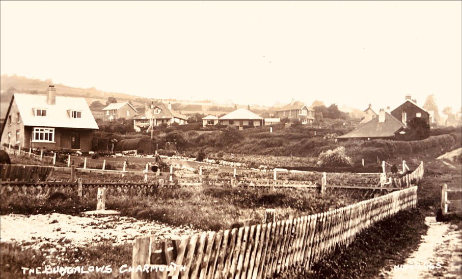
This unusual postcard shows just three of the five houses that were built on an acre plot called Single Common for Mr. Alfred Hodges, who was living at Claremont on The Street. Claud Hider must have published this card specially for him. The houses were built in 1928 by the local builder, William Cooper from Lyme Regis. The five houses in order from the junction of Higher Sea Lane are: Cuillin, The Croft, Sea Meadow, The Leas and Lias-Lea. In the distance is Stonebarrow Hill.
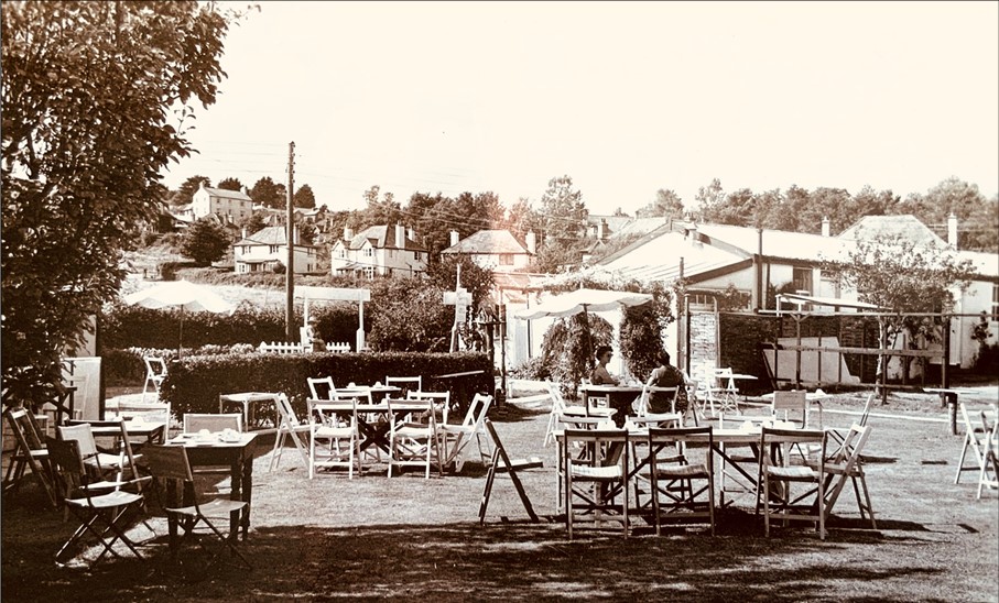
As well as publishing numbered views of the village to resell in his shop or other outlets such as the Post Office in Charmouth, Claud Hider would also take on special commissions. This was the case with this wonderful view looking down on to Higher Sea Lane with the impressive Sea Horse House Hotel in the background. The foreground shows the allotments and the garden of Claremont . It was one of a pack of 6 separate views relating to the Claremont Boarding House in 1931 which would have been given out to guests by the owner Elizabeth Littlebury.
This postcard published by Claud Hider in 1932 shows us the newly opened playing fields. It was in this year that
former resident Charles Hodges left the village £1000 to purchase the land from Douglas Pass. Charles lived to the age of 92 and his tomb is near the entrance to the church, which he presented with its brass lectern and £500 for the poor. In 1864 Sir John Hawkshaw planned a railway to link Bridport with Lyme Regis. The station was to be built on Charmouth Mead where the Recreation Field is today, with entry down Barrs Lane. It was never built as the
government at the time dismissed the idea and Hawkshaw put his estate up for auction soon after.
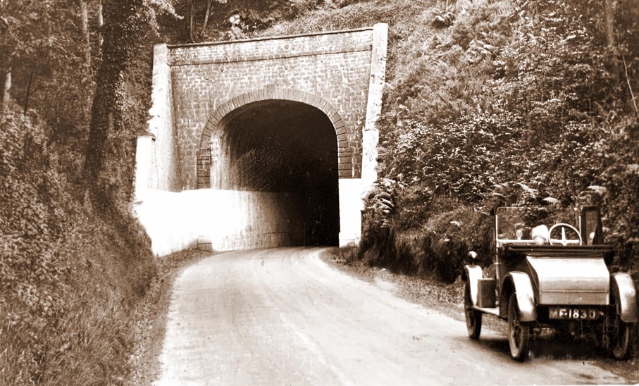
Claud quite often included his car in his photographs. One can just make out a child's face with a woolly bonnet on his head. On the left is the entrance to the former Charmouth Tunnel which was opened in January 1832, when two London to Exeter coaches passed one another in opposite directions amid much public rejoicing. The Tunnel was made so that coaches could avoid Fern Hill and it reduced the climb over Thistle Hill. It became redundant when the Charmouth bypass was built in 1990 and in 2004 it was transformed into the Target Sports Centre with its rifle range.
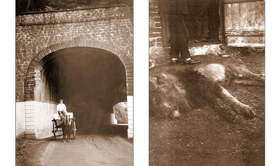
The photograph on the left shows a horse and cart passing through Charmouth Tunnel, which was 73 feet in length. The other postcard provides a unique record of the sad end of Pasha the Lion from Chapmans Zoo, who on the 22nd June 1929 escaped on the road near Fernhill, just outside Charmouth, after the tractor pulling his cage hit a tree. Crowds gathered to see the sight and the frightened animal bounded over a hedge at Lily Farm, saw some cows and siezed one by the throat. Fred Marsh, the local butcher shot the poor animal dead, and the photo taken by Claud Hider and published as a postcard shows him by a doorway at the farm.
This view taken by Claud Hider in 1929 is difficult to interpret today as the cottage in the middle must have been demolished for the present day bypass and the site is now under the roundabout at the top of Charmouth. The signs in front of the cottage advise drivers to fork left for Lyme Regis and right for Exeter. After a number of lorries and other vehicles crashed into houses and shops on the steep hill into the village, the Minister of Transport was finally convinced of the need for a bypass and it was constructed in the 1990s.
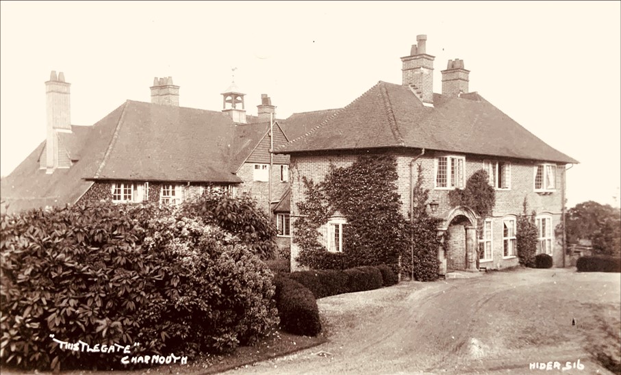
Albert Capper Pass was born in Bristol in 1837, where his father worked as a metal refiner and dealer. He later moved to Bedminster into much larger premises and prospered by processing gold and silver as well as lead and copper. In 1870 his father died, he took the business over and it went from strength to strength under his guidance. Towards the end of his life he bought the Manor of Wootton Fitzpaine and other estates which he left to his son, Douglas on his death in 1905. His wife instructed the architect, Francis Troup to design her a Dower House which she called Thistlegate, which she moved into after the marriage of her son in 1912.
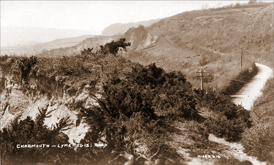
This photograph taken in 1922 shows the road that led into Charmouth through the Devil’s Bellows. In 1821 a scheme was proposed to cut a new road south of it across the upper part of the undercliff of Black Ven through to Lyme Regis which would not be as steep and hazardous as the existing one. The earlier route became known as Old Lyme Hill and the new one was named Old Lyme Road. Shortly afterwards in 1828 it sank 20 feet and even in 1912 the papers
referred to its terrible state.
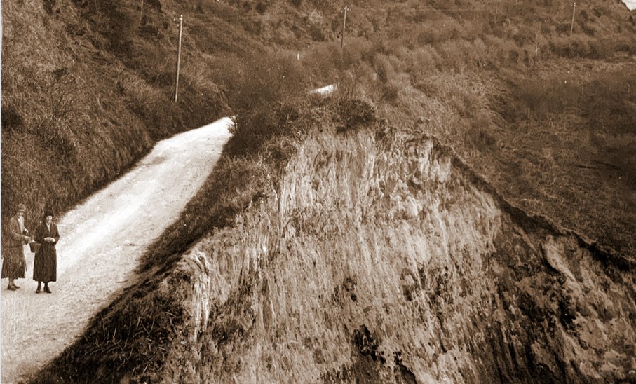
The cliff below Charmouth Cutting had been slipping for some years. The slippage was halted for a time by the surface of the road. When this gave way the fields above the Cutting gradually disappeared. Finally on 26th May 1924, the road was closed to all traffic after another landslip. This dramatic photographic postcard was published as part of a series by Claude Hider of Bridport shortly after the great landslip. It shows how close to the edge of the cliff the side of the road was. There was a sheer drop of 150 feet from the road to the beach below.