
Scenes from its Past - Part 1
Just click on Charmouth Beach - Scenes from its Past - Part 2 for the second part.
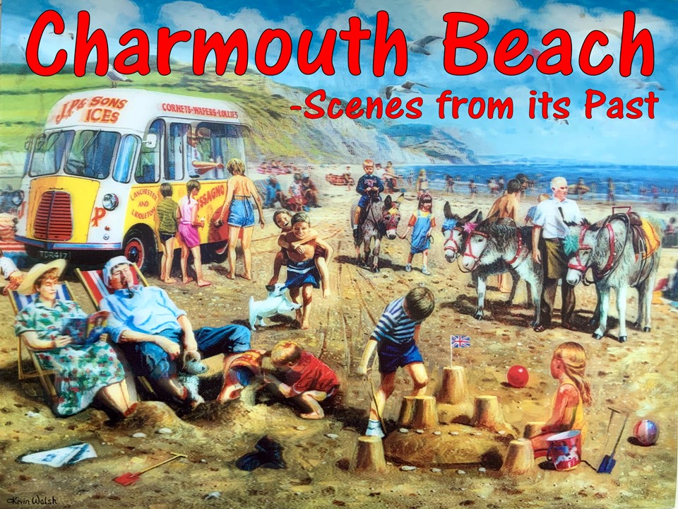
Charmouth owes its existence to its proximity to the sea and the river Char, from which it gets its name, although much altered from its original of Cerne mouth.The talk will cover its early history stretching back nearly two thousand years on the Roman Road in the first part and then as a popular resort in the second part. There will be a half hour break in the middle for refreshments.
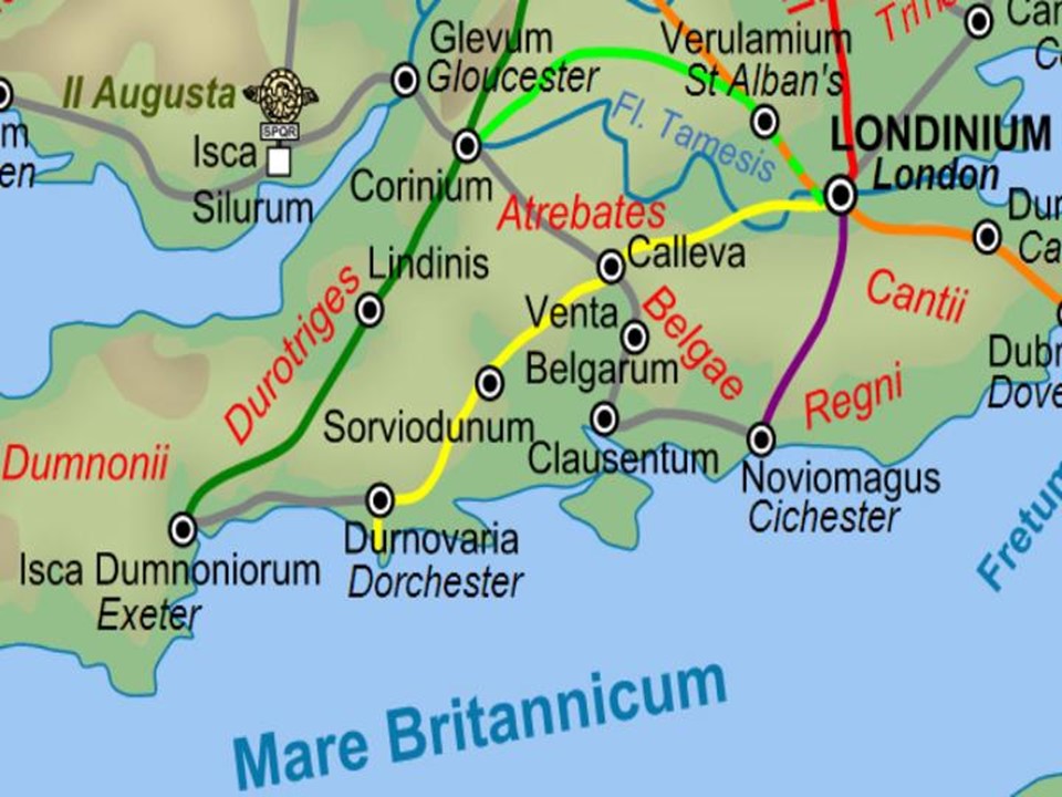
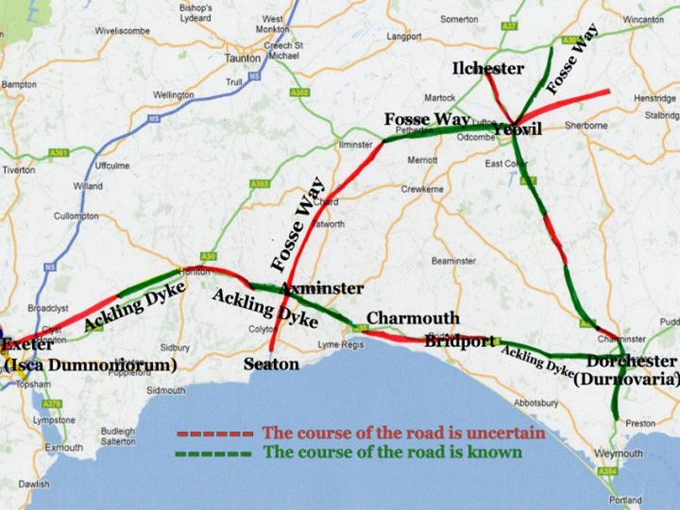
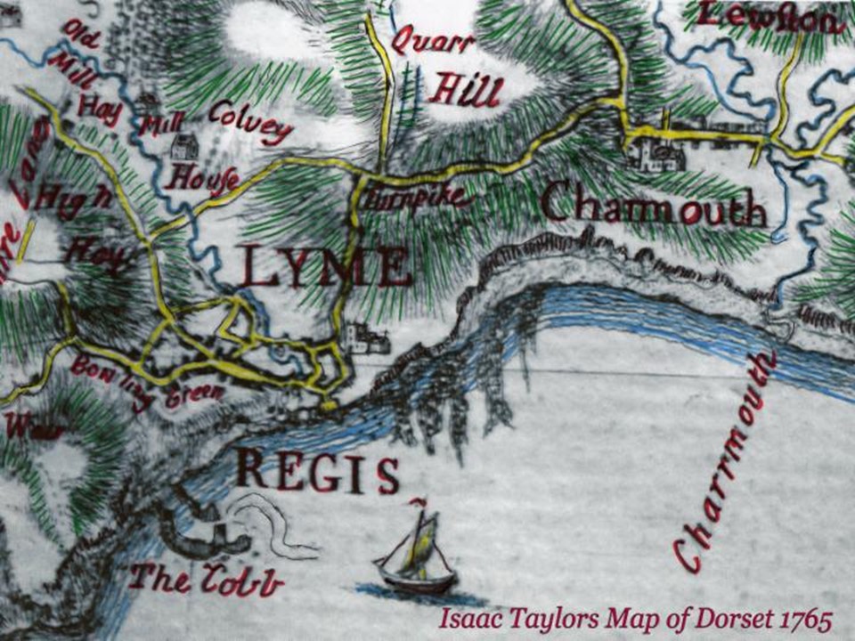
This present day map shows roughly the two main roman roads near to Charmouth. The Fosse Way marked a diagonal route from Lincoln to a port near Seaton and went though Axminster roughly paralleling the Cotswolds and then making use of the Axe valley. The Ackling Dyke is the name generally given for the road that linked Exeter and Salisbury, via Dorchester, which was probably built sometime during the period 55 – 60AD. Those coloured red are for uncertain stretches. The village of Charmouth stood on the Roman Ackling Dyke Road that linked Dorchester with Exeter. A section of this was found in 2006 to the north of Hogchester Farm by the famous archaeologist - Bill Putnam.
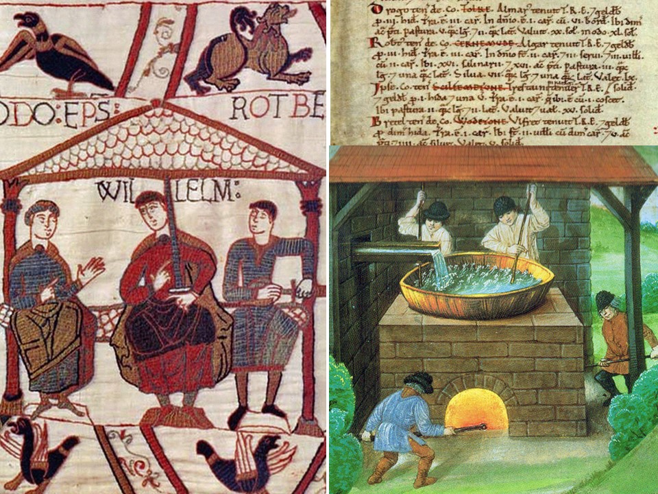
At the time of the Domesday in 1085, Charmouth was a small settlement producing Salt by boiling Sea water in large metal Basins and collecting the residue. Robert of Mortian in Normandy, the half brother of William the Conqueror, owned the village at the time of the Norman invasion. He is shown on the Bayeaux tapestry to the right of William. It was one of 71 Manors that he was given, which included Catherston and Wootton Fitzpaine. After his death in 1091,another French nobleman, William de Estre was shown as Lord of the Manor.
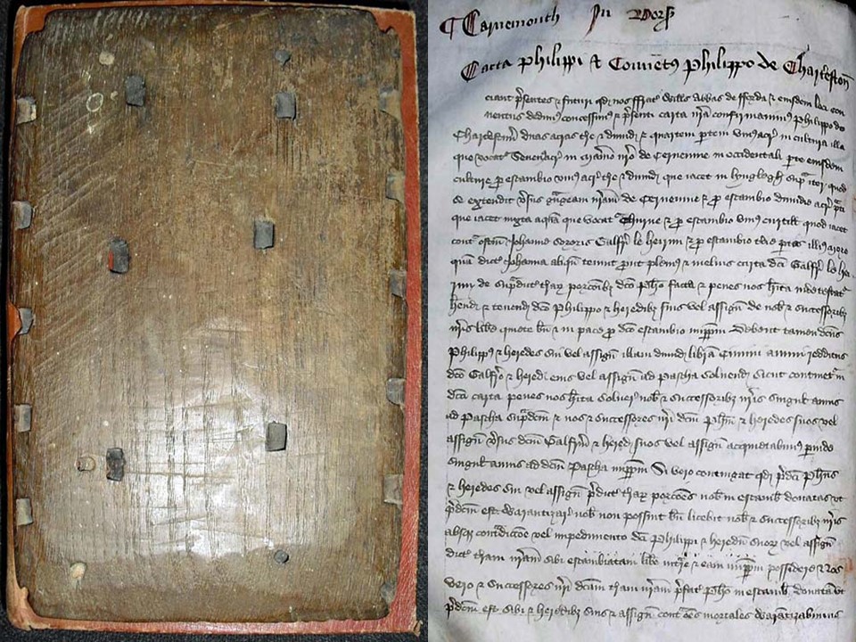
By 1170 most of the village lands had been gifted by Richard del Estre to Forde Abbey. We are fortunate that the owners of the Abbey today still possess an ancient Cartulary which records its early land transactions. The first 64 entries are for Charmouth and provide a wonderful insight to its history. It had a Grange, Guildhall, Mill, Market Cross, Pillory, Fair and Bridge. It was so successful that in 1290, William the Abbot improved the Manor by making it a free Borough. The entry is very descriptive of the boundaries and half acre burgage plots that were created along the Street.
By 1170 most of the village lands had been gifted by Richard del Estre to Forde Abbey. We are fortunate that the owners of the Abbey today still possess an ancient Cartulary which records its early land transactions. The first 64 entries are for Charmouth and provide a wonderful insight to its history. It had a Grange, Guildhall, Mill, Market Cross, Pillory, Fair and Bridge. It was so successful that in 1290, William the Abbot improved the Manor by making it a free Borough. The entry is very descriptive of the boundaries and half acre burgage plots that were created along the Street.
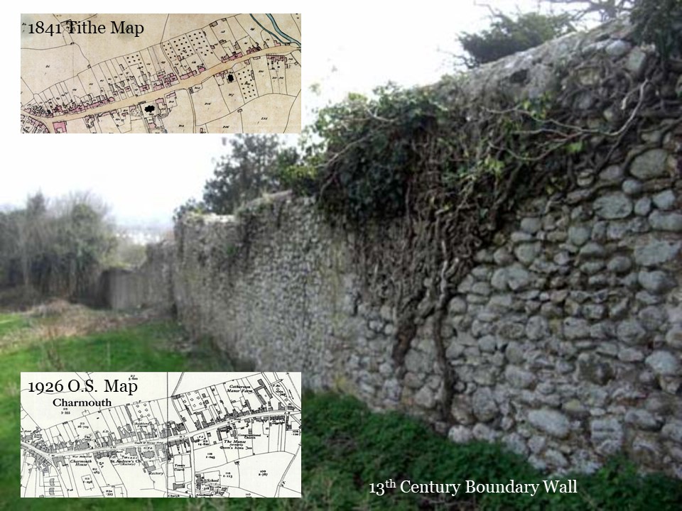
The virtually unbroken thirteenth century boundary wall is still there today parallel to the Street with many of the burgage plots stretching back to it. The 1841 and 1926 Maps show clearly the line of it.
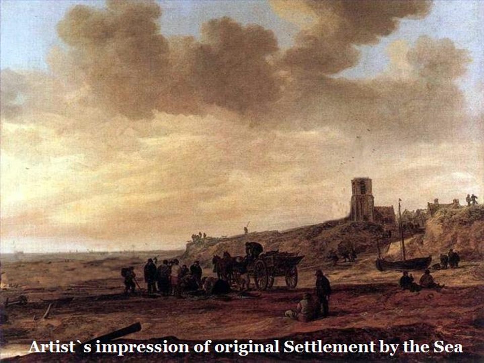
The Abbott had the foresight to create the new centre of the village a suitable distance from the ever-encroaching shore line. This was clearly seen in 1281 when Robert Wickhampton, Bishop of Salisbury wrote to the Abbott that “he had been informed by many trustworthy men that the Chapel of Charmouth, built a long time ago near the sea, has been ruined by the battering of the sea and storms”. He gave his authority and assent to the Abbott and monks if Forde, the patrons of the chapel, to move it to their new Borough, where its successor stands today. Further proof that the original settlement was sited in an area now far out to sea was in 1979 when a wooden bowl, carbon dated to the 12th century was found during low tide past the Heritage Centre, which is now kept in Dorchester Museum.
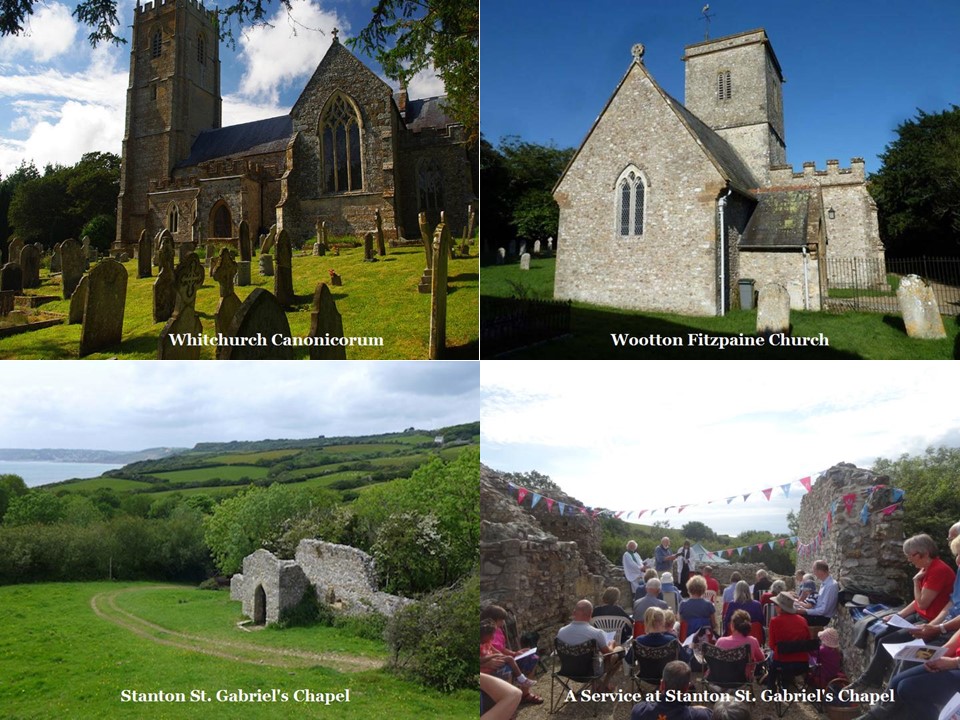
The earlier Building was one of several Chapels of Ease to the mother church at Whitchurch Canonicorum. It may well have resembled those still standing further along the coast at Stanton St. Gabriel’s and inland at Wootton Fitzpaine.
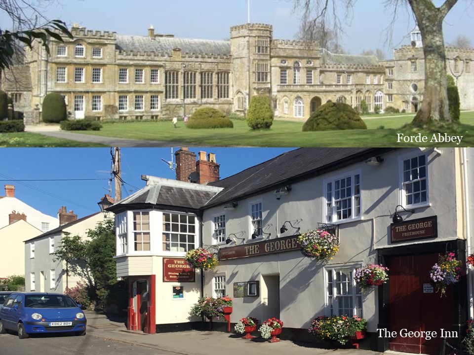
The Abbotts of Forde Abbey were to own the village for over 400 years until its dissolution in 1539. It established Inns for the accommodation of visitors there as it was an important stop off point along the road linking Dorchester and Exeter. The George Inn is the lone survivor of these today
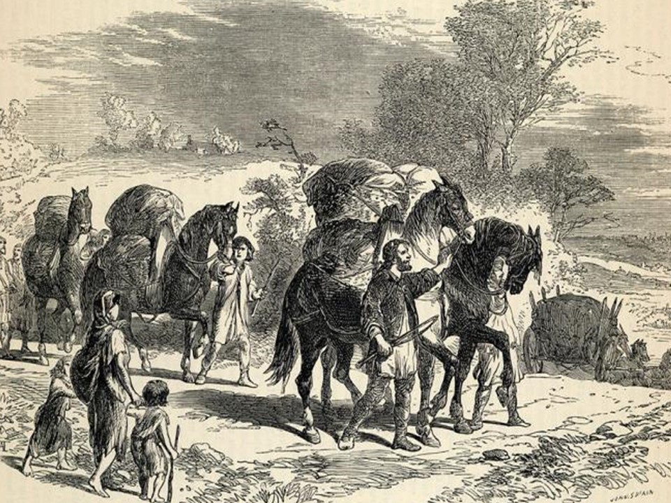
The road would have still been that which was created during the Roman Invasion and no doubt in an awful state after all that time and would have only been suitable for Pack Horses and heavy wagons.
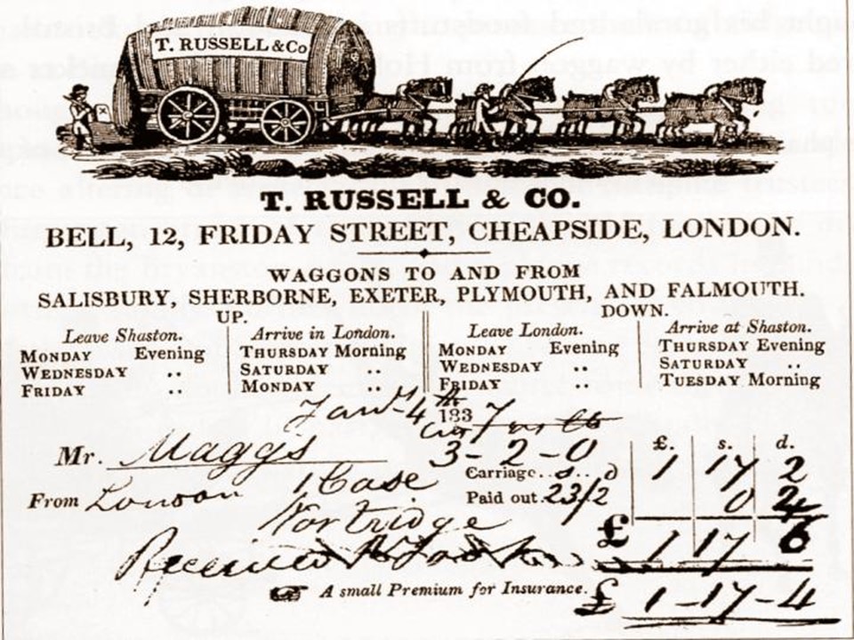
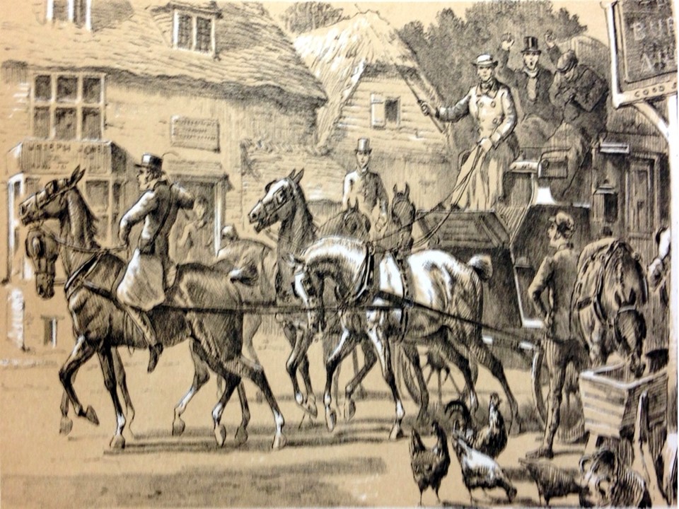
An important innovation in 1737 was the running of Waggons continuously, day and night with horses and waggoner changed regularly - this faster service became known as “Flying Waggons”. The road speeds of the service was no faster, but the time from Exeter to London was reduced by Russell’s from 7 days to 4 1/2 days.
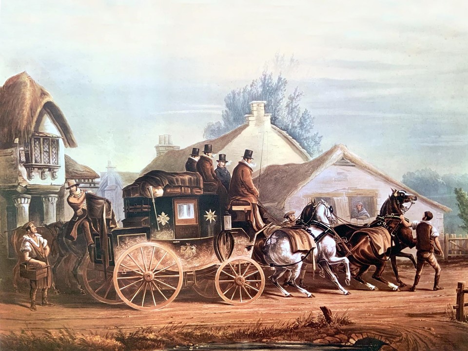
In 1739 the local newspaper recorded: “our townsmen beheld by only going to Charmouth, the wonder of the day, better known as the “Exeter Flying Stage Coach” which reached Dorchester from London in two days and reached Exeter in three days. The lofty Stonebarrow Hill had to be ascended from Morcombelake and the descent - a perilous one- to be made by the main road, better called narrow lane, beyond the eastern brook by Charmouth”.
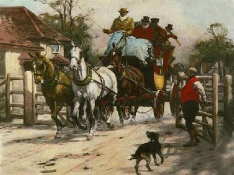
In 1757, there is a description of the existing road as that “ High Road leading from the Almshouse at west end of Charmouth to and thru Lyme Regis which are in a ruinous condition, narrow in many places and very steep and uneven and by reason of the waters in the winter season unpassable at divers places and very dangerous to travellers cannot be repaired, widened by present methods” As a result, the following year Charmouth had the first of its turnpike roads built. It was known as the Great Western Road and continued on as far as Aylesbeare, within a few miles of Exeter . It started from the top of the Street, where Claremont is today. There would have been a toll gate which were generally stout and substantial with a keeper as depicted here. A turnpike was a gate set across a new or improved road which was only opened when a toll had been paid to the turnpike-keeper.
This improved road was to transform the village with its fast links to London and a number of new houses were built soon after. Towards the end of the century, Charmouth with its neighbour, Lyme Regis was to be very fashionable and was written about in flattering terms. When properties were advertised for sale, the fact that it was on the Great Western Road and near to the beach were always referred to.
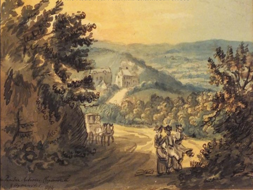
The watercolour shown here is dated 1794 of Penn Inn, just outside Charmouth gives us an idea of how the roads and countryside around Charmouth would have appeared at the end of the 18th century.
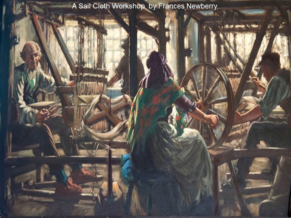
Although the village began to cater for visitors with its Inns and Lodging Houses, the majority of its citizens were employed in the fields mainly growing Flax. This was used in the manufacture of Sail Cloth in three factories established at that time, which were booming with their use on the ships being built for the long conflict with France. There was Burnards, by the Mill, Kitts in the centre at the corner of Barr`s Lane and Webber’s at the top of the village.
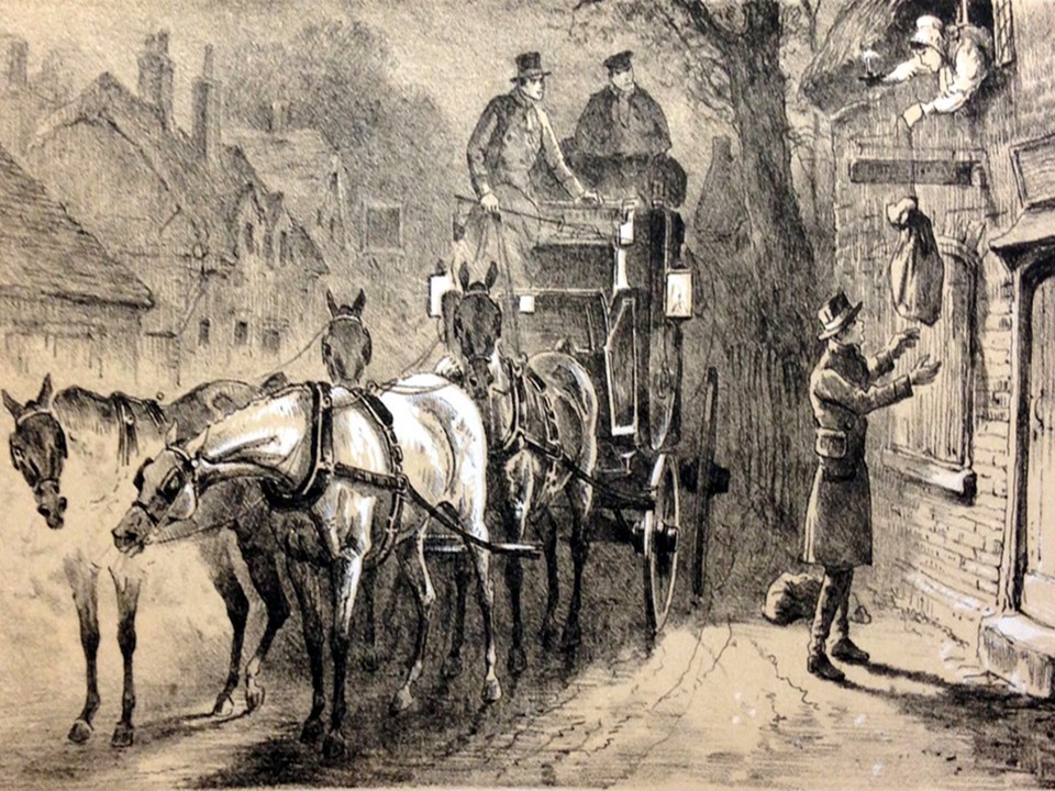
The main Inn was the Coach and Horses which stood next to the Church in the centre of the village. It had originally been called the Three Crowns. It later changed its name to the Mail Coach Inn, and then the Coach and Horses.
One of its tenants was Josiah Bradbeer who established a Post Office there, which he moved across the Street in 1807 and opened a Grocers shop there, which is still going strong today under the Nisa banner.
In 1783 most of the village lands came up for auction on 17th June of that year. It was “described as the valuable and improbable Manor of Charmouth, truly eligible situated in the midway Between Bridport and Axminster, on the Great Western Road and one and half miles from Lyme. A Place bequeathed with its healthy situation and convenience for Bathing”. It was bought by Lieutenant James Warden who was later to build Langmoor Manor at the edge of the village.
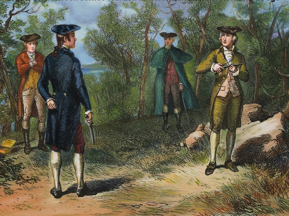
He was very argumentative and fell out with the villagers and the rector - Brian Combe for removing stone, sand and pebbles from his beach. He took them to court and won his case, although it must have been difficult to enforce. He was later to fall out with his neighbour, Norman Bond over his dog, which culminated in a Duel in 1792 in which he lost with his life.
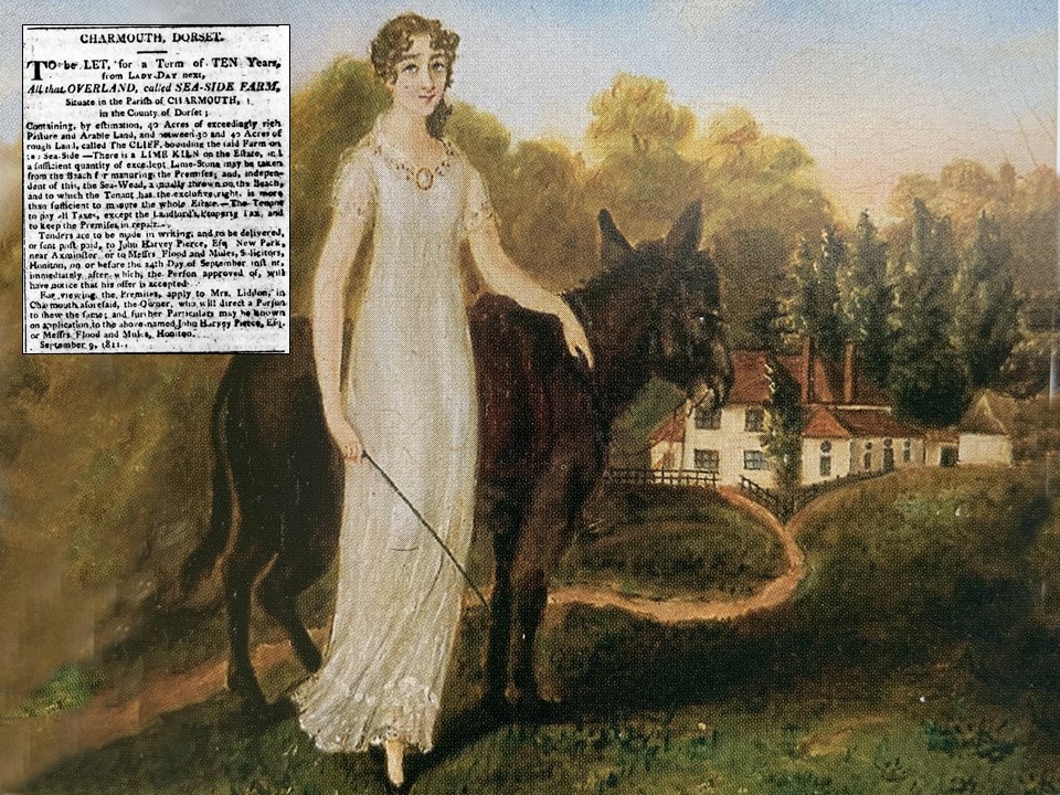
It was his daughter, Ann Liddon who was to inherit the estate. A Watercolour of Langmoor Manor and a young Ann are shown here with an advert in 1811 which provides an insight into the coast at that time which was owned by her.
To be Let, for a Term of Ten Years from Lady Day next.
All that Overland, called Sea - Side Farm, situate in the Parish of Charmouth, in the County of Dorset.
Containing by estimation, 40 Acres of exceedingly rich Pasture and Arable Land, and between 30 and 40 Acres of Rough Land, called the Cliff, bounding the said Farm on the Sea-Side - There is a Lime Kiln on the Estate, and a sufficient quantity of excellent Lime-Stone may be taken from the Beach for manuring the premises, and, independent of this, the Sea Weed, annually thrown on the Beach, and to which the tenant, has the exclusive right is more than sufficient to manure the whole Estate. - The Tenant to pay all the Taxes, except the Landlords Property Tax and to keep the Premises in repair.
Tenders are to be made in writing, and to be delivered, or sent post-paid, to John Harvey Pierce, Esq. New Park, Near Axminster, or to messrs. Flood and Mules, Solicitors, Honiton, on or before the 24th day of September inst. and immediately after which, the Person approved of, will have notice that his offer is accepted.
For viewing the Premises, Apply to Mrs. Liddon, in Charmouth aforesaid, the Owner, who will direct a Person to show the same, and further Particulars may be known on application to the above named John Harvey Pierce Esq. or Messrs. flood and Mule, Honiton. September 9, 1811.
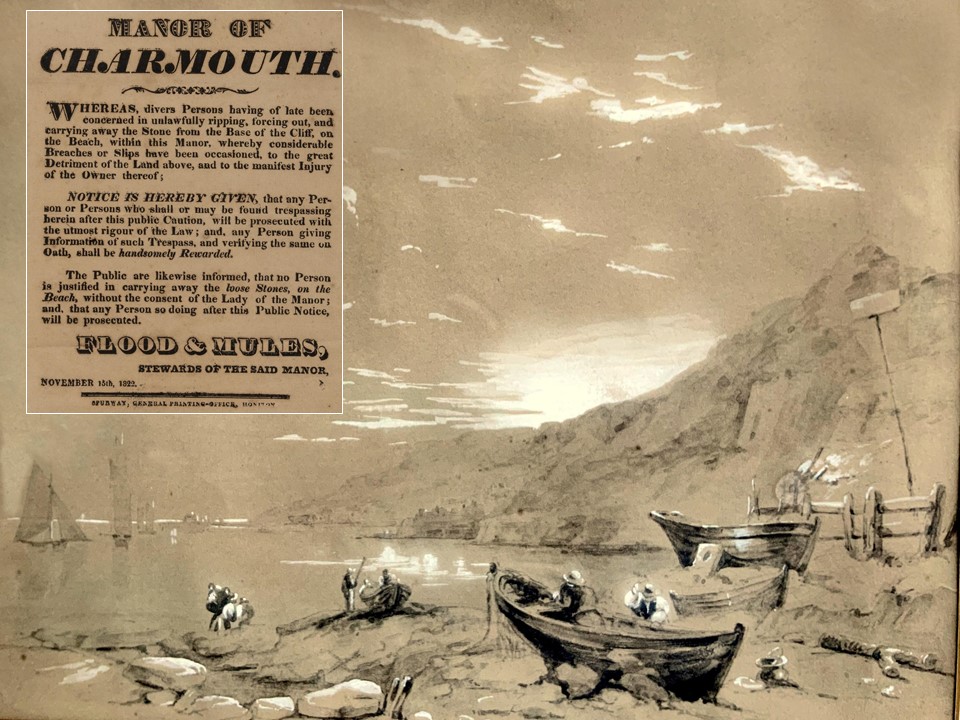
A watercolour by Carter Galpin of the Charmouth Beach looking towards Charmouth. The poster which would have been pinned to a board there makes interesting reading today inlight of the many rockfalls:
“Whereas divers Persons having been concerned in unlawfully ripping, forcing out and carrying away the Stone from the base of the Cliff, on the Beach, within this Manor, whereby considerable breaches or slips have been occasioned , to the great detriment of the land above, and the manifest injury of the owner thereof.
Notice is herby given that any person or persons who shall or may find trespassing Theron after this public caution, will be prosecuted with the utmost rigour of the law, and any person giving information of such trespass and verifying the same on Oath, shall be handsomely rewarded.
The public are likewise informed that no person is justified in carrying away the loose stones, on the beach, without consent of the Lady of the Manor, and that any person so doing after this public notice with be prosecuted.
Flood and Mules, stewards of the said manor, November 15th 1822”.
This must have been very difficult to enforce and there are a number of trials over the years by the Lords of the Manor to prosecute those who removed stones from the beach with little success.
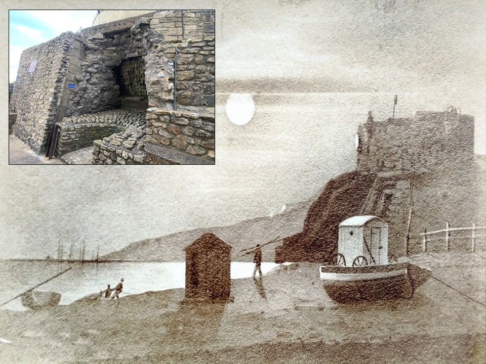
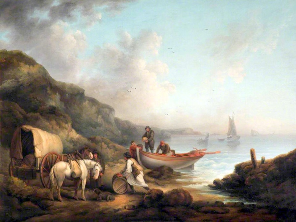
Many Dorset villages, hamlets, private estates and farms once had their own limekilns, to produce lime for building mortar and especially for agricultural improvements. Limestone and chalk were loaded, as fist-sized lumps, into the kiln pot, from the top of the bank. Alternate layers of stone and fuel (wood, gorse or coal) were loaded. Gaps between the stones allowed the even distribution of heat and the escape of carbon dioxide. As the burning proceeded the lime would crumble and collapse and be extracted through the draw-hole at the bottom. This would allow the further addition of limestone and fuel in an extended batch process which might last several days. The small hut in the middle of the picture is where a chap would have to wait whilst this happened. The Bathing Machine depicted in the painting is one of the earliest examples.
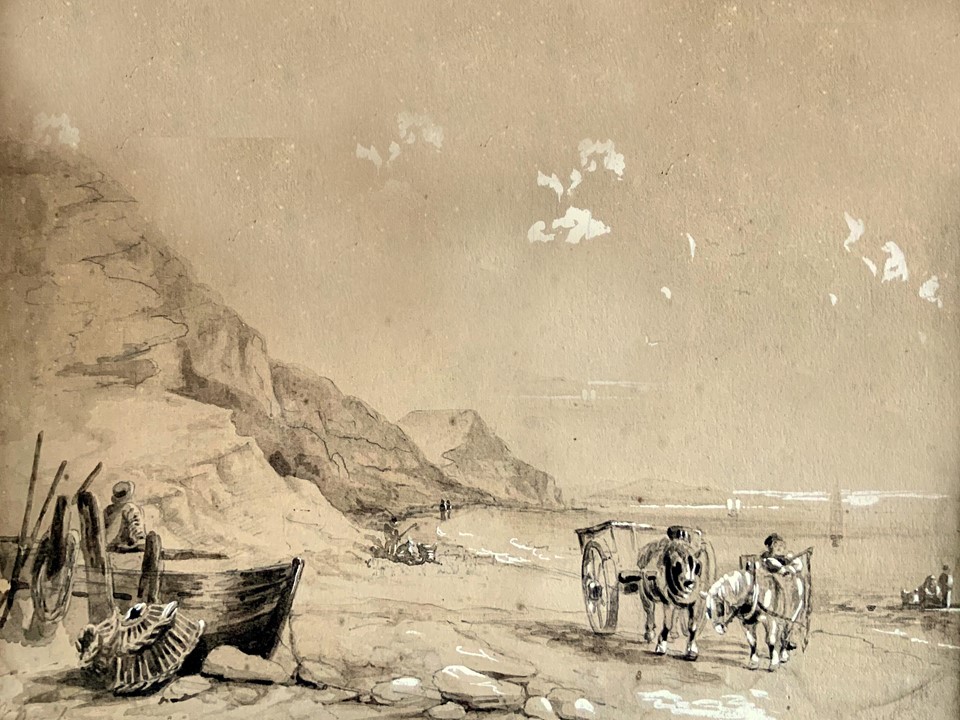
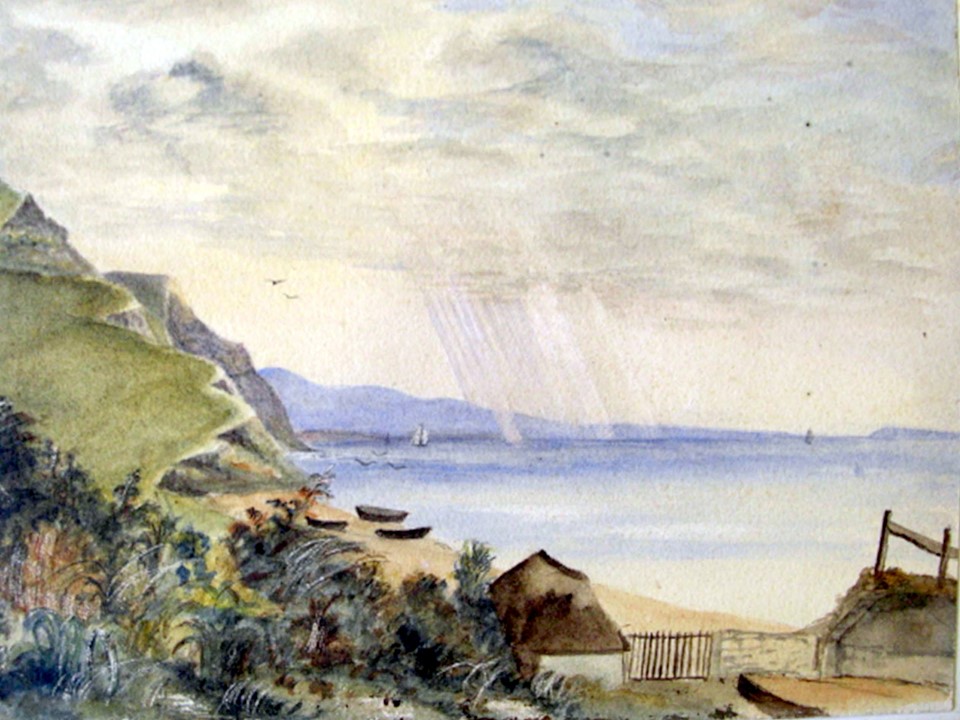
This is a another of the many watercolour by Carter Galpin with a view towards Golden Cap with Wagons collecting Sea weed and Stone. No doubt the same views today would be without much of the cliff which has been lost to erosion.
This Aquatint of Lyme Regis from Charmouth Beach by William Daniel is from his "Voyage round Great Britain“ published in 1814 . The Foot path shown on the right ran along the edge of the cliffs for the whole distance between Lyme and Charmouth .
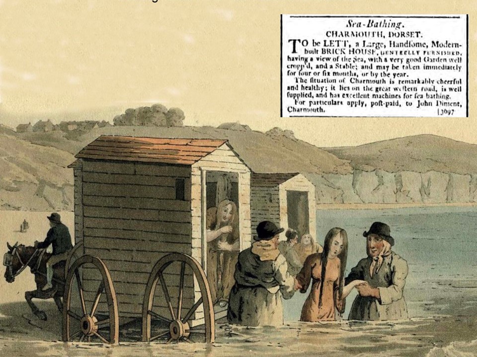
With its closeness to Lyme Regis it was also able to benefit from the boom in visitors taking the waters for their health and had its own bathing machines, which were very popular as a way of bathing in the sea without being seen. Wagons, called Bathing Machines, would be drawn out into the water by sturdy women, who might then assist the bathers down into the water where you could paddle about or swim in relative privacy, shielded from view of the shore. An advert in the Western Gazette from 1799 shown here records this advantage:
Sea Bathing, Charmouth, Dorset.
"To be let, a large, handsome, modern built brick house, genteelly furnished, having a view of the sea, with a very good garden well cropped and a stable, and may be taken immediately for four or six months, or by the year.
The situation of Charmouth is remarkably cheerful and healthy, it lies on the Great Western Road, is well supplied, and has excellent machines for sea bathing. For particulars apply post-paid to John Diment, Charmouth“
John was a Baker, living in a house where Devonedge stands today.
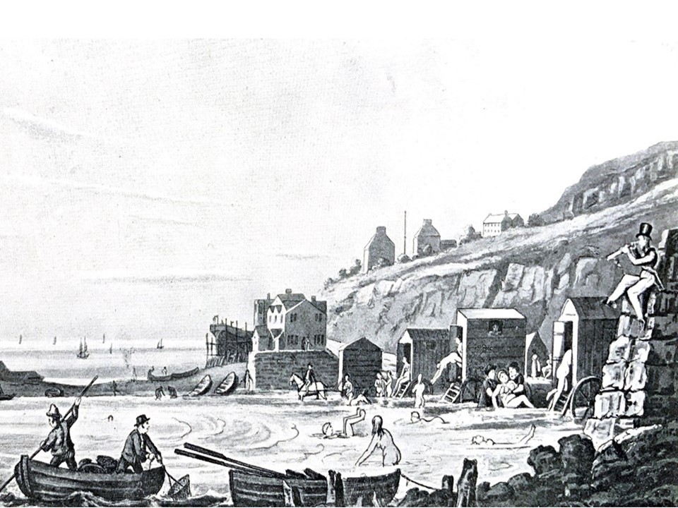
This engraving of Lyme Regis is based on a sketch by Captain Frederick Marryatt, who has a number of links with Charmouth in that his sister owned "Fernhill" and a daughter, Caroline married the local G.P. - Dr. George Norris and lived at The Elms. He was very famous as the author of "The Children of the New Forest“ and many other novels. It shows the sea front of the Assembly Rooms and the corner of Bell Cliff with a rather fanciful view of the bathing machines and the bathers.
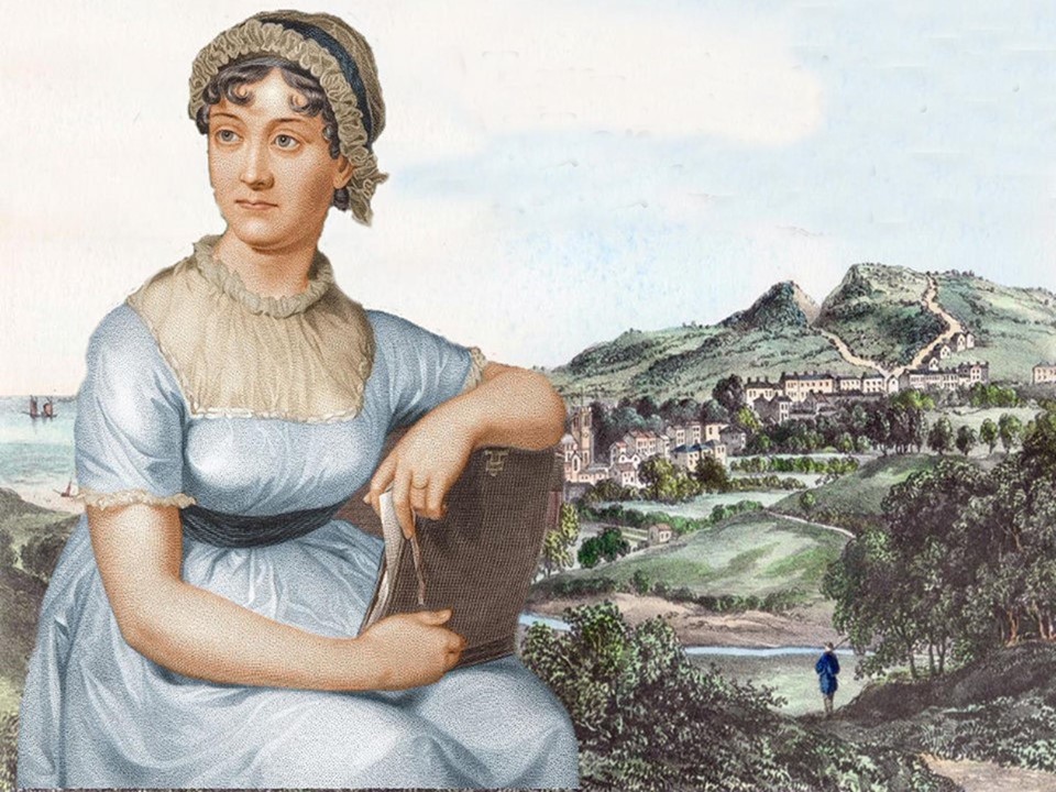
The famous author Jane Austen was to stay at the Coach and Horses in 1803. She was very impressed with what she saw and later in her novel, Persuasion described it as.. “Charmouth, with its high grounds and extensive sweeps of country, and still more its sweet, retired bay, backed by dark cliffs, where fragments of low rock among the sands make it the happiest spot for watching the flow of the tide, for sitting in unwearied contemplation”. Jane in Chapter 14 again refers to the this pleasure enjoyed by visitors as follows:
"Mary had been taken to Charmouth too, and she had bathed, and she had gone to church, and there were a great many more people to look at in the church at Lyme than at Uppercross; and all this, joined to the sense of being so very useful, had made really an agreeable fortnight”.
When she herself visited Lyme in 1804 she mentioned Charmouth in a letter to her sister, Cassandra.
"The bathing was so delightful this morning & Molly so pressing with me to enjoy myself that I believe I stayed in rather too long, as since the middle of the day I have felt unreasonably tired. I shall be more careful another time & shall not bathe to-morrow as I had before intended. Jenny & James are walking to Charmouth this afternoon".
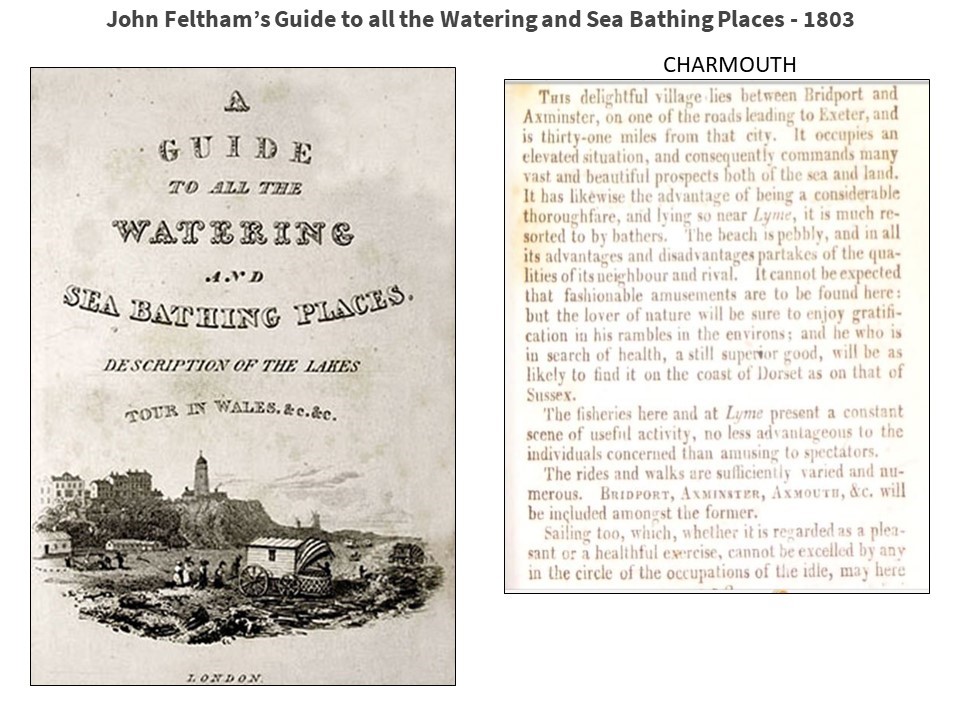
John Feltham published his first authoritative book on the subject with his “Guide to all the Watering and Sea Bathing Places” in 1803. It was produced annually until 1825 and would have been used by Jane and her family before visiting here. He floridly writes about Charmouth as follows:
“This delightful village lies between Bridport and Axminster, on one of the roads leading to Exeter, and is thirty-one miles from that city. It occupies an elevated situation and consequently commands many vast and beautiful prospects both of the sea and land. It has likewise the advantage of being a considerable thoroughfare, and lying so near Lyme, it is much resorted to by bathers. The beach here is pebbly and in all its advantages and disadvantages partakes of the qualities of its neighbour and rival. It cannot be expected that fashionable amusements are to be found here: but the lower nature will be sure to find gratification in his rambles of the environs, and he who is in search of health, a still superior good, will be as likely to find it on the coast of Dorset as in that of Sussex.
The fisheries here and at Lyme present a constant scene of useful activity, no less advantageous to the individuals concerned than amusing to spectators.
The rides and walks are sufficiently varied and numerous. Bridport, Axminster, Axmouth, etc. will be included amongst the former.
Sailing too, whether it is regarded as a pleasant or a healthful exercise, cannot be excelled by any in the circle of the occupations of the idle, may here be enjoyed to the full, with facilities that render it still more inviting".
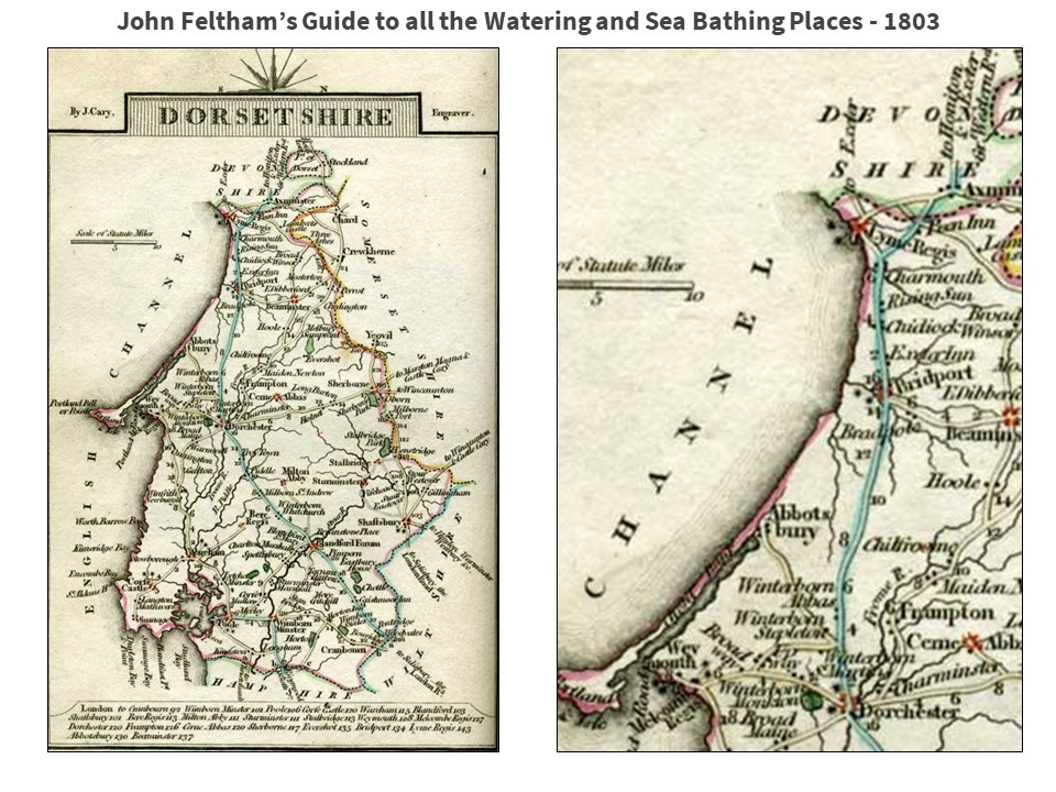
The map from the guidebook would have been the equivalent to google maps at the time providing the tourist with all the information he needed before his trip. It was a popular form of publication, listing over sixty places in England and Wales which had become fashionable either for their spas or sea bathing facilities (sometimes both). The route from London called at Andover, Salisbury, Woodyates Inn, Blandford, Dorchester, Bridport and finally Charmouth. To reach Exeter the coach would stop at Axminster and then Honiton before reaching that destination. The Tate Gallery has a copy of this guidebook that J.M.W. Turner ownws used when he travelled to Charmouth and the surrounding area in 1811.
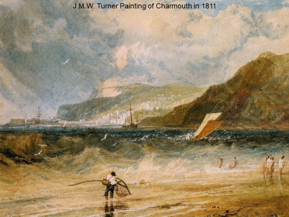
Britain's greatest artist - J.M.W. Turner visited Charmouth in 1811 and painted this beautiful view of a squall looking towards Lyme Regis, which now hangs in the Kelvingrove Gallery in Glasgow. There are 3 drawings in his "Devonshire Coast No. 1" sketchbook, at The Tate Gallery which records the village in that year. The Watercolour was later used for an engraving in the book “Picturesque Views of the Southern Coast of England”
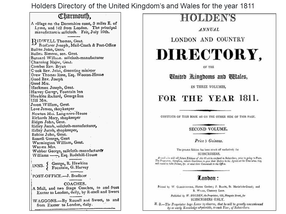
The earliest Directory for Charmouth dating back to 1811 by John Holden is surprisingly accurate and gives us an insight into both the inhabitants and their occupations. It describes the principal manufacturer as Sailcloth with the three main producers - Burnard, Ridley Kitt and Webber, highlighted. It was already attracting the well-off members of society who were described as Gentlemen. The most exiting entry is that for Charmouth entrepreneur - Joseph Bradbeer who was at that time operating both the newly opened Post Office, which is Nisa is today and the Mail Coach Inn, where Jane Austen would have stayed. The Directory entry highlights the fact that Russell and Sweet were operating Waggons and Stagecoaches daily from Charmouth.
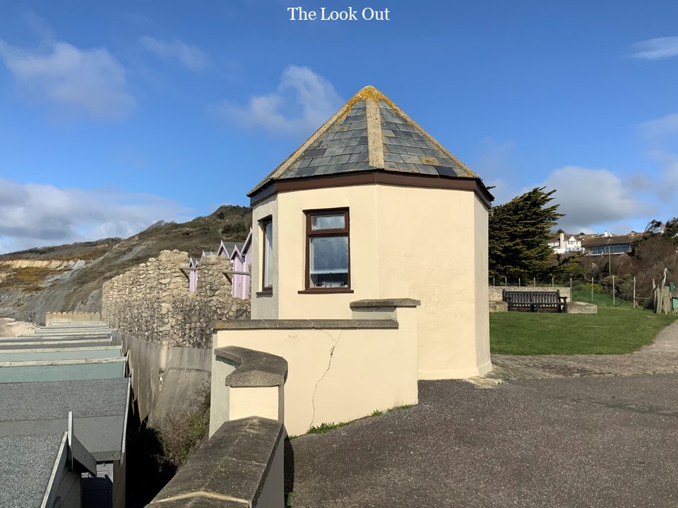
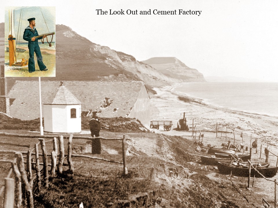
We still have a reminder of those early years with the Look out which was was built by the Customs & Excise Service in 1804, at a time when England took the threat of a Napoleonic invasion very seriously. The south-east coasts were the ones thought to be most at risk from a sally by the French from their great port at Boulogne, but in addition to the redoubling of vigilance at the Cinque Ports, preparations were made all the way along the south and south-west coasts. An observation and warning system of lookout and signal posts was established at prominent points along the shoreline, together with beacons on the highest hills inland, all designed to enable invasion warnings to be flashed across the country with great speed and- urgency. The invasion, however, never came.
Smuggling had for some time been rife along this coastline and, during the first half of the 19th century, the Lookout was used very effectively by the Excise & Coastguard Service in their endeavours to intercept the running of brandy from France, and to apprehend the smugglers. There is still a sunken lane running inland from the eastern cliffs of Charmouth which retains its earlier name of the Smugglers' Path.
“On the night of Saturday week, three men of the Lyme Preventive Station were on the look-out near the mouth of the Charmouth River, where they captured 150 kegs and two men. They had not retained possession long before they were attacked by a party of smugglers 70 or 80 in number and as is usual in such adventures, they appeared affected by liquor. They advanced with great violence. In defence, the officers were compelled to fire in the midst of them, in consequence of which, one man fell and was carried off by the party, who immediately retreated carrying with them all but 10 kegs and the two prisoners. One of the officers named Davis was mistaken for his brother, an extremely active man stationed near Bridport and nothing short of murder was intended towards him, as an attempt was made to cut his throat, which did not take effect, as the stock in his cravat prevented the weapon from making any serious incision. The smugglers continued to discharge large stones from the cliff upon the Revenue men who, though they were preserved by the darkness of the night from destruction, received some severe contusions, and are now confined in consequence.“
They left behind three of their number who subsequently served three months in Dorchester gaol. The registers of Dorchester gaol recorded similar imprisonments of Charmouth smugglers, including 21 year old Elizabeth Powell in 1824, and a 49 year old seaman, Henry Tippen, in 1828.
In 1824 there was another landmark in the evolution of the village when a new and improved section of Road was opened by the Bridport turnpike Trust. This new route around Golden Cap at a lower level allowed for an easier journey avoiding the steep hill. A house was built to collect the Tolls near the bridge at the bottom of the village, which still stands.
This early drawing of the village shows the new turnpike road travelling through the village past the toll house. A Cutting which can be seen in the distance which was made in constructing the Lyme - Charmouth road in 1824 was known as the Devils Bellows from the force with which the wind rushed through and was known to blow over a horse and trap.
Another steep hill was avoided when the Charmouth Tunnel was opened in 1832. It was so novel that over 1200 people were there at its opening and sumptuous dinners were provided at the Mail Coach and George Inns afterwards.
Charmouth’s new prosperity was reflected in the large number of fine houses and Villas that were built at the beginning of the 19th century. Many of these were let out for Lodgings in the summer season. To record these changes Charmouth had its very own artist - Carter Gilpin, who was living in the premises next to where Nisa is today. Some of his illustrations have survived and are shown in the following slides.
This picture of the Cobb was published in' 1825 by Carter Galpin. On the extreme right will be seen a vessel on the stocks in the shipbuilding yard, The figure in the foreground with her face to the sea and a geological hammer in her hand is probably intended to be Mary Anning.
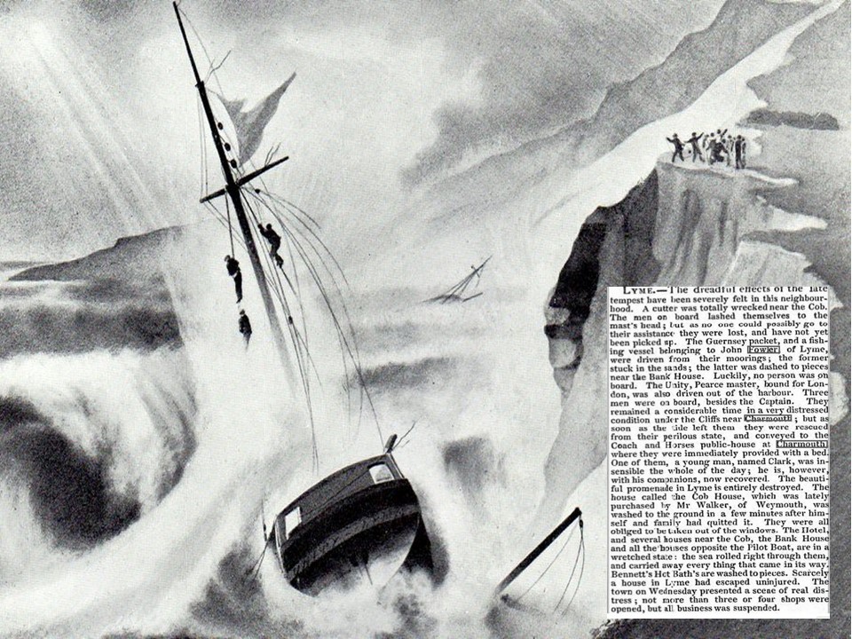
Carter Galpin depicted the wreck of the Unity off Charmouth in the ' new process of drawing in black lead' which he advertised, and for which he received the silver medal of the Society of Arts in 1826. The Unity was driven out of Lyme Cobb on the day of the great storm of 1824. The crew, lashed to the shrouds, were saved. Captain C, C. Bellett, R.N., of Lyme Regis, organized the rescue party and received from George IV. the Gold Medal of the National Institution for the Preservation of Life from Shipwreck. Out of this Institution the R.N.L.I. started in the following year. The Unity was refitted at the Lyme ship-yard and relaunched in 1825.
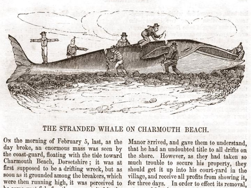
The Western Gazette of 6th February 1840 reported that:
“On the 5th February 1840 a large mass was observed by the coastguard floating towards the Charmouth Beach. They thought it was originally the hull of a wreck, but in grounding it was perceived to be a large fish. The preventive men got a rope round it and after an hour it died. It soon attracted a crowd of inhabitants. As there was a danger of it being carried off by the next tide, the Lord Paramount of the Manor, John Bullen, to whom as a drift from the sea it belonged, directed that it be cut into five parts. This was achieved by a large hand saw with great labour. After three days it was removed into the village and exhibited as a curiosity to visitors from all parts of the country for a week. The money raised, of between twenty and thirty pounds, was given to the preventive men and others who assisted. The extreme length was forty-four feet and the girth at the widest twenty-one feet. After being exhibited it was bought by a villager. He took the lean off for manure and the fat converted into oil. The bones were then buried in lime and cleaned. The owner then fixed the skeleton and placed it under a long shed for exhibition to the curious”.
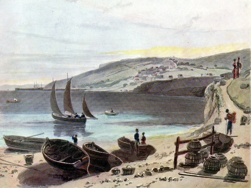
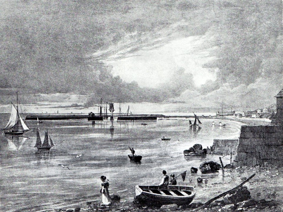
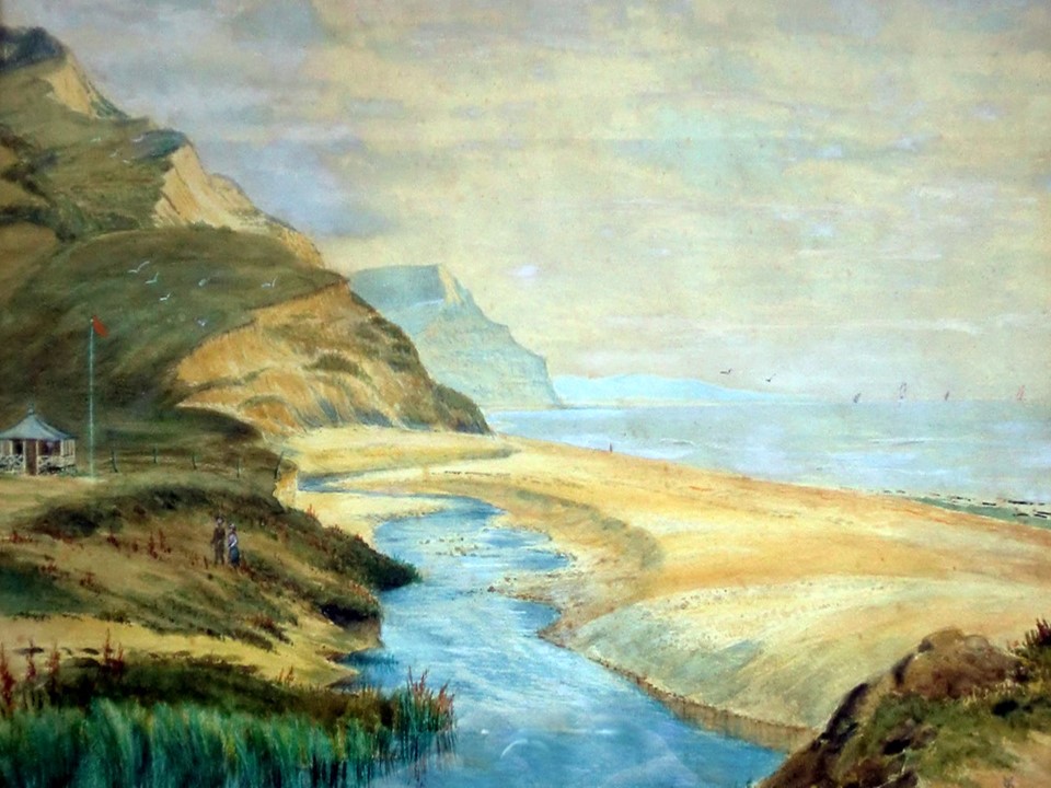
A view towards Golden Cap painted in 1850 by a local Amateur artist show the tranquil beach with its fishing boats moored on the sands.
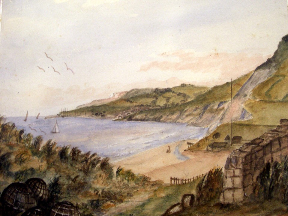
The companion painting this time towards Lyme Regis with the Preventative Station and Flagstaff.
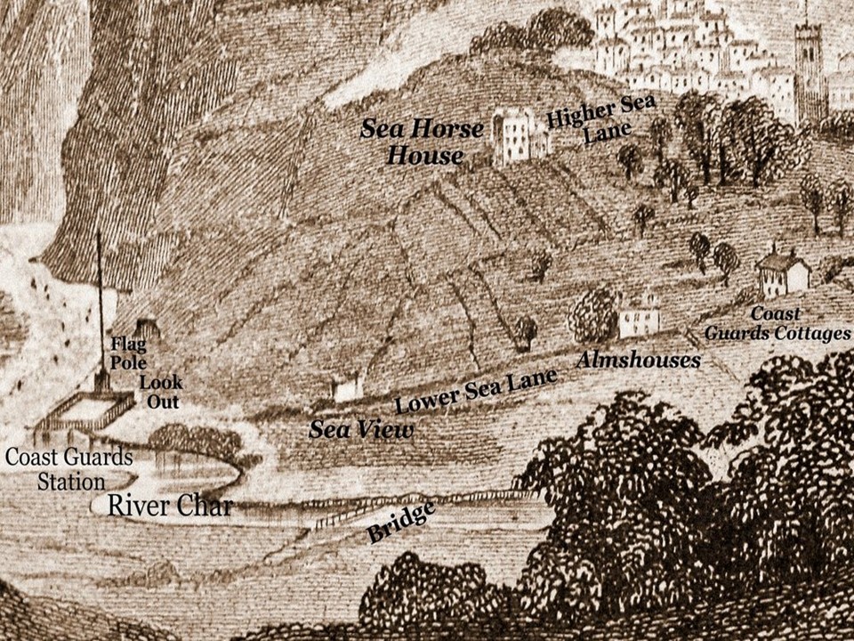
This engraving shows Charmouth in 1850. Although The Street had a large number of houses along its length, the area between it and the beach was sparsely populated. These have been marked on this slide. Higher Sea lane did not exist at this time apart from “Charmouth House” on the corner of The Street and “Sea Horse House”, built in 1803, near its entrance.
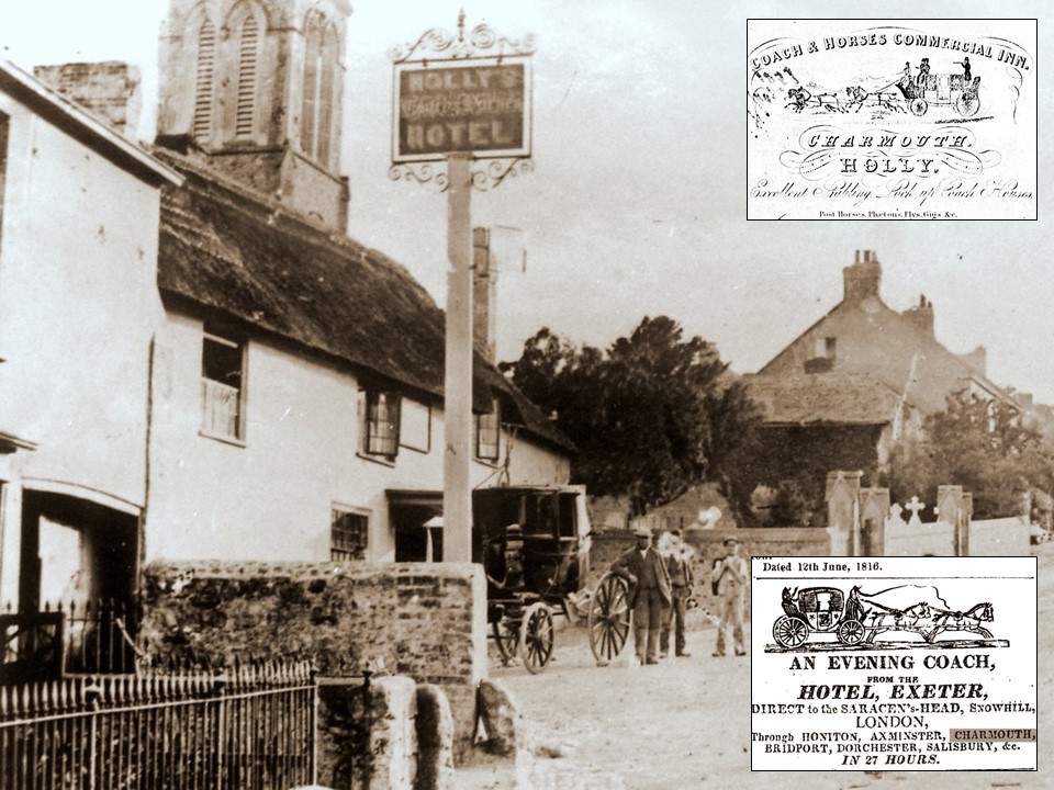
This early photograph shows the Coach and Horses in 1860 when it was owned by George Holly. During the Golden Age of Coaching so vividly depicted by Dickens in the Pickwick Papers our Village Inn could so well have been the model for that chosen by him. This period of history coincided with the introduction of the Royal Mail at the end of the 18th Century and was to quickly decline with the growth of the Railway. The Inn`s History is entwined with this and for a while was actually renamed "The Mail Coach Inn". There was a disastrous fire in 1895 which destroyed the earlier thatched building and was rebuilt in brick. It continued as a Hotel until 1996 after many centuries on the site and is now divided into apartments.
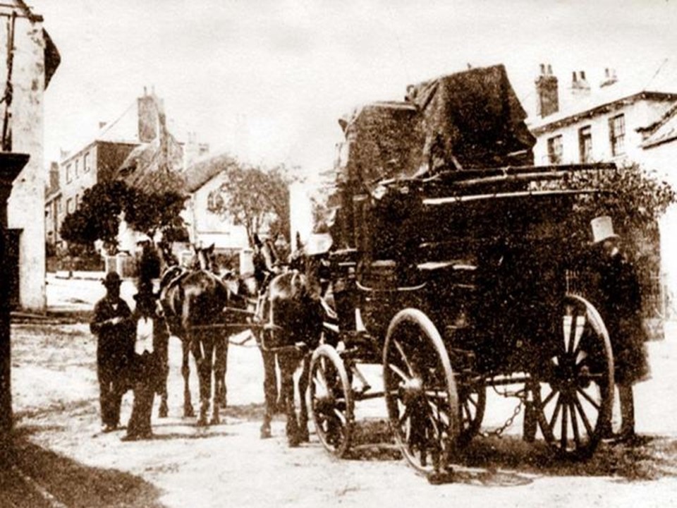
The photograph is very early and was taken by local School Master Mr. Bottomley. It depicts the last day of the Coronet Coach service in 1860 outside the Coach and Horses Inn. It ran between Bridport and Exeter from February 1858 till the summer of 1860 when the opening of the L.S.W Railway to Exeter brought the service to an abrupt end.
The London Evening Standard in October of 1853 reported the following: “Charmouth - That part of Charmouth cliffs and lands adjoining belonging to M. Liddon, Esq., lying between the Sea Lane and Lyme, has lately been purchased by a company of Plymouth gentlemen. The cliffs abound with large quantities of stone, which when burnt, produces an excellent cement of the Roman kind. We understand that kilns will be immediately built for its calcination."
The estate was bought by George Frean, aged 61, and his son George Henderson Frean, who originated from Plymouth, for £6500. The family had prospered, and George senior was shown as Mayor of the town at one time. They were described as corn merchants and operated a number of mills in the Plymouth neighbourhood. George had formed the Plymouth and Dartmoor Gunpowder Company near Postbridge, Dartmoor. The gunpowder was in great demand for both quarrying and for farmers clearing rock from their land.
Soon after purchasing The Charmouth Estate from Matthew Liddon, he sold Langmoor Manor to Ann Farwell Moly for £3400 and a parcel of fields to John Wilcocks for £2000. His name rarely appears in the records of Charmouth, for he continued to reside in Plymouth. It was his son, George Henderson Frean who was to later go on and found the famous biscuit firm – Peak Frean.
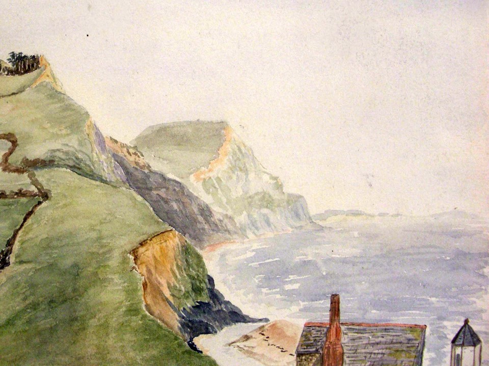
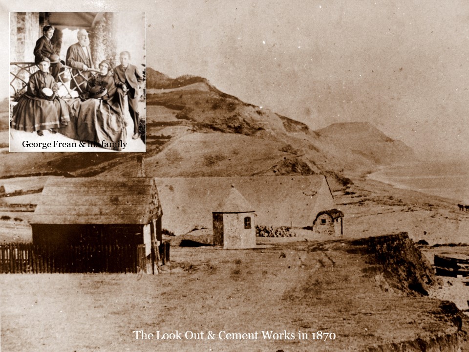
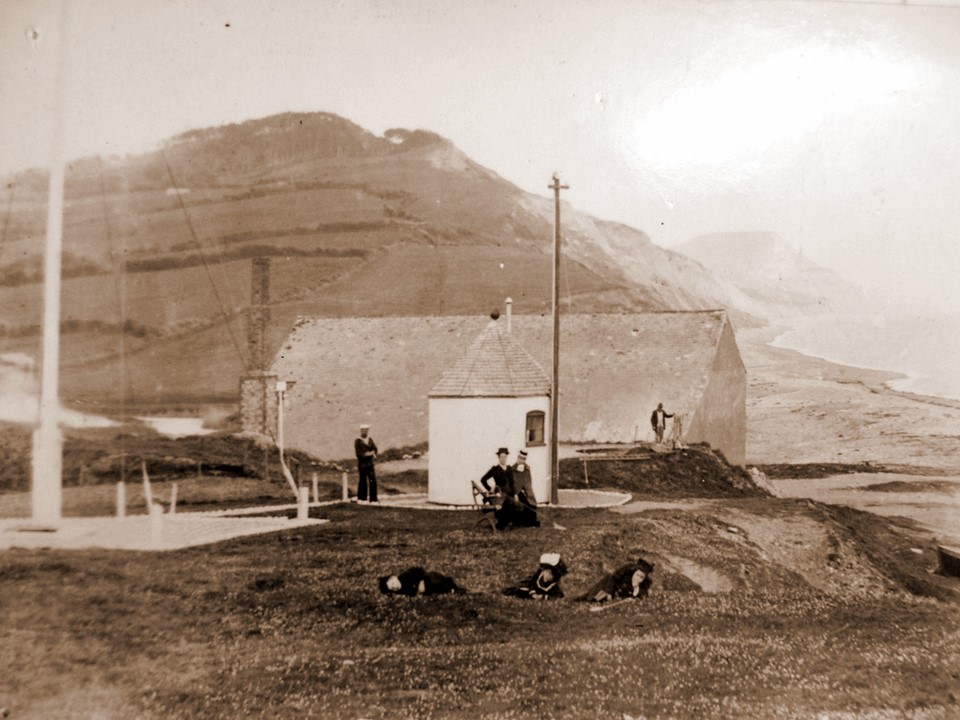
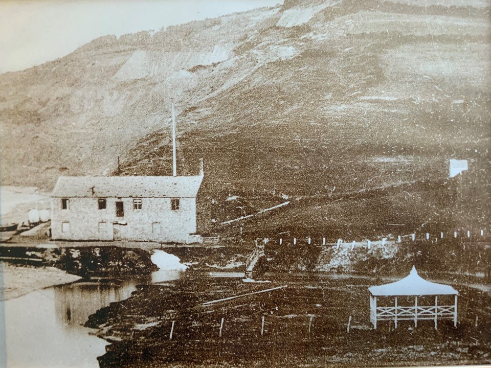
The entrepreneur, George Frean main focus was the setting up of a Cement Works near the existing Lime Kilns by the mouth of the River Char and the sea. His sister, Anna Frean had married Michael Morcom, described as a merchant at Plymouth in 1836. They were to have ten children. One of whom - George Frean Morcom was to later reside in Los Angles and become world famous as an Ornithologist. But in 1851, the family were living at St Agnes in Cornwall and Michael is described as a Mine Agent. No doubt with a background in quarrying the Morcoms would be ideal for running a Cement Factory for George. By January 7th , 1853 the building we see today had been finished by the local builders, Pryers and a later auction catalogue reveals that Mr. Morcom of Plymouth had a 21 year lease and was paying £100 a year rent for a Cement Mill, a Stone and Slated Building, with two floors, lean to, and two kilns. This early watercolour by a local amateur artist depicts the back of the cement works and the nearby Look Out in the corner of the picture.

The Factory was built for grinding the lime stones found on the beach for the manufacture of cement. It consisted of a large room facing east with double doors and a small office just inside on the left. Opposite the entrance was a doorway leading into the engine room and to the "boiler room. The engine was a small beam engine with a large fly wheel, by the side of which was another door leading to a room containing machinery, which is now used for storing deck chairs in winter, There were two other compartments, probably store rooms, one with a door by the side of that leading to the engine room and the other with an entrance from the yard outside on the west side* Opposite this door and built into the west cliff were two lime kilns. The boiler room had a tall chimney, which for many years was a very useful guide for fishermen for locating their fishing grounds. There were no doors or windows facing the sea,, The two store rooms are now part of the beach cafe. The upper floor was reached by outside stone steps in the N.W. corner - since demolished - and by an inside wooden ladder. The machinery was mounted on firm foundations probably used for grinding. "The stones were brought to the kilns by horse and cart and smaller stones, known as washers were collected by women.
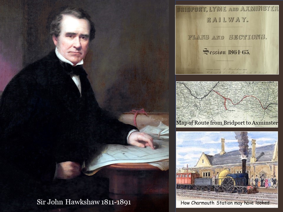
George Frean also operated a Cement Works in Lyme Regis, which proved much more successful which may well have contributed to his decision to sell his Estate to John Hawkshaw on January 1 1864 for £6000. This was precisely 10 years from the day he had bought his property in Charmouth from the Liddons and would have shown him a good profit.
John Hawkshaw's master plan in coming to Charmouth was to build a railway, become an M.P. and reside in a fine country house. He was to almost achieve all of these ambitions between 1864 and 1865. In buying up large Estates, houses and land in both Lyme Regis and Charmouth, he had a base to work from and was quick to win his voters over in a number of ways. As well as the promise of the prosperity that the railway would offer, he gave coal to the poor, treated his tenants well, built at his own expense a water supply and many other incentives for their votes. Bridport already had its Station, opened in 1857 and its neighbours were anxious to have theirs as well.
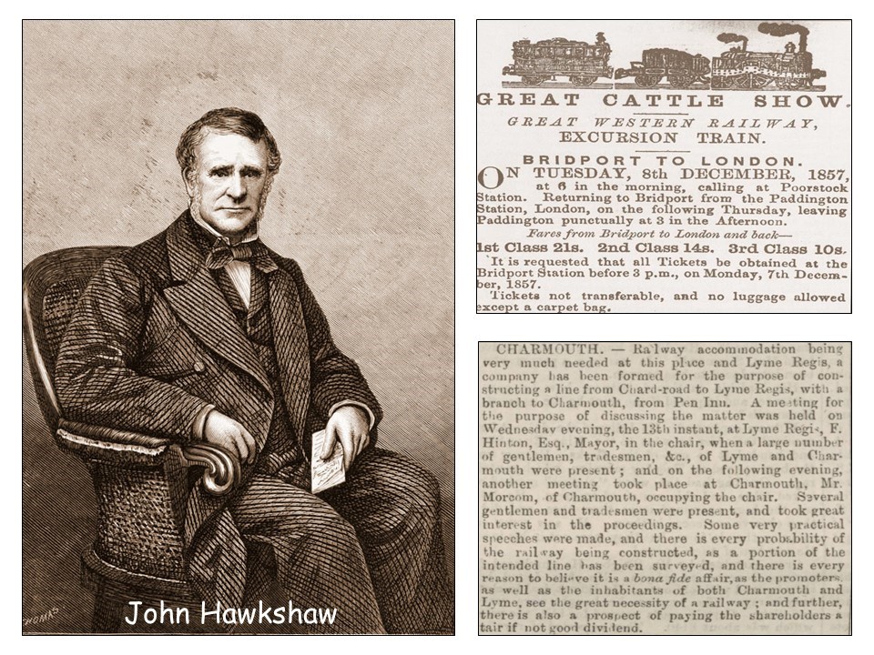
In July 1864, The local paper was to report Hawkshaw's activities as follows:
"Railway Accommodation being very much needed at Charmouth and Lyme Regis, a company has been formed for the purpose of constructing a line from Chard Road to Lyme Regis, with a branch to Charmouth, from Penn Inn. A meeting for the purpose of discussing the matter was held on Wednesday evening, the 13th instant, at Lyme Regis, F. Hinton, Esq, Mayor, in the chair, when a large number of gentlemen, tradesmen, &c., of Lyme and Charmouth were present, and on the following evening, another meeting took place at Charmouth. Mr Morcome, of Charmouth, occupying the chair. Several gentlemen and tradesmen were present, and took practical speeches were made, and there is a fair probability of the railway being constructed, as a portion of the intended line has been surveyed, and there is every reason to believe it is bona fide affair, as the promoters, as well as the inhabitants of both Charmouth and Lyme, see the great necessity of a railway, and further there is a prospect of paying the shareholders a fair if not good dividend“.
It is interesting to see that both Morcome and Hinton were both favorable to the project as they each rented their properties from Hawkshaw.
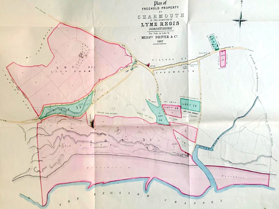
Sadly it was thrown out by the Government after lobbying from the Great Western Railway and in 1867 there was a massive auction of all his holdings in Lyme Regis and Charmouth including the foreshore and its lands. The Coastal lands shown on the map did not sell and were later bought by John Coulton. To give you an idea of how extensive Hawkshaw's purchases were in 1864, we show this map with most of Charmouth shown in pink and green that was his. Many of you here no doubt have houses that were on fields that once belonged to him. The large pink group of fields at the top is Lily Farm that he bought with a Blacksmiths and a number of cottages in the same year from Colonel William Pinney who had purchased them in 1850.
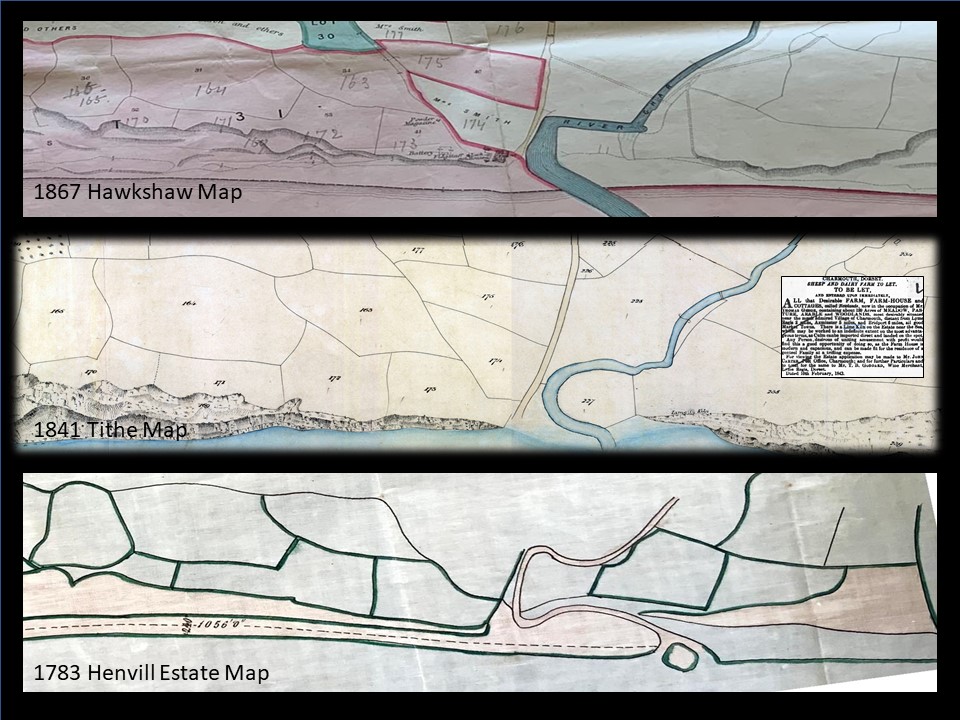
The 1867 map that went with the Auction Catalogue is interesting when placed alongside those of the lands fronting the beach as each clearly show the wide oxbow bend in the river alongside where the Heritage Centre is today. The 1783 map was originally part of a much larger estate map that has not come down to us, apart from the reference book that went with it. It is interesting to that there was once an island off the mouth of the river. When the Manor was sold in 1783 by the Henvills, the fields to the east of the river were bought by Rev. Brian Coombes. By 1841 they formed part of a farm based at Newlands and a Lime Kiln is shown on the map which was advertised two years later when it came up to be let. It was later bought by the wealthy Mrs. Stuart who lived at the Court and also owned Backlands Farm in the village.
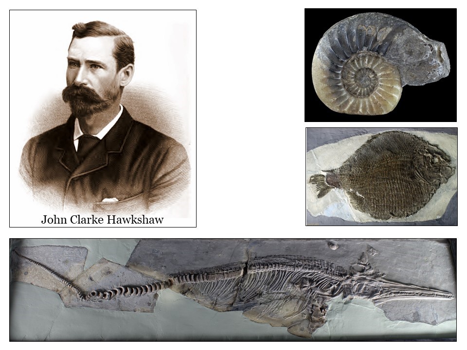
John Clarke Hawkshaw immediately after getting his degree at Cambridge joined his fathers practice in London and worked with him on many important projects. In the same year as he stood for election in Charmouth and Lyme Regis he married Cicely Wedgwood daughter of Francis Wedgwood, grandson of Josiah Wedgwood, founder of the famous pottery firm. Francis’s sister Emma Wedgwood married her cousin Charles Darwin. This family connection and the close proximity to the Jurassic Coast must have fostered his love of collecting fossils. His fine collection still exists and is on display in his original cabinet at Haslemere Museum in Surrey and contains a fine Ichthyosaur from Charmouth. The items were donated by his son Colonel Oliver Hawkshaw in 1922.Three of the items in the collection are shown here.
Edward Cecil Hartsinck Day attended the new Royal School of Mines in London and took up a geological career. To advance this he, in 1861, moved to live in Charmouth, one of the most 'geological' locations in England. His name appears on the Jury List for the village during his time here and is described as a Gentleman. The Charmouth Cricket Club was founded in 1863 and he was one of the founders and their Treasurer. He was elected Fellow of the Geological Society in the same year and published an important paper on the Middle and Upper Lias of the Dorset Coast. In this he identified a new shell bed in the Middle Lias which is now named Day's Shell Bed after him. The ammonite Dayiceras was also named after him by L.F. Spath following a suggestion from W.D. Lang, "to commemorate his important work on the Lias at Charmouth.“
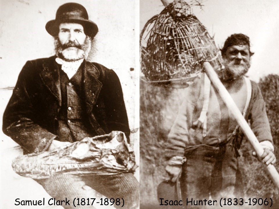
In 1864 Day purchased "one of the most perfect Plesiosauri ever found on the Dorsetshire coast" for £40 from the local dealer Samuel Clark of Charmouth shown here on the left. He was also assisted by a young Isaac Hunter, on the right in locating suitable examples for his collection.
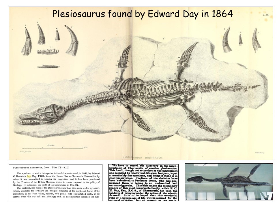
The illustration shown above is from Owen`s “A monograph of the fossil Reptilia of the Liassic formations” published in 1863. The most remarkable feature of this discovery was that in 1864 Day sold it on to the British Museum for £200, a fortune at the time. The Plesiosaurus can still be seen in a showcase on the wall of the Natural History Museum in London and is illustrated here.
Day was highly active as a geologist while he was at Charmouth. He helped Huxley with his researches on belemnites. In 1865 he revealed the true situation of the cephalic spines in the fossil shark Hybodus anningae and in 1867 he acquired from Isaac Hunter of Charmouth, a second new species of Plesiosaurus, which Richard Owen was to have called Plesiosaurus laticeps.
Day left Charmouth for America in 1867and was Assay Master in the Columbia College School of Mining. He then became in 1872, Professor of Natural Sciences at the Normal College, New York, where he was also active as a botanist. He died on 4 January 1895 in Algiers, whilst on tour in an attempt to recover his health.
The Morning Post reported on 23rd November 1824 that:
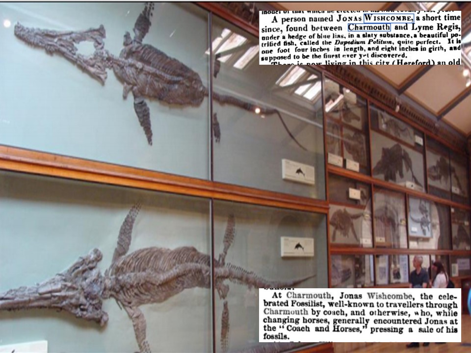
"A person named Jonas Wishcombe, a short time since, found between Charmouth and Lyme Regis, under a ledge of blue lias, in a slaty substance, a beautiful petrified fish."
Jonas Wishcombe, discovered many important fossils at the being of the 19th century.He rented Waterloo House, which is coincidentally a Fossil Shop today. He is listed as a Fossilist in the 1830 Pigot’s Directory, and worked with many of the famous collectors of his day. In 1832 he assisted Thomas Hawkins dig out one of largest Ichthyosaurus, which was sold for £210 to the Natural History Museum, where it can still be seen. In 1833 Hawkins obtained another Ichthyosaurus between Lyme and Charmouth. A claim had already been staked on this skeleton by Wishcombe, which was bought out by Hawkins. At low tide one day Hawkins with volunteers helpers including the Minister Benjamin Jeanes, managed to extract the specimen complete. The display in the Natural History Museum today of Ichthyosaurus, has a number that were found in Charmouth
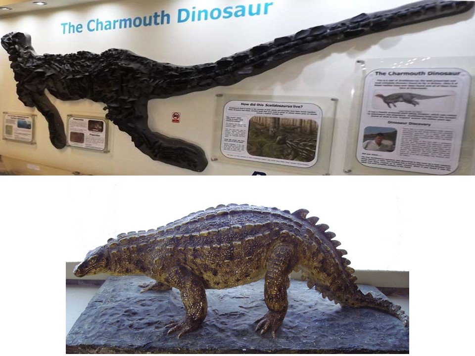
During the 1850s, James Harrison found fossils from the cliffs of Black Ven between Charmouth and Lyme Regis, that were quarried for raw material for the manufacture of cement in the Cement Works owned by George Frean and operated by his son in law, Michael Morcome. Some of these he gave to the collector and retired general surgeon Henry Norris who lived at The Elms. In September 1855 James Harrison moved to 3 Hillside in Charmouth where he lived until his death in 1864.
He is best known today as the discoverer of the earliest British dinosaur, which was named after him by Sir Richard Owen, Scelidosaurus harrisoni”. This was a plant-eating armoured dinosaur that was alive in the Lower Jurassic, around 195 million years ago. It has only been found here at Charmouth and nowhere else in the world. Since then around 8 partial dinosaurs have been discovered, a mix of both adults and juveniles. The most complete specimen was found by a local fossil collector David Sole in 2000.
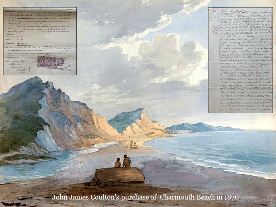
The 1867 Auction of the properties that John Hawkshaw had bought in anticipation of the Railway proceeding ahead between Lyme Regis and Bridport via Charmouth left a number of unsold Lots. These included the Cement factory and 64 acres of the surrounding fields and foreshore. These were eventually to be sold to John James Coulton, a Kings Lynn Solicitor. A copy of his receipt for the £3140 he paid in 1870 is shown here. He was to see little return on his purchase apart from the title Lord of the Manor of Charmouth. In the same year as the sale he gave a 7 year lease to local fisherman, Robert Hunter at a yearly rent of just 6d. for a license to operate 2 Bathing Machines on the beach. The original indenture is shown on the right. This was to be the start of the rise of the Hunter family who were to be involved with many activities on the beach.
John James Coulton was to be Lord of the Manor of Charmouth for almost 40 years and yet there are few records concerning him or reasons for him owning the Estate. The Parish records for 1896 show him bringing an action for taking stones from his beach.
In 1856, the Excise & Coastguard Services were formally taken over by the Admiralty, who continued to rent the Lookout and its adjacent flagstaff from the lord of the manor for £3 a year.
They had a shed that housed their gun which was run out to the edge of the cliff and the target placed on a reef of rocks. The shot was collected at low tide and used again. The fishing boats are drawn up on a raised platform made from the falling cliff. The boat in the foreground is a Larret or Herring boat. Both bow and stern are pointed so the boat could go out or come in without turning. A heavy Traction Engine and waggon can be seen by the Cement Works being used to haul stone from the beach.
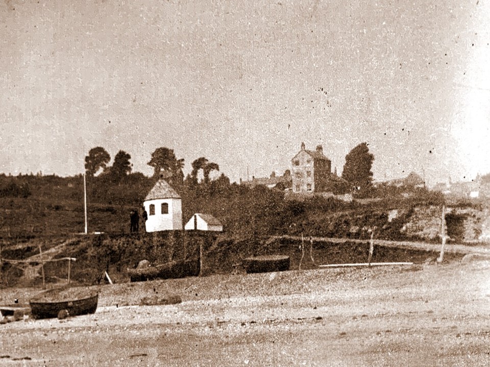
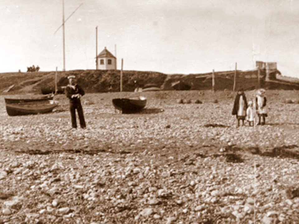
In 1909, the use of the Lookout as an observation post was discontinued, and in 1945 the building was given to Charmouth Parish Council. In 1989, it was designated as a Grade II listed building by the Department of the Environment. The National Coastwatch Institution now operates it as a Lookout after two centuries in this role.
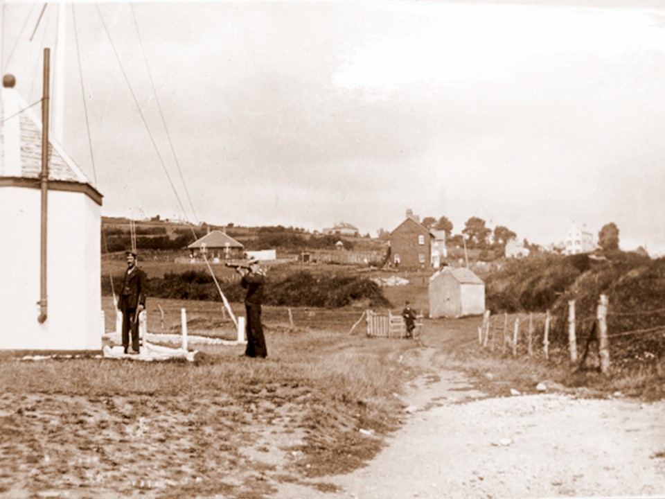
Another view from 1905 of the Look Out with two of the Coastguards on duty. Further down is an old chap leaning against the gate that led into their enclosure. Behind him is the Battery, where their ammunition was kept. The remains of it are near the entrance to Thalatta, which was later built near by. The Red Bungalow, Cove Cottage, The Sanctuary and Sea Horse House can be seen in the distance.
A similar view of the Look Out with some visitors in the foreground enjoying the Grass. The Old Cement Works in the background looks rather dilapidated with large holes in its roof.
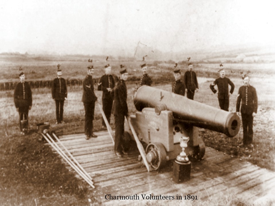
The Volunteers appeared for the first time on the Army List in 1866. They manoeuvred on the sward, which lay between the limbs of the meander at the rivers mouth. There they emplaced their artillery, and set up a target for rifle practice on the cliff by the Vineyard. At first they had horse drawn lumber guns with big spoke-wheels. New guns, two 24. pounders and one 64 pounder, replaced the old, and were mounted on platforms made of railway sleepers; and a magazine house was built alongside.
Charmouth won the County Challenge Cup for gunnery in 1891, a photograph of which is shown here, although it was later disbanded in 1895.
When the Volunteers ceased in 1895, their Band was retained as the Village Band.
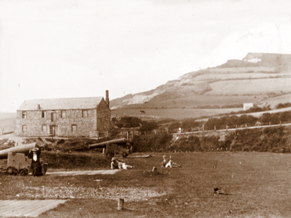
Another photograph of the Cannons on the foreshore with the Cement Factory in the background. It was rumoured that they were later buried under the Car Park.
In 1898 John James Coulton who was the Lord of the Manor tried to auction part of his Estate in Higher Sea Lane off as a planned building site for 55 houses. Unfortunately for him only a few lots were sold. Undeterred he tried again in 1904, but this time no one turned up for the Auction . Some of the plots were sold on afterwards and Higher Sea Lane slowly was built on over the century. In 1902 he sold a piece of land to Bessie Lessiter and on this she was to build the unusual “Red Bungalow” at the bottom of Higher Sea Lane. The photograph of him is when he was 86 and visited the village at the time of the second auction. He had just walked from Lyme Regis and picked up a bunch of seaweed on the way.
This early photograph taken in 1890 of Charmouth Beach reveals the Look out at a much lower level than today. The Lerretts for catching Mackerel are in the foreground. On the right can be seen the remains of one of the two Lime Kilns. The Look Out and the shed where its Cannon were kept are behind them. In the background towering above the fields is Sea Horse House, for a long time the only building on Higher Sea Lane.
A similar view to the last with a Customs Officer in front of the Look Out where he operated from.
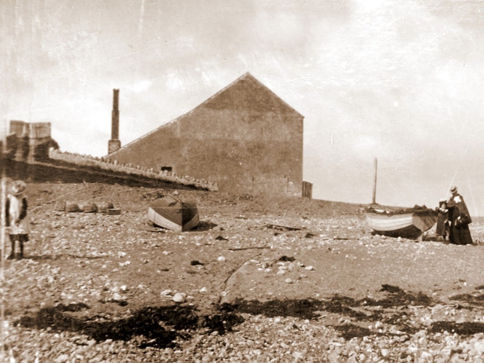
This is the other half of the previous photograph showing the side of the Cement Works with no windows in it and a large chimney at the back of it.
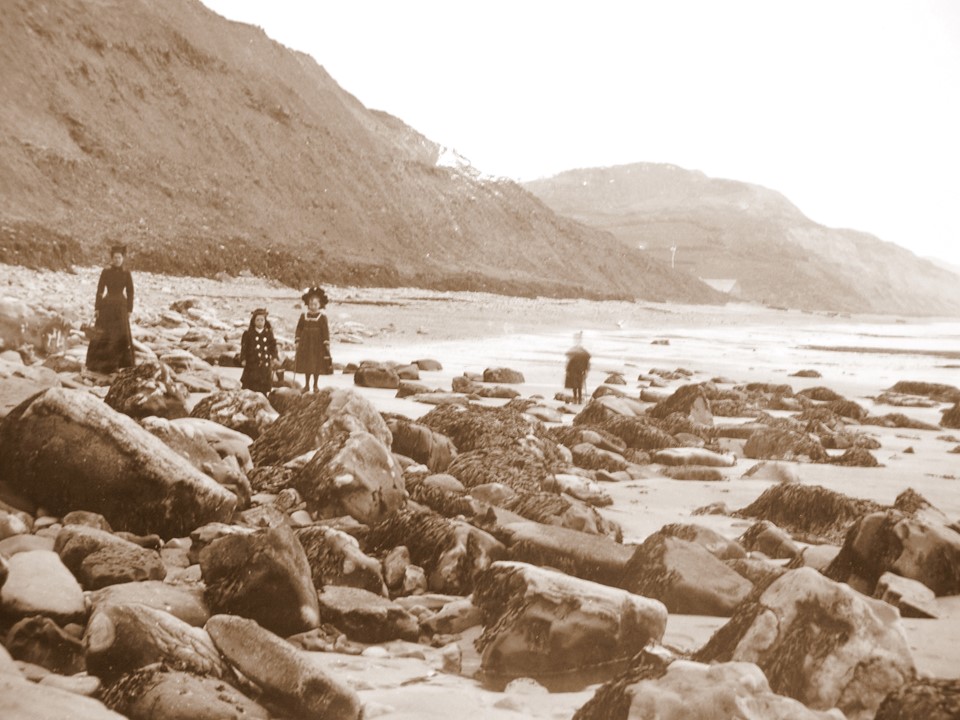
Some fully dressed Victorian holiday makers enjoying strolling on the rocks. In the distance the silhouette of the Cement works can be seen.
In 1897 Queen Victoria`s Jubilee was commemorated by the construction of a Shelter. Sadly there are no traces today of this structure, but photographs of the time show it in all its glory. It would have stood at the top of what is today the Car Park by the present bridge that crosses the river there. This area has changed dramatically as at the time of its construction the River Char formed an Ox bow with an earlier wooden footbridge crossing the bend in the river near the Cement Works (Heritage Centre). This would have taken visitors over to a piece of land known as “the Spit” to the East Cliff. It had been the site for two 24 pounder and one 64 pounder guns that were fired periodically by the local Volunteers to a target consisting of a barrel with a flag on it out to sea. They stored their ammunition in a brick building nearby known as “the Battery”. When the Volunteers were disbanded in 1895 their Band was retained and the building became redundant. Rather than leaving it empty it was decided to convert it into a shelter to mark the Jubilee.
Photographs show the original Battery covered with a pointed roof, which was supported by number of timber pillars protecting the benches below
A close up of The Jubille Shlter which was created by constructing covered seating around the former Battery where ammunition was kept by the local Reserves whose cannons were on the beach where the Car Park is today.
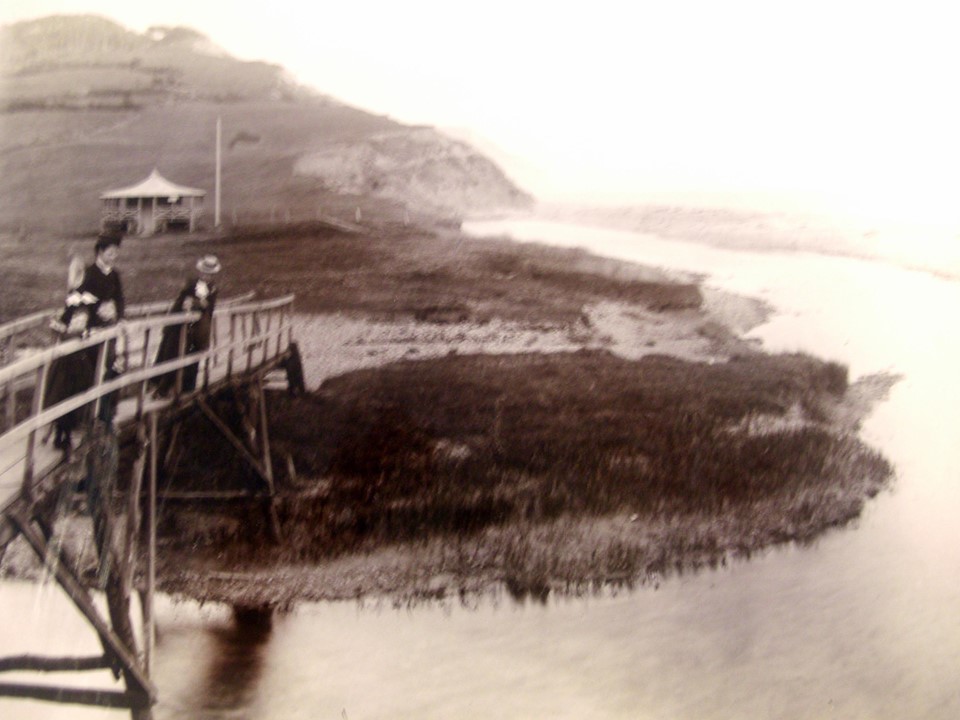
A group of well dressed Ladies lean over the rickety old bridge which went over the river by the present day Heritage Centre
A Close up of the Jubilee Shelter and the bridge that crossed the river which at that time went alongside the former Cement Works.