The
Hundred of Bradford


The
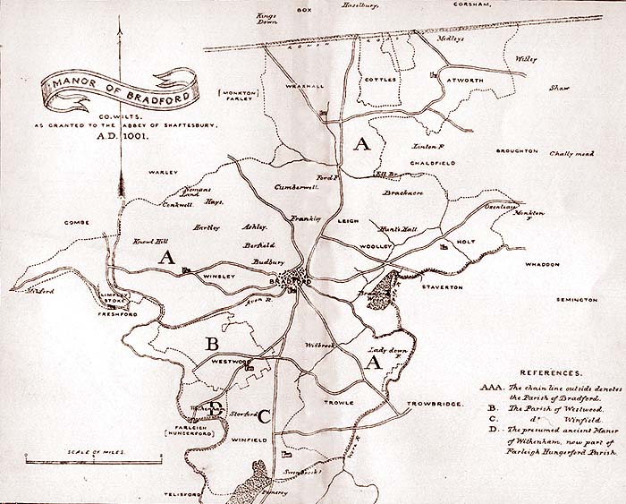
Manor of Bradford as granted by King Ethelred to the Abbey of Shaftesbury in AD
1001, based on Canon Jones Map. B is the parish of Westwood, C the Parish of Wingfield,
D the Ancient manor of Withenham


The
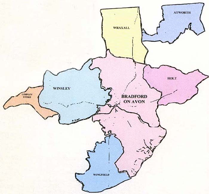
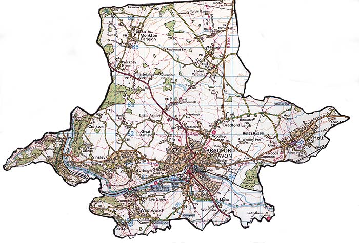
Manor of Bradford today , now comprising the Parishes of Bradford on Avon, Monkton
Farleigh, South wraxall, Limpley stoke, Winsley, Holt and Westwood.
In A.D. 1001 Ethelved materially increased the possessions of the Abbess of Shaftesbury by bestowing upon her the Monastery and Vill (i.e. the Manor) of Bradford; such a gift implying that at this time the manor was in the hands of the king. It was given, to use Leland's words, " for a recompence of the murdering of S. Edward his brother ; " of which deed, though it was carried out by the orders of Elfnda, Ethelred was supposed not to be wholly guiltless. The Charter, by which he granted to the Abbess this addition to her revenues, is still in existence. It ia to be found among the Harleian MSS. in the British Museum.The charter ia an interesting document, as it gives us an account not only of the specific object for which Ethelred bestowed Bradford upon the Abbess, but also distinctly marks out (insomuch that we can for the most part trace them now) the boundaries of the Vill and Manor, or, as we should say, the Parish. On the former point Ethelred states that "he gave to the Church of St. Edward at Shaftesbury the monastery and vill of Bradeford, to be always subject to it, that therein might be found a safe refuge (his exact words are " impenetra-Hle confucfium") for the nuns against the insults of the Danes, and a hiding-place also for the relics of the blessed martyr St. Edward and the rest of the saints," He expresses moreover his wish " that on the restoration of peace, if such were vouchsafed to his kingdom, the nuns should return to their ancient place, but, that some of the family should still remain at Bradford if it be thought fit by their superior." It was indeed at an eventful crisis that he granted this charter. The miseries of his troublous reign seem to have well nigh reached their culminating point. Again and again had meetings of the Witena-gemote been held, their deliberations issuing only in the fatal step of buying off with large sums of money the opposition of their dreaded foe. In this very year of which we are speaking, the Northmen devastated Waltham, Taunton,*and Clifton, and were only induced to desist from further ravages by the immense bribe of £24,000.
What was precisely meant by Bradford being called "impenetrable confugium" is not very clear. Probably it was by no means easy of access to a large armed force, and, in the event of their approach, the surrounding woods would furnish a secure hiding-place for the members of the sisterhood. However, hither the Danes came, and within a few years at most from this time, the monastery is said to have been levelled with the ground. That most treacherous act of Ethelred, by which, on St. Brice's day, A.D. 1002, he ordered an indiscriminate massacre of the Danes, who, trusting to his promises, deemed themselves living at peace with him, exasperated them to madness, and they spared nothing. It is not improbable that either in the year 1003, when Sweyn laid waste Wiltshire, or in 1013, when, at Bath, he received the submission of the Ealdorman Ethelmar and the rest of the Western Thanes, our monastery fell. After 1016, the date of the accession of Canute the Dane, to the throne of England, it was not likely that the Northmen would destroy what then they might fairly reckon as their own.
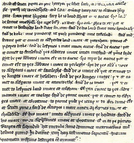
On the second point,-viz., the limits of the Manor of Bradford,-the charter is very explicit. This portion of the deed is not written, as the remaining parts of it are, in Latin, but in Anglo-Saxon, and that of a very late period and consequently of an impure character. We append a copy of it, together with a translation, side by side. Kemble's text, which has been adopted, is the nearest probably to the original, but even this, being a corrupt transcript of the Semi-Saxon period, presents so many difficulties, in addition to those usual in Anglo-Saxon boundaries, that the translation must be received, in several instances, only as a conjectural approximation to the true reading.
In the accompanying map, (Plate i.) all included within the dotted line represents the original manor, as described in the following extract from the charter.
First, from seven pear trees on that military way that shoots southward without Acceslegle(1) farm out of Wrindes holt(2) and so along the military way to AElfwin's stile (leap-gate) ; from the stile forth by his balk to the Avon; so forth by the stream to the Biss ;(3) then up the Biss on the right; so along on the right till you come to Brisnode's balk(4) (the shoe-maker's ?); forth by his balk to Swinbrook ,(1) forth by the brook to Pomeroy; out through Pomeroy to Tellesford; forth with the stream till you come to AElfwerd's landmark at Wutenham;(2) thence from wigewen(3) brook forth by Leofwin's boundary to the Avon ; forth by the Avon till you come to Freshford the boundary of the Abbot in Mitford ; from the ford you go by the Abbot's boundary ; then back to the Avon; so on there by the Avon till you come to the Abbot's boundary at Warleigh; so by the Abbot's boundary to AElf gar's boundary at Farleigh; forth by his boundary till you come to the King's boundary at Haselbury ;(l) forth by the King's boundary till you come to AElfgar's boundary at Atworth; forth by by his boundary till you come to Leofwin's landmark at Corsham; from that boundary to the alderman's boundary at Witley; forth by that boundary till you come to AElfwy's boundary at Broughton to the wood(2) that runs into Broughton; again at seven (1) pear trees; forth by AElfnode`s boundary to Aethelwin`s boundary at Chalfield; from this boundary to the boundary of Aelfwine theTreasurer (?); forth by his boundary to AElphwin's boundary at Broughton; back to the pear trees.
It will be seen, that as far as we can trace with accuracy the description given in the charter of the extent of the ' vill of Bradford,' it includes, not only the present boundaries of the parish, but the parishes of Winfield, Westwood, and a part of what is now in the parish of Farleigh Hungerford. Of Westwood we may say, in passing, that, though in a different hundred from Bradford, and in many respects quite independent of it, it has from time immemorial been held jointly with Bradford. As early as 1299, in the reign of Edward I., it is spoken of as the 'Chapel of Westwode in the parish of Bradford,' one "John de Waspre" being named as "Pa-tronus"; and "Eobert de Hauvyle" as, "Clericus."(2). It must have been severed from the manor of Bradford no long time after the date of this gift to Shaftesbury, for we find it bestowed on Winchester Bishopric by Queen Emma, mother of Edward the Confessor.
1.Acces-legle farm. The original meaning of this word was Oak's-leigh. In our word a-corn (A.S. de-corn i.e. the seed of the oak,) we have preserved the original spelling. By degrees Oak's-leigh was corrupted into Ox-ley, and now into Oxenleaze, the present name of the farm, It is situated in the Holt Tithing at the eastern extremity of the parish of Bradford, just where the road branches off to Melksham. These seven pear trees,-(by the way, one is tempted to read wiSien, that is, withies, instead of pirien, pear trees, the words being easily mistaken for one another when written in Anglo-Saxon characters)-were planted as landmarks, to denote the spot where the parishes of jBroughton, Melksham, and Bradford met. Kemble notices the frequency with which the withy is mentioned in describing boundaries in A.S. charters. (Cod. Dip. iii. Introd. p. xli.)
2.Wrindes holt i.e. wood. A great part of this Tithing, as its name denotes, was no doubt originally wood-land. May Wrindes holt have been corrupted first of all into ' Bunt's Holt' and, in course of centuries, into ' Bunt's Hall' ? The situation of the last-mentioned place sufficiently corresponds with the description in the charter to give some colour to the supposition. \Rinde, a thicket, small wood. Halliwell.~\
3.The Biss. This river, on which Trowbridge is situated, enters the Avon by Lady Down Farm. The meadow at that point is called Biss-Mouth Meadow.
4.Brisnode's balk. By this word, which has not yet passed out of use in Wiltshire, we translate the Anglo-Saxon ' land-schare,' which denotes the ridges or other boundaries, by which one estate was divided frojji another. This land-share must be on the eastern side of Trowle common., commeno-Jng possibly from the point where the road from Bradford ttf Trowbridge waves the former parish. In Andrews and Dury's map (1773) the stream which flows into the Biss at this point is called ' The Were,' and is repre. sented as rising near Southwick. This may perhaps explain Camden's statement, that Trowbridge is situated on the Were. (Brittaunia wbson's edition), i. 199.) In the accompanying map, the Were is J-presented as forming the south eastern boundary of Bradford parish. *ais is not the case with respeot to the present boundaries, several portions on the eastern side of the stream being in Trowbridge. Originally all this part was common land. As from time to time the common has been enclosed, allotments of various portions of it have been made to the different parishes, whose inhabitants had the right of pasturage upon it. In olden times, possibly the stream formed the boundary of ' the Manor.'
1 Swinbrook. This name has now been lost. I can have little doubt however, that it was the original name of the brook which forms, for the most part, the southern boundary of Winfield (now spelt Wingfield or Winkfield) parish. This brook rises in Pomeroy, and flows in a Southeastern [? eastern] direction, till it empties itself into the Were. Winfield, in Domesday Book is written Wine-fel. Does the name of the brook give us the key to the original name of the parish ? In the immediate vicinity are several fields that bear the name of Hook-woods, which looks very much like a corruption of Hog-woods, a name still preserved at Hinton-Charter-house, about three miles from the spot in question.
2 Wutenham. This name is now lost. We meet with the name ' Withenham,' however, in the Wilts Institutions, several presentations to the Church of that parish being therein recorded. The Church stood> most probably, half-way between Westwood Church and Farleigh Bridge, at a point where four roads meet. Tradition preserves the fact of there having been a church there, and a separate hamlet and parish, called Rowley alias Withenham. In 1428, the church being dilapidated, Walter, Lord Hungerford obtained permission to unite " Withenham alias Rowley " Church and parish with Farleigh. This is the reason why, to this day, Farleigh Hungerford parish stands partly in Somerset and partly in Wilts. There were two distinct manors. Withenham, held by the Hungerfords under the Lord Zouche; Rowley, held by them under the Abbess of Shaftesbury. The name and manor of Bowley still survives. Captain Gaisford's property, called Wiltshire Park, is part of it, and a lane there is still called Bowley lane. Withenham was probably on the Winfield side of the lane, as in Domesday Book it is mentioned next to Wine-fel and was held by the same person. It most likely spread over that portion of ground which lies between the cross in the lanes, already alluded to, and Stowford.
3 Wige wen brook. There is no name at all like this, (the literal meaning of which is 'war-chariot,') given to any brook in the direction indicated, at the present time. Andrews and Dury designate a portion of the stream ' Iford Brook.' The present boundary line of the parish of Westwood leaves the river at Iford (which is partly in Westwood andpartly in Freshford parish) and bearing first of all to the west and then to the north-east, reaches the Avon very near to the point where the river Frome empties itself into it. In a charter of Ethelred (A.D. 987,) printed in Eemble's Cod. Dipl. iii. 229, we find Iford spelt Ig-ford, that is, ' island ford,' from which we may infer that there was, no doubt, a brook or rivulet formerly, though we have lost the trace of it. [This wigewen brook must surely have been the Frome, which is not here mentioned by that name.]
1 Haselbury. This is now the name of a Farm-house, with spacious premises, the remains of its former importance, in the parish of Box. John Leland was entertained there by John Bonham in 1541. Formerly there was a Church at Haselbury, though all traces of it have now been lost. The estate belongs to the Norlthey family. [See vol. i. p. 144, of this Magazine.] The name of King's Down, which is in the immediate vicinity of Haselbury, preserves the memorial of the fact recited in the charter that the Crown formerly had possessions there.
2The Wood that runs into Broughton. Though most traces of this wood nave disappeared, yet there is no doubt that the north-western part of this parish was, in early times, thickly covered with wood. Several portions of ground in that part of Broughton still bear names which indicate this fact, snch as, Broughton Woods, Light Woods, &c.
1 Seven pear-trees. These can hardly be the same trees, already alluded to. These trees were no doubt planted at the point where the parishes of Broughton, Chalfield, and Bradford (Atworth) met.
2 Wilts Institutions, sub anno 1299.